Maps of Balkan Pen.

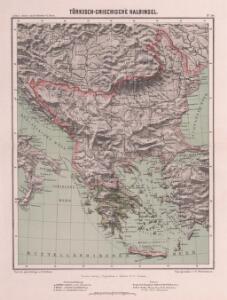
Türkisch-Griechische Halbinsel
Balkanhalbinsel
Europäische Türkei & Griechenland
Osmanisches Reich / Europäischer Teil, Griechenland
[Neuer Atlas der ganzen Erde nach den neuesten Bestimmungen ... : XXIII.] Griechenland, die Jonischen Inseln und das Osmanische Reich in Europa
Entworfen und gezeichnet von Dr. F.W. Streit H. Leutemann sc. Leipzig : J.C. Hinrichs'sche Buchhandlung
CHARTE von der Europäischen TÜRKEI
1 : 4200000 Turecko západní
Charte von der Europäischen Türkei
1 : 4200000 Balkánský poloostrov Streit, Friedrich Wilhelm
Charte von der Europäischen Türkei
1 : 4200000 Balkánský poloostrov
Charte von der Europäischen Türkei
1 : 4200000 Balkánský poloostrov
Die europäische Türkey und Griechenland
1 : 4600000 Balkánský poloostrov geogr. lith. Anstalt von L. Holle
Balkanhalbinsel.
1 : 3000000 Andree, Richard
Turchia Europea con i Principati di Servia, Valachia e Moldavia.
1 : 3540000 Picquet, C.
Turquie d'Europe, Grece.
1 : 3000000 Lapie, M. (Pierre), 1779-1850
Die Europaeische Türkey und das Königreich Griechenland
Osmanisches Reich / Europäischer Teil, Griechenland
Türkei und Griechenland
Neuer Handatlas über alle Theile der Erde Kiepert, Heinrich Verlag von Dietrich Reimer
Turquie d'Europe.
1 : 3500000 Picquet, C.
Das Osmanische Europa oder die Europaeische Türkey nebst dem Koenigr. Griechenland und den Jonischen Inseln
1 : 2850000 entworfen und gezeichnet von C.F. Weiland Weimar : im Verlage des Geograph: Instituts
Charte von der europaeischen Tuerkey von Griechenland und den Ionischen Inseln
Balkanhalbinsel, Osmanisches Reich
Turkey in Europe.
1 : 6000000 Higgins, W.M.
Türkei und Griechenland
1 : 5400000 Osmanisches Reich, Griechenland
Turquie d'Europe, Grece.
1 : 3500000 Andriveau-Goujon, J.
Ethnographische Übersicht des europäischen Orients
Bospor (Turecko : průliv) Kiepert, Heinrich D. Reimer
[Karte der Balkan-Halbinsel]
Balkánský poloostrov
Osman. Europa.
1 : 3000000 Weiland, C. F. (Carl Ferdinand), d. 1847
Turquie d'Europe, Grece &c.
1 : 3900000 Garnier, F. A., 1803-1863
Das osmanische Europa oder die europaeische Türkey
1 : 3000000 Balkánský poloostrov Weiland, Karl Ferdinand Boué Geographisches Institut
Das osmanische Europa oder die europaeische Türkey
1 : 3000000 Bospor (Turecko : průliv) Weiland, Karl Ferdinand Boué Geographisches Institut
Das osmanische Europa oder die europaeische Türkey
1 : 3000000 Bospor (Turecko : průliv) Weiland, Karl Ferdinand im Verlage des Geograph. Instituts
Das osmanische Europa oder die europaeische Türkey
1 : 3000000 Dardanely (Turecko : průliv) Weiland, Karl Ferdinand im Verlage des Geograph. Instituts
Das osmanische Europa oder die europaeische Türkey
1 : 3000000 Dardanely (Turecko : průliv) Weiland, Karl Ferdinand Geograph. Institut
Das osmanische Europa oder die europaeische Türkey
1 : 3000000 Dardanely (Turecko : průliv) Weiland, Karl Ferdinand Ciliax, L. Geograph. Institut