Maps of Balkan Pen.

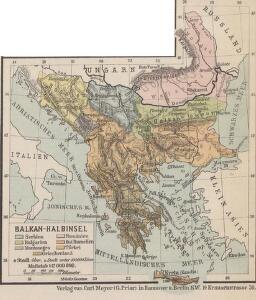
Balkan-Halbinsel
1 : 12000000 Balkanhalbinsel
Charte vom Türkischen Reiche in Europa
1 : 3400000 Balkánský poloostrov Reinecke, Johann Christoph Matthias im Verlage des Industrie Comptoirs
Charte von der europaeischen Tuerkey von Griechenland und den Ionischen Inseln
Balkanhalbinsel, Osmanisches Reich
Südost -Europa
1 : 2000000 Evropa jihovýchodní Peucker, Karl Artaria
Türkei und Griechenland
1 : 5400000 Osmanisches Reich, Griechenland
Karte der Balkan Halbinsel
1 : 3000000 Balkánský poloostrov Schlachter, J. J. Schlachter
Die Europaeische Türkey und das Königreich Griechenland
Osmanisches Reich / Europäischer Teil, Griechenland
[Neuer Atlas der ganzen Erde nach den neuesten Bestimmungen ... : XXIII.] Griechenland, die Jonischen Inseln und das Osmanische Reich in Europa
Entworfen und gezeichnet von Dr. F.W. Streit H. Leutemann sc. Leipzig : J.C. Hinrichs'sche Buchhandlung
Charte vom Türkischen Reiche in Europa
1 : 3400000 Balkánský poloostrov Reinecke, Johann Christoph Matthias im Verlage des Geogr. Instituts
Das osmanische Europa oder die europaeische Türkey
1 : 3000000 Evropa jihovýchodní Weiland, Karl Ferdinand Jungmann, Carl Geograph. Institut
Turquie d'Europe, Grece.
1 : 3500000 Andriveau-Goujon, J.
75-76. Penisola balcanica.
1 : 3000000 Touring club italiano
Karte des osmanischen Europa oder der europäischen Türkei
Originaltitel: Das osmanische Europa oder die europäische Türkei nebst dem Königreich Griechenland und den ionischen Inseln. Mit Erklärung der Zeichen, Legende der Farben sowie zwei Nebenkarten der Dardanellen und der Umgebung von Konstantinopel. Entwurf und Zeichnung: Weiland, C. F., in Weimar Verlag des geographischen Instituts
La Turquie d'Europe, La Hongrie, La Transilvanie, La Croatie, La Morlaquie, La Sclavonie et La Dalmatie avec La Rép.que des Sept Iles
1 : 3700000 par J. B. Poirson gravé par Tardieu l'ainé [Paris] : [Mentelle etc.]
Freytag & Berndt's Handkarte von Sudost-Europa
1 : 2000000 Kartographisches Anstalt Freytag-Berndt Wien : Freytag & Berndt
Türkei und Griechenland
Neuer Handatlas über alle Theile der Erde Kiepert, Heinrich Verlag von Dietrich Reimer
Das osmanische Europa oder die europaeische Türkey
1 : 3000000 Balkánský poloostrov Weiland, Karl Ferdinand Boué Geographisches Institut
Das osmanische Europa oder die europaeische Türkey
1 : 3000000 Bospor (Turecko : průliv) Weiland, Karl Ferdinand Boué Geographisches Institut
Das osmanische Europa oder die europaeische Türkey
1 : 3000000 Bospor (Turecko : průliv) Weiland, Karl Ferdinand im Verlage des Geograph. Instituts
Das osmanische Europa oder die europaeische Türkey
1 : 3000000 Dardanely (Turecko : průliv) Weiland, Karl Ferdinand im Verlage des Geograph. Instituts
Das osmanische Europa oder die europaeische Türkey
1 : 3000000 Dardanely (Turecko : průliv) Weiland, Karl Ferdinand Geograph. Institut
Das osmanische Europa oder die europaeische Türkey
1 : 3000000 Dardanely (Turecko : průliv) Weiland, Karl Ferdinand Ciliax, L. Geograph. Institut
Carte de la Turkie d'Europe
1 : 3600000 Evropa jihovýchodní Lapie, Pierre Arnoul Firmin Didot
Ethnographische Übersicht des europäischen Orients
Bospor (Turecko : průliv) Kiepert, Heinrich D. Reimer
[Karte der Balkan-Halbinsel]
Balkánský poloostrov
Die Europäische Türkey, Griechenland, Dalmatien und die Republik Montenegro
Schul-Atlas in 36 Karten Völter, Daniel Verlag der J.M. Dannheimer'schen Buchhandlung
Europäische Türkei & Griechenland
Osmanisches Reich / Europäischer Teil, Griechenland
CHARTE von der Europäischen TÜRKEI
1 : 4200000 Turecko západní
Charte von der Europäischen Türkei
1 : 4200000 Balkánský poloostrov Streit, Friedrich Wilhelm
Charte von der Europäischen Türkei
1 : 4200000 Balkánský poloostrov