Maps of Turkey

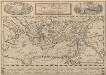
Das Osmanische Reich nebst seinen Schutzstaaten nach seiner grössten Ausdehnung 1682
Osmanisches Reich
Das Osmanische Reich nebst seinen Schutzstaaten nach seiner grössten Ausdehnung 1682
Osmanisches Reich
Das Oströmische Reich zur Zeit Karls des Gr.
Byzantinisches Reich
Carte générale des provinces européennes et asiatiques de l'Empire Ottoman, uit: Carte générale des provinces européennes et asiatiques de l'Empire Ottoman (sans l'Arabie) / dressée par Henri Kiepert ; le trait et la lettre gravés chez L. Kraatz ; le figure du terrain gravé par J. Sulzer
1 : 3000000 Annotatie: Op omslag ook: Deuxième édition entièrement corrigée et augmentée d'un index alphabétique (quatrième édition de la 'Carte générale de l'Empire Ottoman en Europe et en Asie'); Met: Index alfabétique. - 40 p; Annotatie geografische gegevens: Legenda Johann Samuel Heinrich Kiepert 1818-1899; Leopold Kraatz; J. Sulzer Berlin : Dietrich Reimer (Hoefer u. Vohsen) / ([S.l. : L. Kraatz])
[Des Mittelländischen Meeres öestliches Blatt. Zur Uebersicht des Türkischen Reichs und als Pecial-Karte der Asiatischen u. Afrikanischen Türkey]
Stieler's Hand-Atlas Stieler, Adolf bei Justus Perthes
Das Oströmische Reich zur Zeit Karls des Gr.
Byzantinisches Reich
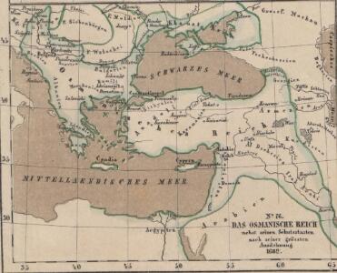
Das osmannische Reich, XVIIten Jahrhundert.
1 : 9200000 Spruner von Merz, Karl
Carte générale de l'Empire Ottoman en Europe et en Asie
1 : 3000000 osmanská říše Kiepert, Heinrich D. Reimer
Tableau l'historie de l'Empire des Califes et de l'Empire de Turquie.
1 : 20000000 Duval, Henri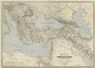
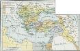
General-Karte des Türkischen Reiches in Europa und Asien nebst Ungarn, Südrussland, den kaukasischen Ländern und West-Persien
1 : 3000000 entworfen und bearb. von Heinrich Kiepert Stich und Druck der lithographischen Anstalt von L. Kraatz Berlin : Reimer
Übersichts - Karte des Türkischen Reichs in Europa und Asien
Osmanisches Reich bis 1683
1 : 18000000 Osmanisches Reich Expansion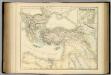
Turkish Empire.
1 : 5702400 Fullarton, A. & Co.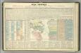
Tableau historique de l'Empire d'Oriens.
1 : 18500000 Duval, Henri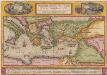
Peregrinationis Divi Pauli Typus Corographicus [...] [Karte], in: Theatrum orbis terrarum, S. 442.
1 Karte aus Atlas Ortelius, Abraham
Orbis Romani, orientalis.
1 : 11500000 Anville, Jean Baptiste Bourguignon d, 1697-1782; M'Dermut, Robert
Osmanisches Reich und seine Schutzstaaten im XVIIten Jahrhundert
1 : 9000000 Osmanisches Reich Protektorat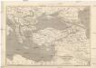
Map of the Ottoman Empire, Kingdom of Greece, and the russian provinces on the Black Sea
1 : 5900000 balkánské země Dower, John
Die Türkey
Evropa jihovýchodní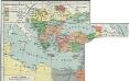
I. Osmanisches Reich bis 1683
1 : 28000000 Osmanisches Reich Expansion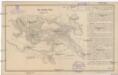
Das türkische Reich
Afrika severní
Das Osmanische Reich nach seiner grössten Ausdehnung im XVIIten Jahrhundert
1 : 12000000 Osmanisches Reich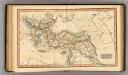
Ottoman Empire.
1 : 14100000 Fenner, Rest.
Türkey
Allgemeiner Atlas [Walch, Johannes] im Verlag bei Johannes Walch
Orbis Romani Pars Orientalis.
1 : 10137600 Lucas, Fielding Jr.
Orbis Romani, pars orientalis.
1 : 4300000 Anville, Jean Baptiste Bourguignon d, 1697-1782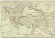
Europaeische und asiatische Türkey
1 : 4250000 Blízký východ Mollo, Tranquillo T. Mollo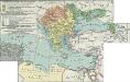
II. Rückgang des Osmanischen Reichs (Orientalische Frage) seit 1683
1 : 28000000 Osmanisches Reich
Turkish Empire, Greece.
1 : 7200000 Society for the Diffusion of Useful Knowledge (Great Britain)