Maps of Alps
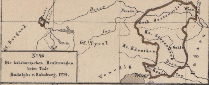
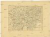
Die habsburgischen Besitzungen beim Tode Rudolphs v. Habsburg 1291
Österreich Rudolf I., Heiliges Römisches Reich, König
Das allmälige Wachsthum des österreichischen Staates. No. 46 Die habsburgschen Besitzungen beim Tode Rudolphs v. Habsburg 1291
Österreich Rudolf I., Heiliges Römisches Reich, König
Sud-Ostliches Deutschland nebst einem Theile des nordlichen, Italien.
1 : 1850000 Berghaus, Hermann
Die Alpenlaender
1 : 1900000 Alpy-oblast Köke, Friedrich Eduard Hölzel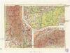
Rakousko
1 : 2000000 Maďarsko Škorpil, František Bohumil Státní nakladatelství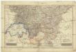
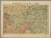
Südwestliche deutsche Bundesstaaten
1 : 2500000 Německo jižní Huber, D.
Der Oesterreichische Kreis
1 : 1380000 Evropa střední Güssefeld, Franz L. Liesganig, Joseph bey den Homannischen Erben
Der Oesterreichische Kreis
1 : 1340000 Rakousko (1526-1804) Güssefeld, Franz L. Liesganig, Joseph bey Homannischen Erben
Der Oesterreichische Kreis
1 : 1340000 Rakousko Güssefeld, Franz L. Liesganig, Joseph bey den Homannischen Erben
Autriche, Italie du Nord / P. Bineteau del.
1 : 900000 Bineteau, P. Paris : Taride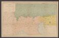
Sprachkarte der Alpen
1 : 2000000 Wäber, Adolf ; Leuzinger, Rudolf [Verlag der Expedition des Jahrbuches des S.A.C.]
Sbírka map a diagramů použitých na mírových konferencích v Paříži v letech 1919 - 1920
Charte von Oestreich Steyermark, Illyrien und Tyrol
1 : 1600000 Ilýrie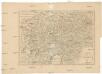
Charte von Oestreich Steyermark Illyrien und Tyrol
1 : 1550000 Ilýrie
Maiestas Austriaca sive circ. archiducat. Austriae
1 : 3400000 Evropa střední Seutter, Matthäus Lotter, Tobias Conrad Tobias Conrad Lotter
Autriche
1 : 1000000 Rakousko Čs. voj. zeměp. ústav
Leopoldi Magni filio Iosepho I. Avgvsto Romanorvm et Hvng. regi ad capessendum Rhenanae militiae imperium in castra proficiscenti hanc Germaniae Avstriacae generalem tabvlam
1 : 1430000 Evropa střední Homann, Johann Baptist Io. Bapt. Homann
Nejnovější cestovní mapa zemí aplských

Géographie. croquis n4, Entre Pô et Danube
1 : 1000000 Molard, Jules, Commandant [Paris] : Service Géographique de l'Armée
Übersichtskarte der evangelischen Kirche Augsb. und Helv. Confession
1 : 864000 Chorvatsko Strehl, Anton k. k. evangel. Oberkirchenrathe
Hypsometrische Uebersichtskarte der Alpen
1 : 1744000 Alpy (pohoří) Steinhauser, Anton Papen, August Artaria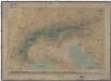
Hypsometrische Uebersichtskarte der Alpen
1 : 1744000 Alpy (pohoří) Steinhauser, Anton Papen, August Artaria
Austria.
1 : 2700000 Bowen, Frances
Automobil-Karte der Republik Österreich: Österreichischen Touring-Buch

Generalcharte von Oesterreich, Tyrol, Steyermark und Illyrien
1 : 1600000 Horní Rakousko (Rakousko) Schönberg, Johann bey Johann Schönberg
Karte der Republik Österreich
1 : 1500000 Rakousko Rothaug, Johann Georg Kartogr. Anstalt G. Freytag & Berndt
(Order form for) Generalkarte von Europe.
Scheda, Josef
[Süd-Östliches Deutschland nebst einem Theile des nördlichen Italien]
Hand-Atlas über alle Theile der Erde und über das Weltgebäude Stieler, Adolf Justus Perthes