Maps of Poland

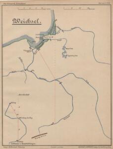
Weichsel
Weichsel (Fluss), Flusslauf
Deutsch-österreich-russische Grenze
Polen Grenze
Superficie de petites exploitations privées (au-dessous de 50 ha) en proportions pour cent de la superficie générale
1 : 5000000 Polsko w Biurze kartograficznem
Carte géologique de la République Polonaise
1 : 2500000 Kuźniar, Czesław; (Pologne) Service Géologique Lwów : Service Géologique de Pologne
Feuille 25 (D IV), uit: Carte géologique internationale de l'Europe : la carte, votée au congrès géologique international de Bologne en 1881, est exécutée conformément aux décisions d'une commission internationale, avec le concours des gouvernements, sous le dir. de M.M. Beyrich et Hauchecorne
Annotatie: Blad 48 gamme des couleurs; blad 49: bladwijzer en titelblad Heinrich Ernst Beyrich 1815-1896; Wi. Hauchecorne Berlin : Reimer / (Berlin: Institut lithographique)
Republika polská
1 : 1000000 Bělorusko
Republika Polská

Übersichtskarte des Östlichen Kriegsschauplatzes
1 : 4500000 Osteuropa Polen Litauen Weißrussland Galizien und Lodomerien Weltkrieg <1914-1918> Verl. Gerhard Stalling, Oldenburg
Übersichtsblatt zur Karte des westlichen Russlands
1 : 100000 Russland Weißrussland Grenzgebiet Kartogr. Abteilung der Kgl. Preuß. Landesaufnahme
Poland.
1 : 3576320 Cummins Map Co.
Nr. 15. Der Krieg in Westrußland im Herbst 1915
Polen Weltkrieg <1914-1918>, Ostfront
Nr. 18b. Hindenburgs Züge
Polen Weltkrieg <1914-1918>, Ostfront
Poland, Prussia.
1 : 4400000 Darton, William
Polen
1 : 1280000 Bělorusko Rizzi Zannoni, Giovanni Antonio Artaria
Polen
1 : 1280000 Bělorusko Rizzi Zannoni, Giovanni Antonio Artaria
Poland, 1:2,000,000
1 : 2000000
Poland.
1 : 2400000 Playfair, Principal
Uebersichts Karte von Ost und West Preussen und Polen

Východní fronta 1914

Das Königreich Polen nebst den Königl. Preussischen Provinzen Preussen und Posen nebst dem Gebiete der freien Stadt Krakau
Preußen, Kongresspolen
Plastická mapa zemí Sudetských a Karpatských
Evropa střední E. Šolc
Östlicher Kriegsschauplatz I
1 : 5000000 Ostmitteleuropa Weltkrieg <1914-1918>, Ostfront
Germany, eastern border regions : administrative divisions
1 : 2570000 Inset: Major administrative divisions. "July 1, 1944, information is shown within the 1937 Germany boundary only." "No. 6275." United States. Office of Strategic Services. Research and Analysis Branch. [Washington, D.C.] : R & A, OSS
Charte von Polen
1 : 2320000 Halič (Polsko a Ukrajina) bey Artaria
Charte von Polen
1 : 2320000 Halič (Polsko a Ukrajina) bey Artaria
Charte von Polen
1 : 2320000 Halič (Polsko a Ukrajina) Artaria
Die Lage Ende März
Polen Weltkrieg <1914-1918>, Ostfront
Geschichtl. Entwicklung des Königr. Preussen bis zum Frieden von Tilsit (1807)
Preußen, Polen, Tilsit / Friede
Polen und Preussen 1240 - 1386
1 : 6000000 Polen, Preußen (Ordensstaat)