Maps of Scandinavia

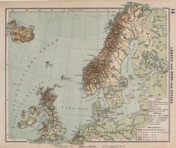
Länder der Nord- und Ostsee
1 : 10000000 Nordeuropa
Dänemark, Island u Färöer, Schweden und Norwegen
Hand-Atlas über alle Theile der Erde nach dem neuesten Zustande und über das Weltgebäude Stieler, Adolf bei Justus Perthes
Dänemark, Jsland u. Färöer, Schweden und Norwegen
Stieler's Hand-Atlas Stieler, Adolf bei Justus Perthes
Schonlandia XIII Nova Tabula [Karte], in: Geographia universalis vetus et nova complectens Claudii Ptolemaei Alexandrini enarrationis libros VIII, S. 335.
1 Karte aus Atlas Münster, Sebastian [und Ptolemaeus, Claudius]
Schonlandia XIII Nova Tabula [Karte], in: Claud. Ptolemaeus. Geographia lat. cum mappis [...], S. 389.
1 Karte aus Atlas Münster, Sebastian [und Ptolemaeus, Claudius]
Northern Europe. Pergamon World Atlas.
1 : 5000000 Polish Army Topography Service
Kaart van Noorwegen, Denemarken, ijsland, Zweden, Finland, Engeland en de Noordzee / W. Seghers
1 : 4000000 Seghers, W. Antwerpen : Patria [etc.]
Tabula Moderna Prussie Livonie Norbegie Et Gottie. [Karte], in: [Clavdii Ptholomei Cosmographi ...], S. 263.
1 Karte aus Atlas Nicolaus Germanus [und Ptolemaeus, Claudius]
North Sea, Baltic cables, wireless stations.
1 : 12500000 Philip, George
The countries of northern Europe

[Ethnographische Karte von Europa]
Zweiter Band, enthaltend in vier Abtheilungen die Vertheilung der Organismen: 5. Pflanzen-Geographie, 6. Thier-Geographie, 7. Anthropographie, 8. Ethnographie Humboldt, Alexander von Verlag von Justus Perthes
Schweden, Norwegen, Daenemark.
1 : 4000000 Ziegler, J. M.
Karte von Europa, 1
4 Blätter : 53 x 70 cm Verlag der Königlich-Preussischen Academie-Kunst- und Buchhandlung
Schweden und Norwegen oder Scandinavische Halbinsel Königr. Daenemark
Geographischer Atlas über alle Theile der Erde Ziegler, Jakob Melchior Verlag von Joh. Wurster um Comp.
Evropa, 1
1 Blatt : mehrfarbig ; 49 x 57 cm Homännische Erben
Schweden Daenemarck u. Norwegen
Dánsko Mollo, Tranquillo Tranquillo Mollo
Spannungen in Nordeuropa
1 : 5000000 Evropa severní List & von Bressensdorf
Evropa XIX. století: od vídeňského kongresu r. 1815, do rozhodnutí na frontách světové války r. 1918
Kašpar, Jan
Der Westhandel Nordosteuropas in der Frühen Neuzeit
Europa (Nordost) Handel
Hollande et Belgique, Suede et Danemark.
Andriveau-Goujon, J.
Neueste Karte von Schweden und Norwegen
Grosser Hand-Atlas über alle Theile der Erde in 170 Karten Meyer, J. Verlag des Bibliographischen Instituts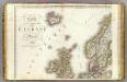
Europe 1.
1 : 3850000 Brue, Adrien Hubert, 1786-1832
Charte von Schweden und Norwegen
1 : 3700000

Nord- und Ostseeherrschaft I: Reich Knuts des Großen
1 : 12000000 Nordeuropa Knud II., Danmark, Konge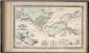
The Baltic Sea.
Mitchell, Samuel Augustus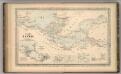
The Baltic Sea.
Mitchell, Samuel Augustus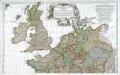
Prémière partie de la carte d'Europe contenant la France, l'Alemagne, l'Italie, l'Espagne & les isles britanniq.s, 1
1 Blatt : 53 x 84 cm s.n.
Chart of the Baltic.
Hughes, William