Maps of Kotor

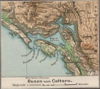
Busen von Cattaro
1 : 500000 Boka Kotorska
Buchta Boko-di-Kataro
Montenegro Kotor Seeschlacht
Umgebung von Cattaro

Umgebung von Cattaro

Cattaro.
from Spezialkarte der osterreichisch-ungarischen Monarchie.
Skize jenes Theiles des Kreises Cattaro in welchem die nördliche Gränze zu ersehen ist, wie sie gegenwärtig besteht, - und wie sie diplomatisch in der Richtung der Nr.24_33_34_35 und 36 bestehen sollte
1 : 84222 Boka Kotorska, Kotor (Region), Grenze Jabornigg von Altenfels, Rudolf
Carte du théâtre de l'insurrection des Bouches de Cattaro
1 : 143400 boka Kotorská (Černá Hora)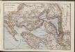
Bocche di Cattaro
1 : 150000 Montenegro Boka Kotorska
Carte, plan et vue des bouches de Cataro et de la forteresse de Castel-Novo, occupés par le Russes en 1806.
Kotor (Černá Hora) Köb, Kajetano Luther, Th.
Übersichtsblatt zum Kriegsspielplan der Umgebung von Cattaro
1 : 12500 Kotor (Černá Hora) K. u. k. militär-geographisches Institut
Mappa del Cordone Sanitario del Circolo di Cattaro
Kotor (Region) Cordon sanitaire , Relief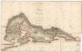
Karte der Bocche di Cattaro

Carte des BOUCHES de CATTARO et du MONTENEGRO
1 : 49000 boka Kotorská (Černá Hora) Traux, Maximilian de Stein, Carl Artaria et Comp.
Bojiště v Dalmácii
1 : 146000 Dalmácie jižní (Chorvatsko) Ed. Grégr
[Umgebung von Kotor]
Montenegro Kotor Umland
Trebinje und Risano.
from Spezialkarte der osterreichisch-ungarischen Monarchie.
[Umgebung von Molunat ; Politische Einteilung]
Kroatien Dalmatien Dalmatien Umland
Der Doppelhafen von Cattaro
1 : 100000 Boka Kotorska
Okolí Kotoru
1 : 140000 Kotor (Černá Hora) Bedřich Sandtner
Okolí Kotoru
1 : 140000 Kotor (Černá Hora) Fáborský, Jan B. Nipočić, Vasilij Bedřich Sandtner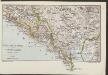
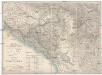
Südl. Dalmatien und Montenegro
1 : 600000 Kroatien Montenegro Dalmatien
Bezirke von Montengro
Kroatien, Montenegro
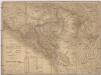
Generalkarte von Bosnien und Herzegovina

Generalkarte von Bosnien und der Hercegovina
1 : 300000 Bosnien-Herzegowina Montenegro
Crnagora
Černá Hora Hofmann, A.
Carte de la partie d'Albanie occupé par le Bacha de Scutari. le District des Montenegrins, et partie des territoires des Rep. de Venise, et de Raguse
1 : 490000 Albánie
Carte de la partie d'Albanie occupée par le Bacha de Scutari, le district des Montenegrins, et partie des territoires des Rep. de Venise, et de Raguse
1 : 490000 Albánie
Generalkarte von Zentraleuropa
Karta Crnegore
1 : 285000 Albánie Karacsay, Fedor de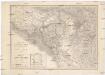
Karta Crnegore
1 : 285000 Albánie Karacsay, Fedor de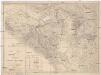
Karta Crnegore
1 : 285000 Albánie Karacsay, Fedor de