Maps of Fatih

Konstantinopel
1 : 150000 Istanbul, Umland
Plan de Constantinople, avec ses faubourgs en Europe et Scutari en Asie
Istanbul (Turecko) Merian, Matthaeus Levrault, F.G.
Prospect der Stadt und des Hafens von Constantinopel
Istanbul (Turecko) Nestler, Carl Gottfried
[Plan de Constantinople]
Nouvel atlas physique politique et historique de l'Empire ottoman et des états limitrophes en Europe, en Asie et en Afrique, en quarante feuilles Hellert, J.J. Bellizard, Dufour et Cie
Plan von Constantinopel mit den Vorstädten, dem Hafen, und einem Theile des Bosporus = Plan de Constantinople avec ses faubourgs, le port et une partie du Bosphore
1 : 15000 Stolpe, C Verlag von Lorentz & Keil
Plan von Constantinopel und seinen Vorstädten diesseits und jenseits des Bosporos
1 : 20000 Bospor (Turecko : průliv) Barbié du Bocage, Jean Denis C.A. Hartleben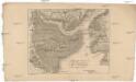
Grundriss von Constantinopel dessen Vorstadten und dem Häfen
1 : 59000 Istanbul (Turecko) Fáborský, Jan B. Schlitterlau, Friedrich Gottlob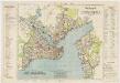
Plan d'ensemble de la ville d Constantinople
1 : 17500 Société anonyme ottomane d'études et d'entreprises urbaines Guédik-Pacha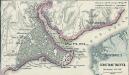
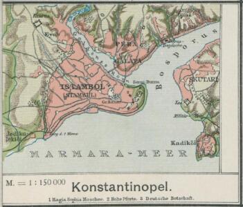
Constantinopel
1 : 100000 Konstantinopel
Konstantinopel
1 : 125000 Istanbul
Plan von Constantinopel und seinen Vorstädten diesseits und jenseits des Bosporos

Carte von Constantinopel
Istanbul (Turecko) Moltke, von Mahmud von Simon Schropp & Comp.
Constantinople = Stambol
1 : 22500000 Davies, Benjamin Rees Geoge Cox
Konstantinopel
Konstantinopel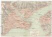
Konstatinopel
1 : 25000 Istanbul (Turecko)
Plan der Stadt Constantinopel nebst deren nächsten Angrenzungen = Plan de la ville de Constantinople ainsi que ses confins / von C.Stolpe ; in Stein gestochen von Jul. Straube
1 : 10000 titelvariant: Plan de la ville de Constantinople ainsi que ses confins; Annotatie geografische gegevens: De kaart toont de verspreiding van geloven over de stad Constantinopel C. Stolpe; Julius Albert Paul Straube 1832-1913 Pera : C. Stolpe
Graecia antiqua
starověké Řecko Geograph. Anstalt des Bibliograph. Instituts
Plan von Constantinopel
1 : 54400 Istanbul (Turecko) Bibliographisches Institut
Konstantinopel im Mittelalter
Istanbul (Turecko)
Map of Constantinople
1 : 28000 Wood Brothers
Konstantinopel und Umgegend
1 : 200000 Istanbul, Bosporus
Siège de Constantinople par Mohammed II.
Nouvel atlas physique politique et historique de l'Empire ottoman et des états limitrophes en Europe, en Asie et en Afrique, en quarante feuilles Hellert, J.J. Bellizard, Dufour et Cie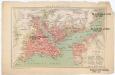
Konstantinopel
1 : 67200 Istanbul (Turecko) F.A. Brockhaus' geogr.-artist. Anstalt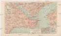
Konstantinopel
1 : 25000 Istanbul (Turecko) Bibliographisches Institut
Constantinopel und der Bosporus : Reduction nach der Aufnahme des Freiherrn v. Moltke auf 1⁄4 der Grösse des Originals
1 : 100000 gezeichnet von H. Kiepert Lith. v. C. Birck Berlin : Schropp
Die Umgegend von Constantinopel
1 : 600000 Istanbul
[Istanbul]
1 : 625000 Istanbul, Bosporus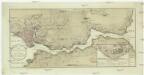
Plan de Constantinople et du Bosphore
1 : 62000 Bospor (Turecko : průliv)