Maps of Belgium
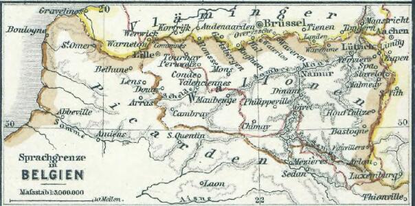
Sprachgrenze in Belgien
1 : 500000 Belgien Sprachgrenze
Belgium and the North of France (1938)
Belgium and the North East of France.
Carte de la Belgique avec les routes & distances des postes
1 : 1400000 J.F. Lange sculp. dessiné et gravée sous la direction de E. Maaskamp à Amsterdam : chez E. Maaskamp
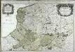
Parte meridionale des Pays Bas qui comprend les provinces de Brabant, Gueldre, Limbourg, Luxembourg, Hainaut, Namur, Flandre, Cambresis et Artois
1 : 620000 Artois (Francie) Janvier, Jean Denis Lattré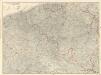
Ravensteins Deutsche Kriegskarten: Belgien und angrenzendes Frankreich von der ...

XXIII Tableau, uit: Carte chorographique des Pays-Bas Autrichiens / ... par le Comte de Ferraris ; gravée par L.A. Dupuis
1 : 86400 Annotatie: Lit.: Les militaires et la cartographie des Pays-Bas méridionaux et de la Principauté de Liège à la fin du XVIIe et au XVIII siècle / Claire Lemoine-Isabeau. - Bruxelles, 1984, p. 206-212; La cartographie au XVIIIe siècle et l'oeuvre du Comte de Ferraris (1726-1814) : colloque international, Spa, 8-11 sept. 1976. - Bruxelles, 1978; Met opdracht aan keizer Joseph II (bl.XVI); Met plattegrond van Brussel (bl. XXI), overzichtskaart (bl. XXII) en bladwijzer (bl. XXIII); Ontbreekt: bl. I-III en XXI; Voor aanwezige bladen zie overzichtsblad Ferraris, Johann Joseph; Dupuis, L. A. [S.l. : s.n.]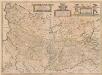
Picardia Vera Et Inferior [Karte], in: Novus atlas absolutissimus, Bd. 4, S. 50.
1 Karte aus Atlas Janssonius Offizin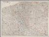
[Recto], uit: Kriegskarte von Belgien und angrenzendem Frankreich
1 : 300000 Frankfurt a.M. : Ravenstein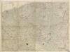
Kriegskarte von Belgien und angrenzendem Frankreich
Le gouvernement general de Picardie
1 Karte auf 2 Blättern : Kupferdruck ; 52 x 78 cm Jaillot chez H. Iaillot joignant les grands Augustins aux 2. globes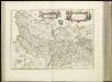
[17][17] Nova Picardiae tabula, uit: Atlas sive Descriptio terrarum orbis
Annotatie: Gedigitaliseerde versie. Amsterdam. Heiloo : Picturae (vervaardiger), 2015. tiff-bestand. Gedigitaliseerd: 07-01-2015; Origineel: Universiteitsbibliotheek Vrije Universiteit (XL.05127.-) ; Netherlands; Titelpagina ontbreekt Wit, Frederik de Amsterdam : Frederick de Wit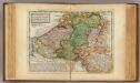
Flanders or the Austrian Netherlands.
1 : 1400000 Moll, Herman, d. 1732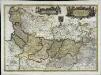
Nova Picardiæ tabula
1 Karte : Kupferdruck ; 38 x 53 cm Wit Frederick de Wit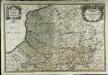
Le gouvernement general de Picardie
1 Karte auf 2 Blättern : Kupferdruck ; 52 x 78 cm Jaillot; Sanson chez H. Iaillot joignant les grands Augustins aux 2. globes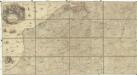
Carte des Pais Bas
1 : 202000 Bourbonsko (Francie) Le Rouge Le Rouge
Picardia vera et inferior
1 : 578000 Pikardie (Francie) Janssonius, Johannes sumptibus Ioannis Ianßonii
Deutsch - Französischen Kriegsschauplatzes

[Recto], uit: Carte physique, politique et administrative de la Belgique : contenant les noms de toutes les communes, des hameaux principaux, les chemins de fer, routes, canaux etc, etc.
1 : 320000 Annotatie: Met opdracht aan Leopold III Bruxelles : Dosseray [etc.]
Die Königliche Niederland Bestehende inn X. Provincien
1 : 3000000 Mollova mapová sbírka Bodenehr, Gabriel Bodenehr, Gabriel
NOVA | PICARDIÆ | TABULA.
[Amsterdam : Joan Blaeu]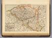
Belgium, Luxemburg.
1 : 1000000 Andree, Richard; Times (London, England)
Il governi della Fiandra francese, d'Artois, di Picardia, e del Boulonois
1 Karte : Kupferdruck ; 28 x 36 cm Zatta presso Antonio Zatta
Carte routiere de la Belgique

Carte generale de Picardie
1 Karte : Kupferdruck ; 25 x 35 cm Merian Caspar Merian
Præfectura Picardiæ
1 Karte : Kupferdruck ; 47 x 58 cm Valck; Valck G. und L. Valck
Le Gouvernement General De Picardie, ou sont Le Pays Reconquis, Le Boulenois, Le Ponthieu [...] [Karte], in: Atlas nouveau, contenant toutes les parties du monde [...], Bd. 1, S. 112.
1 Karte aus Atlas Sanson, Nicolas Jaillot, Alexis Hubert und Mortier, Pieter
Picardia vera et inferior
1 : 570000 Pikardie (Francie) Charnacé, Hercule de sumptibus Henrici Hondii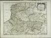
Gouvernement general de la Picardie, Artois, Boulenois, et pays reconquis [et]c
1 Karte : Kupferdruck ; 38 x 51 cm Sanson; Mariette; Somer chez Pierre Mariette rue St. Jacques a l'esperance
Carte du GOVVERNEMENT GENERAL DE PICARDIE
1 : 380000 Amiens-oblast (Francie) Delisle, Guillaume par les Heritiers de Homan