Maps of Europe

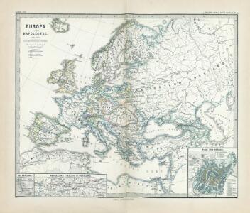
Europa zur Zeit Napoleon's I. (um 1810)
1 : 15000000 Europa Napoleon I., Frankreich, Kaiser
Europa nach dem Wiener Congress 1815
1 : 15000000 Europa
Europa um die Mitte des Vierzehnten Jahrhunderts
1 : 15000000 Europa
[Karte von Europa, Zur Übersicht der Wärme-Verbreitung in diesem Erdtheile]
Erster Band, enthaltend in vier Abtheilungen die Erscheinungen der anorganischen Natur: 1. Meteorologie und Klimatographie. 2. Hydrologie und Hydrographie. 3. Geologie. 4. Tellurischer Magnetismus Humboldt, Alexander von Verlag von Justus Perthes
Machtverhältnisse der Europ. Staaten
1 : 14000000 Übersichtskarte Block, Maurice Justus Perthes
Europa vom Westfälischen Frieden 1648 bis zur Zersplitterung der grossen spanischen Monarchie 1700 (Zeitraum der Übermacht Frankreichs)
1 : 15000000 Europa, Westfälischer Friede
Europa ad magnae Europae Gerardi Mercatoris P. imitationem [...] [Karte], in: Gerardi Mercatoris Atlas, sive, Cosmographicae meditationes de fabrica mundi et fabricati figura, S. 61.
1 Karte aus Atlas Mercator, Gerhard Montanus, Petrus
Europa
Schul-Atlas in 36 Karten Völter, Daniel Verlag der J.M. Dannheimer'schen Buchhandlung
Europa
Atlas der Geologie Zittel, K.v. ; Berghaus, Hermann Justus Perthes
Völkerkarte von Europa
1 : 36000000 Europa Ethnische Gruppe
Europa
[Allgemeiner Atlas über alle Theile der Erde in 29 Blättern] Ziegler, Jakob Melchior Top. Anstalt v. J. Wurster u. Comp.
Europa um 1740
1 : 15000000 Europa
Europa
Geographischer Atlas über alle Theile der Erde Ziegler, Jakob Melchior Verlag von Dietrich Reimer
Europa zur Zeit des dritten Kreuzzuges 1190
1 : 15000000 Europa Kreuzzug <1189-1192>
Europa, Staatenkarte
1 : 25000000 Europa
[Karte von Europa, Zur Übersicht der Regen-Verhältnisse in diesem Erdtheile]
Erster Band, enthaltend in vier Abtheilungen die Erscheinungen der anorganischen Natur: 1. Meteorologie und Klimatographie. 2. Hydrologie und Hydrographie. 3. Geologie. 4. Tellurischer Magnetismus Humboldt, Alexander von Verlag von Justus Perthes
Europa Übersicht der politischen Verhältnisse und Hauptverkehrswege
1 : 20000000 Europa Verkehrsnetz
Europa. Staaten
1 : 24000000 Europa Politische Geografie
[Übersicht der Verbreitung der wichtigsten Kultur-, Baum- und Strauchgewächse in Europa]
Zweiter Band, enthaltend in vier Abtheilungen die Vertheilung der Organismen: 5. Pflanzen-Geographie, 6. Thier-Geographie, 7. Anthropographie, 8. Ethnographie Humboldt, Alexander von Verlag von Justus Perthes
[Neuer Atlas der ganzen Erde nach den neuesten Bestimmungen ... : II.] Europa
Entworfen und gezeichnet von F.W. Streit H. Leutemann sc. Leipzig : J.C. Hinrichs'sche Buchhandlung
Europa nach seinen ethnographischen Verhältnissen in der Mitte des XIX Jahrhunderts
1 : 15000000 Europa ethnische Gruppe
Europa ad magnae Europae Gerardi Mercatoris P. imitationem [...] [Karte], in: Atlas, sive, Cosmographicae meditationes de fabrica mundi et fabricati figura, S. 65.
1 Karte aus Atlas Mercator, Gerhard
Europa Post Bellum Triginta Annorum. (1650-1700)
Europa Westfälischer Friede
Völkerkarte von Europa
1 : 36000000 Europa Ethnische Gruppe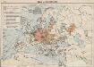
Das Deutschtum in Europa
1 : 36000000 Europa Ethnische Gruppe, Deutsche
Hauptverbindungslinien von Europa als Mittelpunkt des Welverkehrs
Geographischer Atlas über alle Theile der Erde Ziegler, Jakob Melchior Verlag von Joh. Wurster um Comp.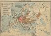
Das Deutschtum in Europa
1 : 36000000 Europa Ethnische Gruppe, Deutsche
Europa
Adolf Stieler's Handatlas über alle Theile der Erde und über das Weltgebäude Stieler, Adolf Justus Perthes
Europe.
1 : 21542400 Lucas, Fielding Jr.