Maps of Poland

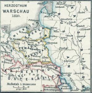
Herzogthum Warschau 1810
1 : 20000000 Herzogtum Warschau
Herzogthum Warschau 1808
1 : 20000000 Herzogtum Warschau
Regnum Poloniae eiusque confinia
1 : 11100000 1 Karte : Kupferdruck ; 13 x 17 cm Weigel, Johann Christoph [Johann Christoph Weigel]
Reise Charte durch das Königreich Polen mit allen darzu gehörigen Laendern / verfertiget von JG. S
1 : 9300000 1 Karte : Kupferdruck ; 16 x 21 cm, Bildgr. 17 x 25 cm Schreiber, Johann Georg [J. G. Schreiber]
Regni Poloniae magnique ducatusq. Lithuaniae nova et exacta tabula
1 : 3130000 Bělorusko Homann, Johann Baptist Starowolski, Szymon Homannovi dědicové
REGNI POLONIAE MAGNIQUE DUCATUS LITHUANIAE Nova et exacta tabula
1 : 3200000 Bělorusko Homann, Johann Baptist Starowolski, Szymon Homannovi dědicové
Regni Poloniae magnique ducatusq. Lithuaniae nova et exacta tabula
1 : 3130000 Bělorusko Homann, Johann Baptist Starowolski, Szymon Homann Erben
Regni Poloniae magnique ducat[us] Lithuaniae nova et exacta tabula
1 : 3041000 Bělorusko Homann, Johann Baptist Starowolski, Szymon â Iohanne Bapt. Homanno
Ostmitteleuropa 1989
Ostmitteleuropa Kunz, Andreas ; Treiling, Thomas
Carte von Polen und einen grossen Theil der angrenzenden Laender
1 : 1300000 Evropa střední a východní Rendziny, Stanislaus Gilly Tranquillo Mollo
Poland.
1 : 6300000 Moll, Herman, d. 1732
Carte des partages de la Pologne en 1772, 1793 et 1795
1 Karte : Typometrie ; 24 x 28 cm Haas chez G. Haas et chez J. Decker imprimeur libraire =Johann Heinrich Deckers Erben?
Carte des partages de la Pologne en 1772, 1793 et 1795
1 Karte : Typometrie ; 24 x 28 cm Haas chez G. Haas et chez J. Decker imprimeur libraire =Johann Heinrich Deckers Erben?
Poland: Density
1 : 3000000 Series of maps on various aspects of Poland. Density. Number of inhabitants per square kilometre. War Office
[Geschichtlich-geographische Entwickelung des Zuwachses und der Abnahme des polnischen Reiches vom Jahre 992 bis zum Jahre 1831, dargestellt in fünf Karten] : V. Karte der Wiederherstellung Polens, 1807-1831
1 : 4800000 entw. u. gez. durch F.A. von Witzleben [Berlin] : [Reimer]
Poland: Poles (excluding Jews)
1 : 3000000 Series of maps on various aspects of Poland. Poles (excluding Jews). Kingdom of Poland (1897) an Galicia (1900). Distribution of Poles, showing minorities. War Office
Poland: Language. No.2
1 : 3000000 Series of maps on various aspects of Poland. Distribution of languages according to various authorities. War Office
Poland: Jews
1 : 3000000 Series of maps on various aspects of Poland. Distribution of Jewish minorities. War Office
Ostmitteleuropa 1991
Ostmitteleuropa Kunz, Andreas ; Treiling, Thomas
Poland: Language. No.1
1 : 3000000 Series of maps on various aspects of Poland. Languages in 1910-1913. War Office
Ostmitteleuropa 1815
Ostmitteleuropa Kunz, Andreas ; Johnen, Bettina ; Moeschl, Joachim Robert
[Geschichtlich-geographische Entwickelung des Zuwachses und der Abnahme des polnischen Reiches vom Jahre 992 bis zum Jahre 1831, dargestellt in fünf Karten] : IV. Karte der 3 Theilungen Polens von 1773-1795
1 : 4800000 entw. u. gez. durch F.A. von Witzleben [Berlin] : [Reimer]
Ostmitteleuropa 2003
Ostmitteleuropa Kunz, Andreas ; Treiling, Thomas
[Geschichtlich-geographische Entwickelung des Zuwachses und der Abnahme des polnischen Reiches vom Jahre 992 bis zum Jahre 1831, dargestellt in fünf Karten] : II. Karte von Polen unter dem Jagellonen, 1386-1572
1 : 4800000 entw. u. gez. durch F.A. von Witzleben [Berlin] : [Reimer]
Poland: Lithuanians, Little Russians and Czechs
1 : 3000000 Series of maps on various aspects of Poland. Distribution of Lithuanians, Little Russians and Czechs, showing minorities. War Office
Poland: Poles
1 : 3000000 Series of maps on various aspects of Poland. Distribution of Poles showing minorities. War Office
Mapa rozmieszczenia gleb na ziemiach polskich
1 : 6300000 Polen Geologie Arct, Michał
[Geschichtlich-geographische Entwickelung des Zuwachses und der Abnahme des polnischen Reiches vom Jahre 992 bis zum Jahre 1831, dargestellt in fünf Karten] : III. Karte von Polen von dem Aussterben der Jagellonen bis zur ersten Theilung, 1572-1772
1 : 4800000 entw. u. gez. durch F.A. von Witzleben [Berlin] : [Reimer]
Volker und Reiche der Slaven zwischen Elbe und Don bis 1125.
1 : 5000000 Spruner von Merz, Karl