Maps of Balkan Pen.
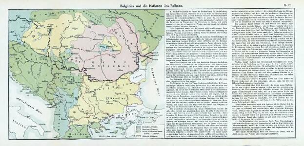
Nr. 17. Bulgarien und die Nationen des Balkans
Balkanhalbinsel, Bulgarien
Schul-Atlas für die alte Erdbeschreibung : zur allgemeinen Schul-encyclopädie gehörig
J. H. Campe Zusammensetzung und Zeichnung von [...] Dufour, unter Leitung von Heusinger ; gestochen von Frentzel. Braunschweig : Schulbuchhandlung
Turkey in Europe.
1 : 2533000 Johnston, Alexander Keith
Turkey in Europe.
1 : 4000000 Colton, G.W.
Etats Danubiens.
1 : 2500000 Vivien St Martin, L.
Turkey in Europe.
1 : 3674880 Burr, David H., 1803-1875
Turkey in Europe.
1 : 2533000 Johnston, W. & A.K.
Turkey In Europe.
1 : 4942080 Tallis, J. & F.
Hvngariae ampliori significatu et veteris vel methodicae complexae regna: Hvngariae propriae, Croatiæ, Dalmatiae, Bosniae, Serviae, Bvlgariae, Cvmaniae, principatvm: Transylvaniae, despotatvs: Walachiae, Moldaviae [exclusis ab eadem alienatis Galitia et Lvdomiriria] in suas provincias ac partes divisae et quo ad imperanies ex Avstriacis, Tvrcis et Venetis distinctae [juncta tamen propter comoditatem Romania vel Romelia tvrcica] tabvla
1 Karte : Kupferdruck ; 45 x 57 cm Haas curantibus Homannianis Heredibus
Map of the Balkan States
Balkanhalbinsel
Die Transhumanz der dakorumänischen, aromunischen, meglenorumänischen und istrorumänischen Hirten
Balkanhalbinsel Transhumanz, Walachen Willing, P.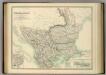
Turkey in Europe.
1 : 2533000 Johnston, Alexander Keith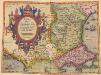
Romaniae, (quae olim Thracia dicta) Vicinarumque Regionum, Uti Bulgariae, Walachiae, Syrfiae, Etc. Descriptio. [Karte], in: Theatrum orbis terrarum, S. 283.
1 Karte aus Atlas Ortelius, Abraham

The North Part of Turky in Europe Slavonia &c
1 : 5500000 Mollova mapová sbírka Moll, Herman Moll, Hermann
Hvngariae ampliori significatu et veteris vel Methodicae, complexae Regna: Hvngariae Propriae, Croatia, Dalmatiae, Bosniae, Serviae, Bvlgariae, Cvmaniae, Principatvm: Transsylvaniae, Despotatvs: Walachiae, Moldaviae, exclusis ab eadem alienatis Galitia et Lvdomiriria in suas Provincias ac partes divisae et quoad Imperantes ex Avstriacis, Tvrcis et Venetis distinctae juncta tamen propter commoditatem Romania vel Romelia Tvrcica Tabvla ex recentissimis pariter et antiquissimis relationibus et monumentis concinnata, ac secundum leges Projectionis Stereographicae legitimae descrita a
1 : 2500000 Mollova mapová sbírka Hase, Johann Matthias Homann, Johann Baptista - dědici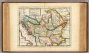
The north part of Turkey in Europe, Slavonia &c.
1 : 5500000 Moll, Herman, d. 1732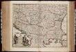
Nova totius Hungariae, Transilvaniae, Serviae, Romaniae, Bulgariae, Walachiae, Moldaviae, Sclavoniae, Croatiae, Bosniae, Dalmatiae, maximaeq[ue] partis Danubii fluminis, descriptio / emendata a F. de Wit
1 : 2600000 Annotatie: Tekst impressum in het Nederlands; Rechtsboven: 21; Kaart toont Hongarije, omliggende landen en een belangrijk deel van de loop van de Donau; Origineel is Blad 129 in atlas factice; Annotatie geografische gegevens: Schaalstok linksonder cartouche: Milliaria Germanica communia 15 uni gradui = Gemeene Duytsche Mylen van 15 in een graedt Frederick de Wit 1630-1706 Amsterdam : gedruckt by Frederick de Wit inde Kalverstraet by den Dam inde Witte Pascaert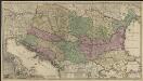
Novissima tabula regni Hungariae et regionum quondam ei unitarum ut Transilvaniae, Valachiae, Moldaviae, Serviae, Romaniae, Bulgariae, Bessarabiae, Croatiae, Bosniae, Dalmatiae, Slavoniae, Morlachiae et reipublicae Ragusanae : accedit pars magna dominii Veneti [...]
1 : 2000000 auctore Reinier & Josua Ottens geographe Amstelodamensi J. Keyser sculpsit Te Amsterdam : by Reinier & Iosua Ottens [...]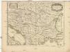
Le royaume de Hongrie
1 : 2200000 Evropa jihovýchodní Jaillot, Alexis-Hubert H. Iaillot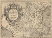
Romaniae, (quae olim Thracia dicta) Vicinarumque Regionum, Uti Bulgariae, Walachiae, Syrfiae, Etc. Descriptio. [Karte], in: Theatrum orbis terrarum, S. 378.
1 Karte aus Atlas Ortelius, Abraham Vrients, Jan Baptista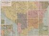
Professor W. Liebenow's Kriegskarte der Balkanstaaten
1 : 1250000 balkánské země Liebenow, Wilhelm Gea Verlag
Hungariae ampliori significatu...

Regnum Hungariae, in quo continentur Regiones
1 : 5900000 Mollova mapová sbírka Bruggen, Johann van der Brugge, Johannes van der
Regnum Hungariae, in quo continentur Regiones :
1 : 5900000 Mollova mapová sbírka Bruggen, Johann van der Brugge, Johannes van der
Composite: Europaischen Turkei.
1 : 1580000 Handtke, Friedrich H.
Hungaria cum reliqua modernicum Turcis belli sedes
1 : 3600000 Balkánský poloostrov Biberger, Johann Ulrych