Maps of Europe

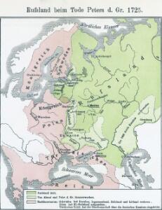
Russland beim Tode Peters d. Gr. 1725
Russland
Russland beim Tode Katharinas II. 1796
Russland
Russland 1682-1762
1 : 18000000 Russland Expansion
Russland
1 : 15000000 Evropa východní Kocen, Blaž Eduard Hölzel
Ost Europa
1 : 12500000 Russland / Europäischer Teil
Carte de la Pologne à son apogee, sous Sigismond-Auguste, en face du Principat de Russie sous le czar Ivan IV, vers l’an 1570 de notre ère
Polen Russland Polen-Litauen Zygmunt August
Skandinavien und Rußland
1 : 18000000 Skandinavien, Osteuropa
Russland
1 : 36000000 Russland / Europäischer Teil
Des Russischen Reichs Europäischer Theil
Stieler's Hand-Atlas Stieler, Adolf bei Justus Perthes
Sarmatische Tiefebene
Osteuropa, Ostmitteleuropa
Kompas omniumkaart bevattende: Noorwegen, Zweden, Finland, Europeesch Rusland, Europ. en Aziatisch Turkije, Irak, Middell. Zeegebied, en Suez
1 : 5500000 Den Haag : Kompas
Ruszland
1 : 12000000 Russland / Europäischer Teil
Rußland
1 : 18000000 Russland / Europäischer Teil
Europaeisches Russland mit Polen
Geographischer Atlas über alle Theile der Erde Ziegler, Jakob Melchior Verlag von Joh. Wurster um Comp.
Skandinavien und Rußland
1 : 18000000 Skandinavien, Osteuropa
Eastern Europe.
1 : 14495100 Fisher, Richard Swainson
Tabula Russiae ex autographo, quod delineandum curavit Foedor filius Tzaris Boris desumta [...] [Karte], in: Theatrum orbis terrarum, sive, Atlas novus, Bd. 1, S. 67.
1 Karte aus Atlas Blaeu, Joan Blaeu, Willem Janszoon
Russland beim Tode Iwans II. 1584
Russland
Russland
Neuer Handatlas über alle Theile der Erde Kiepert, Heinrich Verlag von Dietrich Reimer
Novissima Russiae Tabula [Karte], in: Gerardi Mercatoris et I. Hondii Newer Atlas, oder, Grosses Weltbuch, Bd. 1, S. 124.
1 Karte aus Atlas Mercator, Gerhard und Hondius, Jodocus Jansson, Jan
Europaeisches Russland
Plastischer Schul-Atlas über alle Theile der Erde : in 24 Karten Woldermann, G Verlag von P. Eckerlein
Das europäische Russland
Schul-Atlas in 36 Karten Völter, Daniel Verlag der J.M. Dannheimer'schen Buchhandlung
Tabula Russiae ex mandato Foedor Borissovitsj delineata ... Magno domino, Tzari et magno duci Michäeli Foedrowits omnium Russorum autocratori... dedicata a Nicolao Ioannis Piscatore
1 : 10000000 Annotatie: Met breedte- en lengtegraden; Origineel is Blad 136 in atlas factice; Annotatie geografische gegevens: 2 schaalstokken: Wirst seu milliaria Russica en Milliaria Germanica; Inzet: Celeberrima ingens et imperialis civitas Moscua; Russche Narva sive Ivane-gorod; Archangel sive Archangelscka-goroda; Curia Imperatoris Russi appellata Kremelena-gorod; Hypocausta Russorum; Molendina Russorum Fjodor Borissovitsj Godoenov 17e E.; Claes Jansz. Visscher 1586/1587-1652 [S.l. : C.J. Visscher Excudebat]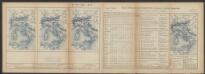
Tabula Russiae [...] [Karte] Moscua ad Architypum Foedori Borißowitsi [Planvedute, Karte], in: Le théâtre du monde, ou, Nouvel atlas contenant les chartes et descriptions de tous les païs de la terre, Bd. 1, S. 67.
1 Karte aus Atlas Blaeu, Willem Janszoon und Blaeu, Joan Blaeu, Willem Janszoon
Rußland
1 : 18000000 Russland / Europäischer Teil
Novissima Russiae Tabula [Karte], in: Novus atlas absolutissimus, Bd. 1, S. 70.
1 Karte aus Atlas Janssonius Offizin
Bodenbenutzung und Industrie
Russland / Europäischer Teil Industrie, Bodennutzung
Europäisches Russland
1 : 16000000 Russland / Europäischer Teil
Tabvla Rvssiæ / ex autographo, quod delineandum curavit Foedor filius tzaris Boris desumta; et ad f
1 : 9000000 1 Karte : Kupferdruck ; 41 x 53 cm Fëdor excusum apud Guiljelmum Blaeu