Maps of Mediterranean Sea

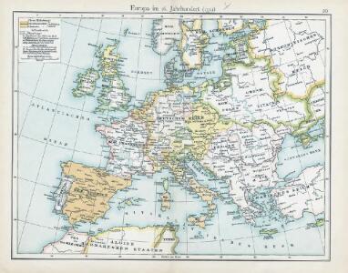
20. Europa im 16. Jahrhundert (1559)
1 : 15000000 Europa
A map of the western part of the Roman empire
1 Karte : Kupferdruck ; 39 x 46 cm s.n.
Europe Centrale en 1920
1 : 4200000 titelvariant: Nouvelle carte de l'Europe Centrale; Annotatie: Titel linksboven: Nouvelle carte de l'Europe Centrale Paris : Taride
Europa im 16. Jahrhundert (1559)
1 : 15000000 Europa
23. Europa im 17. und 18. Jahrhundert (1740)
1 : 15000000 Europa
Europa im 17. und 18. Jahrhundert (1740)
1 : 15000000 Europa
Roman Empire, Greece.
1 : 17000000 Mitchell, Samuel Augustus

Eisenbahn- Post- und Dampfschiffahrts-Karte von Europa
1 : 8000000 Evropa Denk, L. Lith. Anst. v. L. Mohn's Witwe
Österreich-Ungarn und Bosnien-Hercegovina
Eberle, Joseph
Incursions of barbarians.
1 : 23500000 Mitchell, Samuel Augustus
Nieuwste oorlogskaart van Europa
1 : 6000000 A[mster]dam : Meulenhoff
9-10. Linee di comunicazione, Europa centrale, Mediterranea.
1 : 8000000 Touring club italiano
Europa 1668
Europa Kunz, Andreas ; Moeschl, Joachim Robert
Europa 31.12.1806
Europa Kunz, Andreas ; Moeschl, Joachim Robert
Carte d'Europe indiquant le canal maritime de l'océan à la Méditerranée
1 : 16000000 Perrin, Maurice [Paris] : [éditeur inconnu]
Europa 1699
Europa Kunz, Andreas ; Moeschl, Joachim Robert

Europa 1721
Europa Kunz, Andreas ; Moeschl, Joachim Robert
Europa 1881
Europa Kunz, Andreas ; Röss, Wolf ; Moeschl, Joachim Robert
Europa 1861
Europa Kunz, Andreas ; Röss, Wolf ; Moeschl, Joachim Robert
Europa 1555
Europa Kunz, Andreas ; Moeschl, Joachim Robert
Europa 1993
Europa Kunz, Andreas ; Moeschl, Joachim Robert
Europa Prima Nova Tabula [Karte], in: Claud. Ptolemaeus. Geographia lat. cum mappis [...], S. 332.
1 Karte aus Atlas Münster, Sebastian [und Ptolemaeus, Claudius]
Europa 1804
Europa Kunz, Andreas ; Moeschl, Joachim Robert
Invasion des Barbares.
Andriveau-Goujon, J.
Europa 1772
Europa Kunz, Andreas ; Moeschl, Joachim Robert
Europa 1500
Europa Kunz, Andreas ; Moeschl, Joachim Robert
Paasche's Frontenkarte, Nr. 11 Europäische Kriegsschauplätze