Maps of Mureș

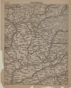
Siebenbürgen
1 : 600000 Siebenbürgen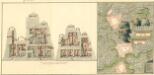
Plan deren Bergwerg Nagiay: i Offi und Bedas
Mollova mapová sbírka Geyer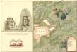
Plan des Bergwergs Igen.
Mollova mapová sbírka Geyer
Nyaradto und Nagy-Kend.
from Spezialkarte der osterreichisch-ungarischen Monarchie.
Besztercze [Bistritz] (Ungarn).
from Spezialkarte der osterreichisch-ungarischen Monarchie.
Bistritz
1 : 75000 Bistriţa (Rumunsko) K. u. k. militär-geographisches Institut
Maros-Vasarhely.
from Spezialkarte der osterreichisch-ungarischen Monarchie.
Gyeres.
from Spezialkarte der osterreichisch-ungarischen Monarchie.
Projet-Plan von der erbauten grossen St[r]asse, die von Bistritz aus Siebenbürgen, über den Beg Zimbrosa nach der Buccovina in den Jahren 1780zig ist erbauet worden, um den Weeg über die Kukuraza zu vermeiden
1 : 90500 Bistriţa-Năsăud (Rumunsko : judet)
Magyar-Lapos und Makod.
from Spezialkarte der osterreichisch-ungarischen Monarchie.
Szovata.
from Spezialkarte der osterreichisch-ungarischen Monarchie.
Kolozsvar [Klausenburg].
from Spezialkarte der osterreichisch-ungarischen Monarchie.
Torda.
from Spezialkarte der osterreichisch-ungarischen Monarchie.
Nagy-Enyed.
from Spezialkarte der osterreichisch-ungarischen Monarchie.
Alparet [Olpret].
from Spezialkarte der osterreichisch-ungarischen Monarchie.
Besztercze
1 : 75000 Bistritz, Bistriţa-Năsăud
Maros-Ludas
1 : 75000 Luduş, Judeţ Mureş
Szamosojvár
1 : 75000 Gherla, Judeţ Klausenburg
Gyéres
1 : 75000 Câmpia Turzii, Judeţ Klausenburg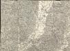
Maros Vásárhely
1 : 75000 Neumarkt, Maros
Nyárádtö
1 : 75000 Judeţ Mureş
Szék
1 : 75000 Sic, Judeţ Klausenburg
Szász-Régen
1 : 75000 Reghin
Maros-Ludas.; Spezialkarte der osterreichisch-ungarischen Monarchie.
from Spezialkarte der osterreichisch-ungarischen Monarchie. Austro-Hungarian Monarchy. Militärgeographisches Institut.,
Szasz-Regen.; Spezialkarte der osterreichisch-ungarischen Monarchie.
from Spezialkarte der osterreichisch-ungarischen Monarchie. Austro-Hungarian Monarchy. Militärgeographisches Institut.,
Szek und Mocs.; Spezialkarte der osterreichisch-ungarischen Monarchie.
from Spezialkarte der osterreichisch-ungarischen Monarchie. Austro-Hungarian Monarchy. Militärgeographisches Institut.,
Szamosujvar.; Spezialkarte der osterreichisch-ungarischen Monarchie.
from Spezialkarte der osterreichisch-ungarischen Monarchie. Austro-Hungarian Monarchy. Militärgeographisches Institut.,
Plan von Bergwerg Szromova
Mollova mapová sbírka Geyer
Óradna
1 : 75000 Rodna, Rodna (Region)