Maps of Region of Banská Bystrica
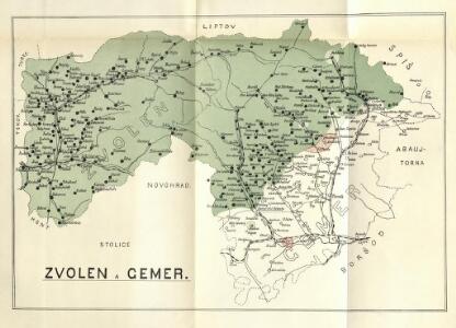
Stolice Zvolen a Gemer
Komitat Altsohl, Komitat Gemer, ethnische Gruppe
Bez titulu: mapy slovenských krajů

Kraj banskobystrický

Československo v mapách

Zipser Comitat
1 : 280000 Spiš (Slovensko)
C. Gömöriensis
Slowakei Komitat Gemer
Rima-Szombat 135, uit: Special-Karte von Mittel-Europa / nach amtlichen Quellen bearbeitet von W. Liebenow
1 : 300000 titelvariant: W. Liebenow's Mittel-Europa; Annotatie: Titel boven de bladen: W. Liebenow's Mittel-Europa Johannes Wilhelm Liebenow 1822-1897 Frankfurt a. M. : Ludwig Ravenstein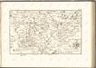

Zólyom vármegye térképe
1 : 300000 Zvolen (Slovensko : oblast) Kogutowicz, Manó Magyar Földrajzi Intézet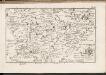
C. Tornensis
Ungarn Komitat Torna
Gömör vármegye és a' vele törvényesen egyesült Kis-Honti kerület
1 : 240000 Gemer (Slovensko : oblast) Ráisz, Christ. Benedicti, Hieronymus Görög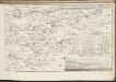
C. Zoliensis
Slowakei Komitat Altsohl
Sohler Comitat
1 : 280000 Zvolen-oblast (Slovensko)
Sohler Comitat
1 : 280000 Zvolen-oblast (Slovensko)
Sohler Comitat
1 : 280000 Zvolen (Slovensko : oblast)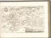

Mappa Comitatus Zoliensis
1 : 160000 Mollova mapová sbírka Mikoviny, Sámuel Nicolaï, Georg David Christoph Straub, Paul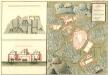
Plan des Niderhandels Buckons
Mollova mapová sbírka Geyer
Mappa Comitatvs Neogradiensis Methodo Astronomico-Geometrica concinnata
1 : 166600 Mollova mapová sbírka Mikoviny, Sámuel Nicolaï, Georg David Christoph
Mappa comitatus Zoliensis
1 : 165000 Zvolen-oblast (Slovensko) Mikoviny, Sámuel Nicolai, Georg David Christoph
Stolice Novohrad
Komitat Nógrád ethnische Gruppe
Slovenské rudohorie
Lučenec a okolie

Nagy-Rocze und Rimm-Banya (Ungarn).
from Spezialkarte der osterreichisch-ungarischen Monarchie.
Dettva und Libethen (Ungarn).
from Spezialkarte der osterreichisch-ungarischen Monarchie.
Losoncz (Ungarn).
from Spezialkarte der osterreichisch-ungarischen Monarchie.
Rimavská Sobota, Číž – Domica

Rosenau und Szilas.
from Spezialkarte der osterreichisch-ungarischen Monarchie.