Maps of Pontic Steppe

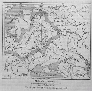
Die Slaven nördlich von der Donau um 900
1 : 21000000 Osteuropa Slawen
Osteuropa 2003
Osteuropa Kunz, Andreas ; Treiling, Thomas ; Moeschl, Joachim Robert
Osteuropa 1772
Osteuropa Kunz, Andreas ; Treiling, Thomas ; Moeschl, Joachim Robert
Osteuropa 1926
Osteuropa Kunz, Andreas ; Treiling, Thomas ; Moeschl, Joachim Robert
Osteuropa 1954
Osteuropa Kunz, Andreas ; Treiling, Thomas ; Moeschl, Joachim Robert
Osteuropa 1878
Osteuropa Kunz, Andreas ; Treiling, Thomas ; Moeschl, Joachim Robert
Osteuropa 1795
Osteuropa Kunz, Andreas ; Treiling, Thomas ; Moeschl, Joachim Robert
Osteuropa 1783
Osteuropa Kunz, Andreas ; Treiling, Thomas ; Moeschl, Joachim Robert
Osteuropa 1921
Osteuropa Kunz, Andreas ; Treiling, Thomas ; Moeschl, Joachim Robert
Osteuropa 1949
Osteuropa Kunz, Andreas ; Treiling, Thomas ; Moeschl, Joachim Robert
Osteuropa 1812
Osteuropa Kunz, Andreas ; Treiling, Thomas ; Moeschl, Joachim Robert
Osteuropa 1914
Osteuropa Kunz, Andreas ; Treiling, Thomas ; Moeschl, Joachim Robert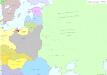
Osteuropa 1937
Osteuropa Kunz, Andreas ; Treiling, Thomas ; Moeschl, Joachim Robert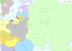
Osteuropa 1922
Osteuropa Kunz, Andreas ; Treiling, Thomas ; Moeschl, Joachim Robert
Osteuropa 1863
Osteuropa Kunz, Andreas ; Treiling, Thomas ; Moeschl, Joachim Robert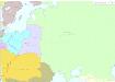
Osteuropa 1793
Osteuropa Kunz, Andreas ; Treiling, Thomas ; Moeschl, Joachim Robert
Osteuropa beim Regierungsantritte Peters des Gr. 1682
Osteuropa Peter I., Russland, Zar
Russland in den Jahren von 900 bis 966
1 : 15000000 Russland / Europäischer Teil
Osteuropa um das Jahr 1250
Osteuropa
Osteuropa beim Regierungsantritte Peters des Gr. 1682
Osteuropa Peter I., Russland, Zar
Russland nach seinen kirchlichen Verhältnissen bis zum XVI. Jahrhundert
1 : 15000000 Russland Kirchengeschichte
Osteuropa um das Jahr 1250
Osteuropa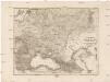
Dacia or., Sarmatia, Caucasus, Scythia int. Imaum
1 : 800000 Dácie Reichard, Christian Gottlieb Campius, D. a D. Campio
Osteuropa 1991
Osteuropa Kunz, Andreas ; Treiling, Thomas ; Moeschl, Joachim Robert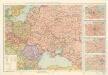
Soubor zájezdových map – Svaz Sovětských Socialistických Republik

Russland von der Zerstörung Kiews durch Batu, 1240, bis zum Übergang des Grossfürstenthums nach Moskau
1 : 15000000 Russland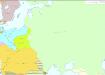
Osteuropa 1830
Osteuropa Kunz, Andreas ; Treiling, Thomas ; Moeschl, Joachim Robert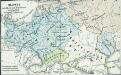
Slawen nördlich der Donau 850 bis 900
1 : 24000000 Ostmitteleuropa Slawen
Osteuropa 1815
Osteuropa Kunz, Andreas ; Treiling, Thomas ; Moeschl, Joachim Robert