Maps of Scandinavia

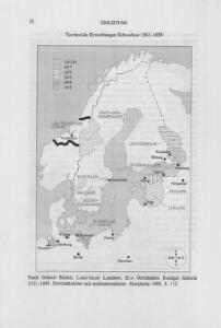
Territoriale Erwerbungen Schwedens 1561-1658
Schweden Expansion
Prussia Sweden Norway And Denmark.
1 : 7603200 Johnson, A.J.
Neueste Karte von Schweden und Norwegen
Grosser Hand-Atlas über alle Theile der Erde in 170 Karten Meyer, J. Verlag des Bibliographischen Instituts
Suede, Dannemarck, Norwege.
1 : 8500000 Clouet, J. B. L. (Jean-Baptiste Louis), b. 1730
Denmark, Sweden and Norway. Germany.
1 : 6600000 Schonberg & Co.
Tabula exactissima Regnorum Sueciae et Norvegiae, nec non Maris Universi Orientalis, terrarumq. adjacentium / summo studio ab Andrea Bureo Sueco in lucem edita ; noviter seria cura, singulariq. zelo, dedicatur humillimè Gustavo Adolpho ... a Nicolao Iohannide Piscatore ; Abraham Goos sculpsit
1 : 4700000 Annotatie: Origineel is Blad 141 in atlas factice; Annotatie geografische gegevens: Met 6 schaalstokken Claes Jansz. Visscher 1586/1587-1652; Andreas Bureus 1571-1646; Abraham Goos ca. 1589/90-1643 [Amsterdam : Nicolaus Johannis Piscator]
Sweden and Norway
A new general atlas of modern geography, consisting of a complete collection of maps of the four quarters of the globe Wyld, James James Wyld
[Schweden und Norwegen oder Scandinavische Halbinsel Königreich Daenemark]
Geographischer Atlas über alle Theile der Erde Ziegler, Jakob Melchior Verlag von Dietrich Reimer
Hollande et Belgique, Suede et Danemark.
Andriveau-Goujon, J.
Schweden, Norwegen und Dänemark
Schul-Atlas über alle Theile der Erde nach dem neuesten Zustande, und über das Weltgebäude Stieler, Adolf bei Justus Perthes
[Neuer Atlas der ganzen Erde nach den neuesten Bestimmungen ... : XII.] Schweden, Norwegen und Daenemark
Nach den besten Materialien entworfen von F.W. Streit Leipzig : J.C. Hinrichssche Buchhandlung
Scandinavia.
1 : 4800000 Lizars, Daniel
Karte der beiden Königreiche Schweden u. Norwegen
Neuester Schul-Atlas Walch, Johann im Verlag bei Joh. Walch
Composite: Courones du nord.
1 : 2500000 L'Isle, Guillaume de, 1675-1726
Scandinavien
Neuer Handatlas über alle Theile der Erde Kiepert, Heinrich Verlag von Dietrich Reimer
The countries of northern Europe

Sueciae, Norvegiae, et Daniae, Nova Tabula. [Karte], in: Novus atlas absolutissimus, Bd. 1, S. 42.
1 Karte aus Atlas Janssonius Offizin
Denmark, Sweden, Norway.
1 : 7900000 Tanner, Henry S.
Nordeuropa 1867
Nordeuropa Kunz, Andreas ; Röss, Wolf ; Johnen, Bettina ; Moeschl, Joachim Robert
Nordeuropa 1991
Nordeuropa Kunz, Andreas ; Treiling, Thomas
General Karte von König[reich] Schweden und Norwegen : nebst Daenemark, nach den neuesten und zuverlässigsten Hülfsmitteln
1 : 3000000 Augsburg : Walch
Schweden, Norwegen und Dänemark
Schul-Atlas über alle Theile der Erde nach dem neuesten Zustande, und über das Weltgebäude Stieler, Adolf Justus Perthes
Nordeuropa 1871
Nordeuropa Kunz, Andreas ; Röss, Wolf ; Johnen, Bettina ; Moeschl, Joachim Robert
[Scandinavien und Dänemark]
[Allgemeiner Atlas über alle Theile der Erde in 29 Blättern] Ziegler, Jakob Melchior Top. Anstalt v. J. Wurster u. Comp.
Nordeuropa 1789
Nordeuropa Kunz, Andreas ; Treiling, Thomas
Suede, Norvege, et Danemark.
1 : 5900000 Monin, C.V.
Scandia, Scandinavia.
1 : 3050000 Faden, William, 1750?-1836
Carte generale de toute l'Europe, 2
1 Blatt : 56 x 46 cm J.M. Will
Nordeuropa 1905
Nordeuropa Kunz, Andreas ; Röss, Wolf ; Johnen, Bettina ; Moeschl, Joachim Robert