Maps of Slovenia

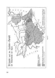
St. Lucia und die Luzien-Percht am Südostrande der Alpen
Österreich, Slowenien, Volkskunde Umschaden, Kurt ; Neunteufl, Walter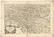
Partie du cercle d'Austriche, ou sont les duchés de Stirie, de Carinthie, de Carniole et autres estats heriditaires a la maison d'Austriche
1 : 630000 Korutansko (Rakousko) Sanson, Guillaume Jaillot, Alexis-Hubert H. Iaillot
Die Provinz Inner-OEsterreich oder die Herzogthümer Steyermark, Kaernten und Krain, die Grafschaften Goerz und Gradisca und das deutsch-oesterreichische Litorale
1 : 740000 Gorice a Gradiška Kindermann, Joseph Karl Junker, Christoph Franz Xaver Miller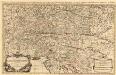
Partie du Cercle d'Austriche, ou sont Les Duchés de Stirie, de Carinthie, de Carniole
1 : 650000 Mollova mapová sbírka Sanson, Guillaume Jaillot, Alexis Hubert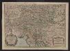
Partie du cercle d'Austriche ou sont les duchés de Stirie, de Carinthie, de Carniole et autres estats hereditaires a la maison d'Austriche
Kärnten, Steiermark Sanson, Guillaume ; Jaillot, Alexis Hubert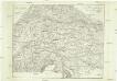
Post-Karte zur Geschichte des Kriegs von 1809
Itálie
Carte itinéraire pour servir a l'histoire de la guerre de 1809
Evropa střední
Karte von Inneroesterreich oder das Herzoghtum Steyermark, Kaernthen und Krain
1 : 1080000 Korutansko (Rakousko) T. Mollo
Circuli Austriaci in quo sunt archiducatus Austriae ducatus Stiriae Carintiae Carniolae comitatus Tirolis et episcopatus Tridentini novissima descriptio
1 : 920000 Evropa střední Danckerts, Justus per Iustinum Danckerts
Hertzogthumber Steyer, Karnten, Krain &c.
1 : 880000 Mollova mapová sbírka Sanson, Nicolas Sanson, Nicolas
Vogels Karte des Deutschen Reichs und der Alpenländer
1 : 500000 Augsburg-oblast (Německo) Vogel, Karl Langhans, Paul Justus Perthes
Übersichts Karte von Inner Österreich
1 : 575000 Korutansko (Rakousko) Schwab, G.
Vetvs Avstria Cisdanvbiana Norica
1 : 2160000 Mollova mapová sbírka Clüver, Philipp Fuhrmann, Mathias
Herzogthum Steyermark
Štýrsko (Rakousko)
Circuli Austriaci in quo Sunt Archiducatus Austriae Ducatus Stiriae Carintiae Carniolae et Episcopatus Tridentini Novissima Descriptio
1 : 900000 Mollova mapová sbírka Danckerts, Justus Danckerts, Justus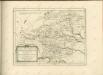

Karte der Kroländer Steyermark, Kärnthen, Krain und Istrien
1 : 1530000 Istrijský poloostrov (Slovinsko a Chorvatsko) Marco Berra
Wnitro-rakauské země
Chorvatsko
Blatt VI, uit: Geologische Übersichts-Karte der Österreichisch-Ungarischen Monarchie / nach den Aufnahmen der K.K. Geologischen Reichsanstalt bearb. von Franz Ritter von Hauer ; gezeichn. von Eduard Jahn
1 : 576000 Annotatie geografische gegevens: Gebaseerd op veldwerk in de jaren 1850 tot 1865 Hauer, Franz Ritter von; Jahn, Eduard; Kaiserlich-Königliche Geologische Reichsanstalt, Wenen Wien : Beck
Karte von Herzogthum Steyermark
1 : 860000 Štýrsko (Rakousko) Florian Mollo
Karnthen, Krain, Gorz-Gradisca, Istrien, Triest.
1 : 875000 Flemming, Carl
Die Provinz Inneroesterreich oder die Herzogthümer Steyermark, Kaernten und Krain, die Grafschaften Goerz und Gradisca und das deutsch-oesterreichische Litorale
1 : 730000 Gorice a Gradiška Kindermann, Joseph Karl Junker, Christoph Franz Xaver Miller
Carte du royaume d'Illirie et du duché de Styrie
1 : 520000 Ilýrie Raffelsperger, Franz Rumpold, F. au Dépôt des cartes typografiées
Karte von Inner-Österreich, das ist des Königreiches Illirien und des Herzogthumes Steiermark
1 : 880000 Ilýrie Raffelsperger, Franz Rumpold, F. im Typographischen Landkarten-Verlage
Karte von Herzogthum Steyermark
1 : 840000 Štýrsko (Rakousko) Tranquillo Mollo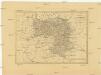
Charte von Herzogthum Steyermark
1 : 850000 Rakousko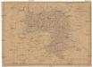
Charte vom Herzogthum Steyermark
1 : 870000 Štýrsko (Rakousko)
Charte vom Herzogthum Steyermark
1 : 870000 Štýrsko (Rakousko)
Slovinci ve Štýrsku, v Korutanech, v Kraňsku a v Přímoří
Jaderské moře (oblast) Brož, Josef Československá společnost zeměvědná