Maps of Timiș

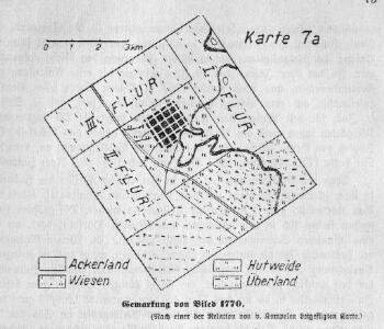
Gemarkung von Biled 1770
Biled
Gemarkung v. Biled 1912
Biled
Lambert-Cholesky sheet 1660 (Hodoni)
1 : 20000 Romanian military topographic map sheet under Lambert-Cholensky projection Direcția Topografică Militară geo-spatial.org Direcția Topografică Militară
Temesvár
1 : 75000 Timişoara
Lambert-Cholesky sheet 1560 (Şandra)
1 : 20000 Romanian military topographic map sheet under Lambert-Cholensky projection Institutul Geografic Militar geo-spatial.org Institutul Geografic Militar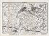
Lambert-Cholesky sheet 1659 (Becicherecul Mic)
1 : 20000 Romanian military topographic map sheet under Lambert-Cholensky projection Direcția Topografică Militară geo-spatial.org Direcția Topografică Militară
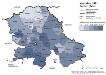
Die Nationalitätenverhältnisse der Banater Schwäbischen Heide nach der Volkszählung 1930/31
Banat ethnische Gruppe
Temesvar und Sandorhaza.
from Spezialkarte der osterreichisch-ungarischen Monarchie.
Plan der Angriffsarbeiten gegen die Festung Temesvár im Jahre 1849
1 : 14000 Temešvár (Rumunsko)
Das heutige Landschafts- und Siedlungsbild der Banater Schwäbischen Heide
Banat
Die Lage der Heide im natürlichen Landschaftsraum
Banat Landschaftsgliederung
Die hydrographischen Verhältnisse der Heide
Banat Hydrologie
Höhenkarte
Banat Gelände
Die Banater Schwäbische Heide zur Ansiedlungszeit nach den Originalkarten des Temeswarer Banats, aufgenommen 1769-1772 Kriegsarchiv Wien
Banat
Tekintetes Temes vármegye térképe
Temešvár (Rumunsko) Györy, Lajos Beichel, J.
C. Temesiensis
Rumänien Komitat Temesvár
C. Torontal
Ungarn Serbien Komitat Torontal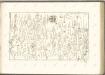

Das Oesterreichische-Kaiserthum

Plan von Bergwerg Laposneck
Mollova mapová sbírka Geyer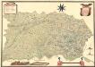
Mappa Der Grenz Scheidung Des Banat Temeswar Von Anno 1749 Mit Den Türken Geschlosen Von Herren General Feldmarschaů Lieutinont Freiheren Frantz Von Engelshofen A. 1749
Mollova mapová sbírka Geyer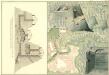
Plan des Bergwergs zu Lupkovo
Mollova mapová sbírka Geyer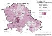
Vojvodina 1981. Jugoslawen (Jugosloveni)
Wojwodina ethnische Gruppe, Jugoslawen Hofinger, Veronika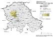
Vojvodina 1981. Montenegriner (Crnogorci)
Wojwodina ethnische Gruppe, Montenegriner Hofinger, Veronika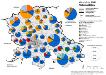
Vojvodina 1981. Nationalitäten
Wojwodina ethnische Gruppe Hofinger, Veronika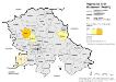
Vojvodina 1981. Ruthenen (Rusini)
Wojwodina ethnische Gruppe, Russinen Hofinger, Veronika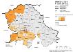
Vojvodina 1981. Kroaten (Hrvati)
Wojwodina ethnische Gruppe, Kroaten Hofinger, Veronika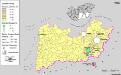
Siedlungsgebiet der Slowaken nach dem Nachbarschaftsindex für die Südliche Tiefebene 1880
Ungarn (Süd) Slowaken, Siedlung Bottlik, Zsolt