Maps of Sibenik

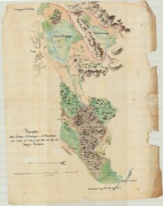
Topografia delle Paludi d'Ostrovizza e di Morpolazza
Prokljan-See, Mitteldalmatien, Relief
Zaravecchia und Stretto.
from Spezialkarte der osterreichisch-ungarischen Monarchie.
Zone 30, Col. XIII, Zaravecchia und Stretto, uit: Geologische Karte der im Reichsrathe vertretenen Königreiche und Länder der Österreich-Ungarischen Monarchie : auf Grundlage der Specialkarte i.M. 1:75.000 des k.u.k. Militär-geographischen Institutes / neu bearb. und als Kartenwerk von 341 Blattnummern in zwanglosen Lfg. hrsg. durch die k.k. Geologische Reichsanstalt in Wien
1 : 75000 titelvariant: Geologische Spezialkarte der im Reichsrate vertretenen Königreiche und Länder der Österreichisch-Ungarischen Monarchie; Geologische Specialkarte der im Reichsrathe vertretenen Königreiche und Länder der Österreichisch-Ungarischen Monarchie; Annotatie: Titel bovenaan kaartblad: Geologische Spezialkarte der im Reichsrate vertretenen Königreiche und Länder der Österreichisch-Ungarischen Monarchie en Geologische Specialkarte der im Reichsrathe vertretenen Königreiche und Länder der Österreichisch-Ungarischen Monarchie; Annotatie geografische gegevens: Coördinaten gebaseerd op nulmeridiaan van Ferro (Hierro) Kaiserlich-Königliche Geologische Reichsanstalt, Wenen Wien : K.K. Geologische Reichsanstalt
[Umgebung von Zadar]
Kroatien Dalmatien Zadar Umland
Sebenico und die Krkaseen
1 : 600000 Kroatien Krka-Gebiet Šibenik
Zarae, Et Sebenici Descriptio
Mollova mapová sbírka Lazius, Wolfgang
Die adriatische Küste von Zara bis Spalato
1 : 900000 Kroatien Adriaküste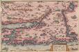
Zarae, Et Sebenici Descriptio [Karte], in: Theatrum orbis terrarum, S. 262.
1 Karte aus Atlas Ortelius, Abraham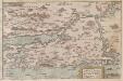
Zarae, et Sebenici Descriptio
Zadar (Region) Lazius, Wolfgang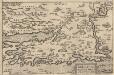
Zarae, Et Sebenici Descriptio [Karte], in: Theatrum orbis terrarum, S. 357.
1 Karte aus Atlas Ortelius, Abraham Vrients, Jan Baptista
Generalkarte von Zentraleuropa

[Generalkarte von Bosnien und der Hercegovina]
1 : 300000 Bosnien-Herzegowina Herzegowina
Adriatisches Meer, Küstenkarte
1 : 180000 Dugi Otok (Chorvatsko : ostrov) Oesterreicher, Tobias von Hydrographisches Amt der k. u. k. Kriegsmarine
Střední Dalmacie
1 : 750000 Dalmácie střední (Chorvatsko) Machát, František c. a k. voj. zeměpisný ústav
Westlicher Theil von Dalmatien
1 : 450000 Chorvatsko Santini, P. Engelman, J. W. F. A. Schraembl
Westlicher Theil von Dalmatien
1 : 445000 Chorvatsko Santini, P. Engelman, J. W. F. A. Schraembl
Iadera, Sicum et Aenona Vulgo Zara, Sibenico et Nona cum Insulis adiacentibus. in Parte Dalmatiae Boreali. [Karte], in: Het vijfde Deel Des Grooten Atlas : Vervatende De Water-Weereld, S. 234.
1 Karte aus Atlas Jansson, Jan Jansson, Jan
Iadera, Sicum et Aenona Vulgo Zara, Sibenico et Nona cum Insulis adjacentibus. in Parte Dalmatiae Boreali. [Karte], in: Novus atlas absolutissimus, Bd. 9, S. 314.
1 Karte aus Atlas Janssonius Offizin
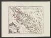
Charte des nordwestlichen Theiles von Dalmatien
Dalmácie (Chorvatsko) im Verlage des Kunst und Industrie Comptoirs
Charte des nordwestlichen Theil von Dalmatien
Dalmácie (Chorvatsko) Verlage der Kunst und Industrie
Partie de la Dalmatie du nord ouest
Dalmácie (Chorvatsko) im Verlage des Kunst und Industrie Comptoirs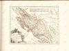
Der Noerdliche Theil Des Königreichs Dalmatien
1 : 1000000 Dalmatien

Jonction de la mer Adriatique á la Culpa
1 : 150000 Jaderské moře-oblast
Vermehrte und Verbesserte Landkarten des Königreichs Ungarn :
1 : 500000 Mollova mapová sbírka Stier, Martin Böner, Johann-Alexander Endter, Martin
Dalmatien und seine Hinterländer
1 : 1700000 Kroatien Dalmatien Bosnien Herzegowina
Zagreb, Brod, Osijek, Glina, Knin, Sarajevo
1 : 750000 Glina (Chorvatsko) Cronenberg, E. K. u. k. Militärgeographisches Institut
Agram, Brod, Esseg, Glina, Knin, Sarajevo
1 : 750000 Glina (Chorvatsko) K. u. k. Militärgeographisches Institut