Maps of Brasov

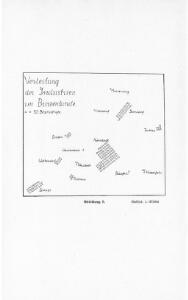
Verteilung der Industrien im Burzenlande
1 : 375000 Burzenland Produzierendes Gewerbe
Die deutschen und madjarischen Fluren des Burzenlandes
1 : 800000 Burzenland
Übersichtskarte vom Gebiet der Sektion "Kronstadt" des Siebenbürgischen Karpatenvereines
1 : 150000 Brašov (Rumunsko : oblast) Myszisch S. K. V.
Brasso [Kronstadt].
from Spezialkarte der osterreichisch-ungarischen Monarchie.
Brassó (Kronstadt)
1 : 75000 Brașov Geripp: J. Schwarz u. Offiz. J. Stumpf. Terrain: Rittm. E. Freih. v. Vecsey u. C. A. Scotti
Maršrut ot mon. Predjala do g. Kronštadta
1 : 42300 Brašov (Rumunsko) Beketov, V.
Hattertkarte von Honigberg
Rumänien Siebenbürgen Hărman
Lambert-Cholesky sheet 4057 (Est-Braşov)
1 : 20000 Romanian military topographic map sheet under Lambert-Cholensky projection Serviciul Geografic al Armatei geo-spatial.org Serviciul Geografic al Armatei
Lambert-Cholesky sheet 4056 (Satulunug)
1 : 20000 Romanian military topographic map sheet under Lambert-Cholensky projection Institutul Geografic Militar geo-spatial.org Institutul Geografic Militar
Lambert-Cholesky sheet 3958 (Hălchiu)
1 : 20000 Romanian military topographic map sheet under Lambert-Cholensky projection Serviciul Geografic al Armatei geo-spatial.org Serviciul Geografic al Armatei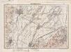
Lambert-Cholesky sheet 3957 (Vest Orașul Stalin)
1 : 20000 Romanian military topographic map sheet under Lambert-Cholensky projection Direcția Topografică Militară geo-spatial.org Direcția Topografică Militară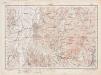
Lambert-Cholesky sheet 3956 (Rîșnov)
1 : 20000 Romanian military topographic map sheet under Lambert-Cholensky projection Direcția Topografică Militară geo-spatial.org Direcția Topografică Militară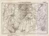
Lambert-Cholesky sheet 4058 (Preşmer)
1 : 20000 Romanian military topographic map sheet under Lambert-Cholensky projection Serviciul Geografic al Armatei geo-spatial.org Serviciul Geografic al Armatei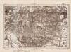
Lambert-Cholesky sheet 4059 (Sft. Gheorghe)
1 : 20000 Romanian military topographic map sheet under Lambert-Cholensky projection Direcția Topografică Militară geo-spatial.org Direcția Topografică Militară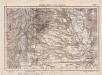
Lambert-Cholesky sheet 3959 (Feldioara)
1 : 20000 Romanian military topographic map sheet under Lambert-Cholensky projection Serviciul Geografic al Armatei geo-spatial.org Serviciul Geografic al Armatei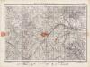
Lambert-Cholesky sheet 3858 (Vlădeni)
1 : 20000 Romanian military topographic map sheet under Lambert-Cholensky projection Direcția Topografică Militară geo-spatial.org Direcția Topografică Militară
Volksverteilung in Kronstadt
1 : 50000 Kronstadt (Siebenbürgen) ethnische Gruppe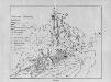
Kronstadt : Bebauung
1 : 20000 Kronstadt (Siebenbürgen)
Die Bierdörfer
1 : 50000 Săcele (Kreis Kronstadt, Siebenbürgen)
Rosenau
Rosenau (Rumänien) ethnische Gruppe
Petersberg
Sânpetru (Braşov) ethnische Gruppe
Honigberg
1 : 50000 Hărman
Tartlau
1 : 50000 Prejmer
Zeiden
1 : 50000 Codlea
Alt-Tohan
1 : 50000 Apaţa
Neudorf
1 : 50000 Burzenland
Kirchenburg in Wolkendorf
1 : 700 Vulcan Kirchenburg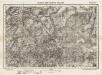
Lambert-Cholesky sheet 3857 (Şinca Noua)
1 : 20000 Romanian military topographic map sheet under Lambert-Cholensky projection Serviciul Geografic al Armatei geo-spatial.org Serviciul Geografic al Armatei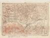
Lambert-Cholesky sheet 3856 (Zărneşti)
1 : 20000 Romanian military topographic map sheet under Lambert-Cholensky projection Direcția Topografică Militară geo-spatial.org Direcția Topografică Militară