Maps of Slovenia

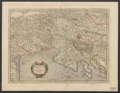
Karstia, Carniola et Windorum Marchia cum confinys. Per Gerardum Mercatorem cum privilegio
1 : 750000 Krain, Istrien Mercator, Gerhard, der Jüngere
Forum Iulium, Karstia, Carniola, Histria et Windorum Marchia
1 : 750000 Krain, Windische Mark Mercator, Gerhard, der Jüngere ; Hondius, Hendrik

Karstia, Carniola, Histria et Windorum Marchia. [Karte], in: Novus atlas absolutissimus, Bd. 2, S. 299.
1 Karte aus Atlas Janssonius Offizin
Karstia, Carniola, Histria et Windorum Marchia. [Karte], in: Theatrum orbis terrarum, sive, Atlas novus, Bd. 1, S. 117.
1 Karte aus Atlas Blaeu, Joan Blaeu, Willem Janszoon
Strassen-Karte des Königreiches Illyrien
1 : 424200 Ilýrie
Karstia, Carniola, Histria et Windorum Marchia. [Karte], in: Novus Atlas, das ist, Weltbeschreibung, Bd. 1, S. 204.
1 Karte aus Atlas Blaeu, Joan Blaeu, Willem Janszoon
Forum Iulium, Karstia, Carniola, Histria Et Windorum Marchia. [Karte], in: Gerardi Mercatoris Atlas, sive, Cosmographicae meditationes de fabrica mundi et fabricati figura, S. 450.
1 Karte aus Atlas Mercator, Gerhard Montanus, Petrus
Karstia, Carniola, Histria et Windorum Marchia. [Karte], in: Le théâtre du monde, ou, Nouvel atlas contenant les chartes et descriptions de tous les païs de la terre, Bd. 1, S. 233.
1 Karte aus Atlas Blaeu, Willem Janszoon und Blaeu, Joan Blaeu, Willem Janszoon

Karstia, Carniola, Histria et Windorum Marchia
Krain, Friaul Mercator, Gerhard, der Jüngere ; Blaeu, Willem Janszoon

KARSTIA, | CARNIOLA,| HISTRIA | et | WINDORVM | MARCHIA
Ger. Mercatore | Auctore. Guiljelm. Blaeu | excudit
Tabula Ducatus Carnioliae Vindorum Marchiae et Histriae ex mente Illustr. mi quondam
1 : 250000 Mollova mapová sbírka Homann, Johann Baptist
Strassen-Karte des Königreiches Illyrien
1 : 432000 Ilýrie

Königreich Illyrien
Grosser Hand-Atlas über alle Theile der Erde in 170 Karten Meyer, J. Verlag des Bibliographischen Instituts
General-Karte des Königreichs Jllyrien
1 : 295000 Ilýrie im k.k. Militaerischen geographischen Institute
F.7. Triest, uit: [Übersichtskarte von Europa 1:750.000]
1 : 750000 Wien : K.u.K. Militärgeographisches Institut
Die Kronländer Kärnthen, Krain, Görz und Gradisca, Istrien und die reichsunmittelbare Stadt Triest nach ihrer neuesten gerichtlichen & politischen Eintheilung
Gorice a Gradiška Bermann, Joseph Joseph Bermann
XII, uit: General-Karte des oesterreichischen Kaiserstaates mit einem grossen Theile der angrenzenden Länder / durch Josef Scheda ... bearb. und hrsg
1 : 576000 Annotatie geografische gegevens: Maatstokken: oesterreichische Meilen, geografische oder deutsche Meilen, preussische Meilen, türkische Berri, französische Lieues, russische Werste; Maatstok per blad: wiener Klafter, öster. Meilen; Blad XIX: statistische en taalkundige informatie; Blad XIX: legenda [Wien : K.K. Militärisch-Geografisches Institut]
Sheet XII: Karte Des Oesterreichischen Kaiserstaates.
1 : 576000 Scheda, Josef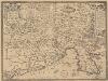
Fori Iulii Accurata Descriptio. [Karte], in: Theatrum orbis terrarum, S. 287.
1 Karte aus Atlas Ortelius, Abraham Vrients, Jan Baptista
Zemljovid slovenske dežele in pokrajin
Slowenien Knorr, A.
Partie méridionale du cercle d'Autriche qui comprend la basse partie du duché de Stirie, le duche de Carinthie, divisé en haute et basse, le duché de Carniole, divisé en haute, basse, moyenne et inter.e Carniole, et l'Istrie impériale
Kärnten, Steiermark Robert de Vaugondy, Didier
Fori Iulii Accurata Descriptio. [Karte], in: Theatrum orbis terrarum, S. 192.
1 Karte aus Atlas Ortelius, Abraham
Goritiae, Karstii, Chaczeolae, Carniolae, Histriae, Et Windorum Marchae Descrip. [Karte], in: Theatrum orbis terrarum, S. 186.
1 Karte aus Atlas Ortelius, Abraham
Illyrien.
1 : 880000 Radefeld, Carl Christian Franz, 1788-1874
Ducatus Carintiae et Carnioliae Cilleiaeque Comitatus
1 : 600000 Mollova mapová sbírka Wit, Frederik de Mortier, Pierre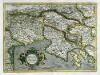
Forvm Ivlivm, Karstia, Carniola, Histria et Windorvm Marchia
1 Karte : Kupferdruck ; 33 x 45 cm Mercator; Hondius Henricus Hondius
Forvm Ivlivm, Karstia, Carniola, Histria et Windorvm Marchia
1 Karte : Kupferdruck ; 33 x 45 cm Mercator s.n.