Maps of Slovenia

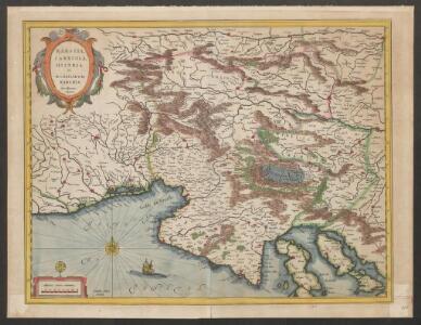
Karstia, Carniola, Histria et Windorum Marchia
Krain, Friaul Mercator, Gerhard, der Jüngere ; Blaeu, Willem Janszoon
KARSTIA, | CARNIOLA,| HISTRIA | et | WINDORVM | MARCHIA
Ger. Mercatore | Auctore. Guiljelm. Blaeu | excudit
Karstia, Carniola, Histria et Windorum Marchia. [Karte], in: Le théâtre du monde, ou, Nouvel atlas contenant les chartes et descriptions de tous les païs de la terre, Bd. 1, S. 233.
1 Karte aus Atlas Blaeu, Willem Janszoon und Blaeu, Joan Blaeu, Willem Janszoon
Karstia, Carniola, Histria et Windorum Marchia. [Karte], in: Novus Atlas, das ist, Weltbeschreibung, Bd. 1, S. 204.
1 Karte aus Atlas Blaeu, Joan Blaeu, Willem Janszoon
Karstia, Carniola, Histria et Windorum Marchia. [Karte], in: Theatrum orbis terrarum, sive, Atlas novus, Bd. 1, S. 117.
1 Karte aus Atlas Blaeu, Joan Blaeu, Willem Janszoon
Karstia, Carniola, Histria et Windorum Marchia. [Karte], in: Novus atlas absolutissimus, Bd. 2, S. 299.
1 Karte aus Atlas Janssonius Offizin


Forum Iulium, Karstia, Carniola, Histria et Windorum Marchia
1 : 750000 Krain, Windische Mark Mercator, Gerhard, der Jüngere ; Hondius, Hendrik
Karstia, Carniola et Windorum Marchia cum confinys. Per Gerardum Mercatorem cum privilegio
1 : 750000 Krain, Istrien Mercator, Gerhard, der Jüngere
Strassen-Karte des Königreiches Illyrien
1 : 424200 Ilýrie
Forum Iulium, Karstia, Carniola, Histria Et Windorum Marchia. [Karte], in: Gerardi Mercatoris Atlas, sive, Cosmographicae meditationes de fabrica mundi et fabricati figura, S. 450.
1 Karte aus Atlas Mercator, Gerhard Montanus, Petrus
Strassen-Karte des Königreiches Illyrien
1 : 432000 Ilýrie
Tabula Ducatus Carnioliae Vindorum Marchiae et Histriae ex mente Illustr. mi quondam
1 : 250000 Mollova mapová sbírka Homann, Johann Baptist
Partie méridionale du cercle d'Autriche qui comprend la basse partie du duché de Stirie, le duche de Carinthie, divisé en haute et basse, le duché de Carniole, divisé en haute, basse, moyenne et inter.e Carniole, et l'Istrie impériale
Kärnten, Steiermark Robert de Vaugondy, Didier

Goritiae, Karstii, Chaczeolae, Carniolae, Histriae, Et Windorum Marchae Descrip. [Karte], in: Theatrum orbis terrarum, S. 186.
1 Karte aus Atlas Ortelius, Abraham
Die Kronländer Kärnthen, Krain, Görz und Gradisca, Istrien und die reichsunmittelbare Stadt Triest nach ihrer neuesten gerichtlichen & politischen Eintheilung
Gorice a Gradiška Bermann, Joseph Joseph Bermann
Königreich Illyrien
Grosser Hand-Atlas über alle Theile der Erde in 170 Karten Meyer, J. Verlag des Bibliographischen Instituts
General-Karte des Königreichs Jllyrien
1 : 295000 Ilýrie im k.k. Militaerischen geographischen Institute
Karstia Carniola Histria et Windorvm Marchia
1 : 850000 Mollova mapová sbírka Merian, Matthaeus Merian, Caspar - dědici
Zemljovid slovenske dežele in pokrajin
Slowenien Knorr, A.
Descriptio Totius Lyridis XVI. No. Tab. [Karte], in: Claud. Ptolemaeus. Geographia lat. cum mappis [...], S. 404.
1 Karte aus Atlas Münster, Sebastian [und Ptolemaeus, Claudius]
Goritiae, Karstii, Chaczeolae, Carniolae, Histriae, Et Windorum Marchae Descrip. [Karte], in: Theatrum orbis terrarum, S. 281.
1 Karte aus Atlas Ortelius, Abraham Vrients, Jan Baptista
Autriche meridionale.
1 : 480000 Robert de Vaugondy, Gilles, 1688-1766
Das Herzogth. Steiermark, das Herzogth. Kärnten, das Herzogth. Krain, das Küstenland (Triest, Görz-Gradisca, Istrien)
Štýrsko (Rakousko) Benecke Bormann, E. Ignaz Fuchs

General-Karte des Königreichs Yllyrien
1 : 295000 Ilýrie