Maps of Târgu Secuiesc

Kézdivásárhely
1 : 75000 Județ Covasna
Lambert-Cholesky sheet 4263 (Doboiu)
1 : 20000 Romanian military topographic map sheet under Lambert-Cholensky projection Serviciul Geografic al Armatei geo-spatial.org Serviciul Geografic al Armatei
Lambert-Cholesky sheet 4262 (Polian)
1 : 20000 Romanian military topographic map sheet under Lambert-Cholensky projection Serviciul Geografic al Armatei geo-spatial.org Serviciul Geografic al Armatei
Lambert-Cholesky sheet 4163 (Tuşnad)
1 : 20000 Romanian military topographic map sheet under Lambert-Cholensky projection Direcția Topografică Militară geo-spatial.org Direcția Topografică Militară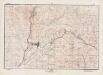
Lambert-Cholesky sheet 4162 (Bicsad)
1 : 20000 Romanian military topographic map sheet under Lambert-Cholensky projection Direcția Topografică Militară geo-spatial.org Direcția Topografică Militară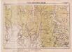
Lambert-Cholesky sheet 4362 (Esztelnek)
1 : 20000 Romanian military topographic map sheet under Lambert-Cholensky projection Serviciul Geografic al Armatei geo-spatial.org Serviciul Geografic al Armatei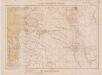
Lambert-Cholesky sheet 4261 (Kezdi-Osorhei)
1 : 20000 Romanian military topographic map sheet under Lambert-Cholensky projection Serviciul Geografic al Armatei geo-spatial.org Serviciul Geografic al Armatei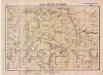
Lambert-Cholesky sheet 4363 (Muntele Şandor)
1 : 20000 Romanian military topographic map sheet under Lambert-Cholensky projection Serviciul Geografic al Armatei geo-spatial.org Serviciul Geografic al Armatei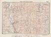
Lambert-Cholesky sheet 4161 (Malnaş)
1 : 20000 Romanian military topographic map sheet under Lambert-Cholensky projection Direcția Topografică Militară geo-spatial.org Direcția Topografică Militară
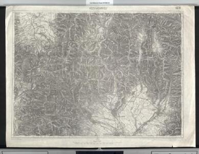
Kezdi-Vasarhely.
from Spezialkarte der osterreichisch-ungarischen Monarchie.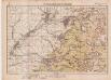
Lambert-Cholesky sheet 4361 (Breţcu)
1 : 20000 Romanian military topographic map sheet under Lambert-Cholensky projection Serviciul Geografic al Armatei geo-spatial.org Serviciul Geografic al Armatei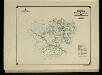
Harta Cailor de Comunicatie din Judetul Bacau
Rumänien Judeţ Bacău Verkehrsweg
Czik-Menasag.
from Spezialkarte der osterreichisch-ungarischen Monarchie.
Ojtoz Pasz.
from Spezialkarte der osterreichisch-ungarischen Monarchie.
Barot.
from Spezialkarte der osterreichisch-ungarischen Monarchie.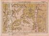
Lambert-Cholesky sheet 4264 (Părâul Uzului)
1 : 20000 Romanian military topographic map sheet under Lambert-Cholensky projection Serviciul Geografic al Armatei geo-spatial.org Serviciul Geografic al Armatei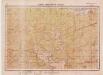
Lambert-Cholesky sheet 4364 (Poiana Uzului)
1 : 20000 Romanian military topographic map sheet under Lambert-Cholensky projection Serviciul Geografic al Armatei geo-spatial.org Serviciul Geografic al Armatei
Ost-Karpathen
1 : 600000 Karpaten (Südost)
Generalkarte von Zentraleuropa

[Střední Rumunsko]
1 : 420600 Rumunsko Schraembl, Franz Anton F.A. Schraembl
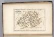
Siebenbürgen
Sedmihradsko (Rumunsko) Kunst- und Industrie Comptoir
Carte de la Roumanie et pays limitrophes. Klausenbourg
1 : 500000 France. Service géographique de l'armée [Paris] : Service géographique de l'armée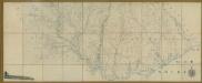
Carte de la Moldavie
1 : 330000 Moldawien, Bessarabien
Generalkarte Von Siebenbürgen. Nach geometrisch gemessenen Karten und andern zuverlaessigen Hilfsmitteln verjüngt, und graduirt von Herrn A. von Wenzely. Herausgegeben von Herrn F. A. Schraembl
1 : 430000 Siebenbürgen Produkt, Straßennetz Wenzely, Anton; Schraembl, Franz Anton
Sheet XV: Karte Des Oesterreichischen Kaiserstaates.
1 : 576000 Scheda, Josef
Übersichtskarte von Mittel - Europa
Switzerland.
1 : 1500000 Carey, Mathew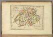
Switzerland.
1 : 1450000 Carey, Mathew
Switzerland.
1 : 1500000 Carey, Mathew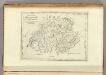
Switzerland.
1 : 500000 Carey, Mathew