Maps of Hunedoara

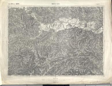
Maros-Illye
1 : 75000 Ilia (Hunedoara)
Lambert-Cholesky sheet 2460 (Dobra)
1 : 20000 Romanian military topographic map sheet under Lambert-Cholensky projection Institutul Geografic Militar geo-spatial.org Institutul Geografic Militar
Lambert-Cholesky sheet 2459 (Roşcani)
1 : 20000 Romanian military topographic map sheet under Lambert-Cholensky projection Direcția Topografică Militară geo-spatial.org Direcția Topografică Militară
Lambert-Cholesky sheet 2359 (Crivina de Sus)
1 : 20000 Romanian military topographic map sheet under Lambert-Cholensky projection Direcția Topografică Militară geo-spatial.org Direcția Topografică Militară
Lambert-Cholesky sheet 2360 (Coşteiu de Sus)
1 : 20000 Romanian military topographic map sheet under Lambert-Cholensky projection Direcția Topografică Militară geo-spatial.org Direcția Topografică Militară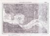
Lambert-Cholesky sheet 2560 (Branişca)
1 : 20000 Romanian military topographic map sheet under Lambert-Cholensky projection Serviciul Geografic al Armatei geo-spatial.org Serviciul Geografic al Armatei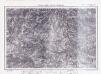
Lambert-Cholesky sheet 2559 (Almaşul Sec)
1 : 20000 Romanian military topographic map sheet under Lambert-Cholensky projection Direcția Topografică Militară geo-spatial.org Direcția Topografică Militară
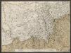
Maros-Illye.
from Spezialkarte der osterreichisch-ungarischen Monarchie.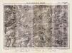
Lambert-Cholesky sheet 2458 (Runcul Mare)
1 : 20000 Romanian military topographic map sheet under Lambert-Cholensky projection Direcția Topografică Militară geo-spatial.org Direcția Topografică Militară
Lambert-Cholesky sheet 2358 (Vrf. Chicioara)
1 : 20000 Romanian military topographic map sheet under Lambert-Cholensky projection Institutul Geografic Militar geo-spatial.org Institutul Geografic Militar
Lambert-Cholesky sheet 2558 (Hunedoara)
1 : 20000 Romanian military topographic map sheet under Lambert-Cholensky projection Institutul Geografic Militar geo-spatial.org Institutul Geografic Militar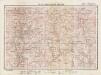
Lambert-Cholesky sheet 2461 (Cărmăzineşti)
1 : 20000 Romanian military topographic map sheet under Lambert-Cholensky projection Direcția Topografică Militară geo-spatial.org Direcția Topografică Militară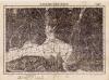
Lambert-Cholesky sheet 2361 (Petriş)
1 : 20000 Romanian military topographic map sheet under Lambert-Cholensky projection Institutul Geografic Militar geo-spatial.org Institutul Geografic Militar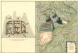
Plan des Bergwergs Rapold
Mollova mapová sbírka Geyer
Korosbanya.
from Spezialkarte der osterreichisch-ungarischen Monarchie.
Deva und Szaszvaros.
from Spezialkarte der osterreichisch-ungarischen Monarchie.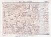
Lambert-Cholesky sheet 2561 (Furcşoara)
1 : 20000 Romanian military topographic map sheet under Lambert-Cholensky projection Institutul Geografic Militar geo-spatial.org Institutul Geografic Militar
Süd-Ost-Ungarn
1 : 600000 Österreich-Ungarn (Südost), Banat
Generalkarte von Zentraleuropa

Vermehrte und Verbesserte Landkarten des Königreichs Ungarn :
1 : 500000 Mollova mapová sbírka Stier, Martin Böner, Johann-Alexander Endter, Martin
Plan von Bergwerg Laposneck
Mollova mapová sbírka Geyer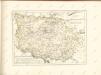

Tabula Bannatus Temesiensis a Geometris S.S.M.M.I.I. et R.A. confecta; quam in minorem formam reduxit, gradusque longitudinis, et latitudinis adjecit Franciscus Griselini. Augustinus Cipps sculpsit
1 : 480000 Temescher Banat Griselini, Francesco, http://d-nb.info/gnd/129735183; Cipps, Augustin, http://d-nb.info/gnd/130565644
Carte von Temescher Banat
1 : 220000 Banát Péchy von Péchyujfalu
Ober Ungern
Rumunsko Kipferling, Karl Joseph im Verlage des Kunst und Industrie Comptoir's
Ober Ungern
Rumunsko Kipferling, Karl Joseph im Verlage des Kunst und Industrie Comptoir's
Eigendliche Vorstellung des zwischen denen Key; und ein Corpo von 30000 Turken unter anführung des Seras Kiers von Widdin den 29. Jull. 1739 in dem Banat von Temeswar unweit Banzova glüklich vorbey gegangenen treffen nebst beygefugter Karten des aldortigen Terrain auf 14 Meilen
Mollova mapová sbírka
Temeschwarer Bannat
1 : 493000 Banát Benedicti, Hieronymus
Sheet XIV: Karte Des Oesterreichischen Kaiserstaates.
1 : 576000 Scheda, Josef