Maps of Kiszombor

Makó
1 : 75000 Makó (Csongrád)
Mako und Nagyszentmiklos.; Spezialkarte der osterreichisch-ungarischen Monarchie.
from Spezialkarte der osterreichisch-ungarischen Monarchie. Austro-Hungarian Monarchy. Militärgeographisches Institut.,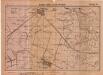
Lambert-Cholesky sheet 1363 (Zomborul Mic)
1 : 20000 Romanian military topographic map sheet under Lambert-Cholensky projection Serviciul Geografic al Armatei geo-spatial.org Serviciul Geografic al Armatei
Lambert-Cholesky sheet 1362 (Bessneyo)
1 : 20000 Romanian military topographic map sheet under Lambert-Cholensky projection Serviciul Geografic al Armatei geo-spatial.org Serviciul Geografic al Armatei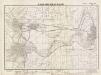
Lambert-Cholesky sheet 1463 (Nadlac Vest)
1 : 20000 Romanian military topographic map sheet under Lambert-Cholensky projection Direcția Topografică Militară geo-spatial.org Direcția Topografică Militară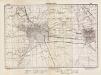
Lambert-Cholesky sheet 1462 (Sânnicolaul Mare)
1 : 20000 Romanian military topographic map sheet under Lambert-Cholensky projection Direcția Topografică Militară geo-spatial.org Direcția Topografică Militară
Die hydrographischen Verhältnisse der Heide
Banat Hydrologie
Höhenkarte
Banat Gelände
Die Lage der Heide im natürlichen Landschaftsraum
Banat Landschaftsgliederung
Lambert-Cholesky sheet 1464 (Csanad Palota)
1 : 20000 Romanian military topographic map sheet under Lambert-Cholensky projection Serviciul Geografic al Armatei geo-spatial.org Serviciul Geografic al Armatei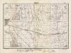
Lambert-Cholesky sheet 1563 (Nădlac Est)
1 : 20000 Romanian military topographic map sheet under Lambert-Cholensky projection Direcția Topografică Militară geo-spatial.org Direcția Topografică Militară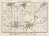
Lambert-Cholesky sheet 1562 (Periam)
1 : 20000 Romanian military topographic map sheet under Lambert-Cholensky projection Direcția Topografică Militară geo-spatial.org Direcția Topografică Militară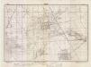
Lambert-Cholesky sheet 1461 (Tomnatec)
1 : 20000 Romanian military topographic map sheet under Lambert-Cholensky projection Direcția Topografică Militară geo-spatial.org Direcția Topografică Militară
Segedin
1 : 200000 Szeged (Maďarsko) Kartografska radionica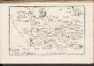
C. Csanád
Ungarn Csanád (Megye)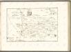

Die Banater Schwäbische Heide zur Ansiedlungszeit nach den Originalkarten des Temeswarer Banats, aufgenommen 1769-1772 Kriegsarchiv Wien
Banat
Das heutige Landschafts- und Siedlungsbild der Banater Schwäbischen Heide
Banat
Die Nationalitätenverhältnisse der Banater Schwäbischen Heide nach der Volkszählung 1930/31
Banat ethnische Gruppe
Nagykikinda.
from Spezialkarte der osterreichisch-ungarischen Monarchie.
Torokkanizsa.
from Spezialkarte der osterreichisch-ungarischen Monarchie.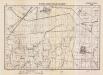
Lambert-Cholesky sheet 1564 (Nemet-Pereg)
1 : 20000 Romanian military topographic map sheet under Lambert-Cholensky projection Serviciul Geografic al Armatei geo-spatial.org Serviciul Geografic al Armatei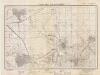
Lambert-Cholesky sheet 1361 (Teremia Mică)
1 : 20000 Romanian military topographic map sheet under Lambert-Cholensky projection Direcția Topografică Militară geo-spatial.org Direcția Topografică Militară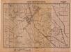
Lambert-Cholesky sheet 1262 (Oroszlamos)
1 : 20000 Romanian military topographic map sheet under Lambert-Cholensky projection Institutul Geografic al Armatei geo-spatial.org Institutul Geografic al Armatei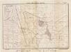
Lambert-Cholesky sheet 1263 (Beba Veche)
1 : 20000 Romanian military topographic map sheet under Lambert-Cholensky projection Direcția Topografică Militară geo-spatial.org Direcția Topografică Militară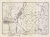
Lambert-Cholesky sheet 1561 (Pesac)
1 : 20000 Romanian military topographic map sheet under Lambert-Cholensky projection Direcția Topografică Militară geo-spatial.org Direcția Topografică Militară
C. Torontal
Ungarn Serbien Komitat Torontal

Generalkarte von Zentraleuropa