Maps of Újszentiván

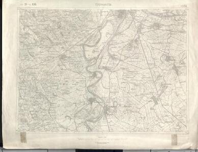
Törökkanizsa
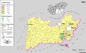
1 : 75000 Novi Kneževac, Wojwodina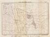
Lambert-Cholesky sheet 1263 (Beba Veche)
1 : 20000 Romanian military topographic map sheet under Lambert-Cholensky projection Direcția Topografică Militară geo-spatial.org Direcția Topografică Militară
Lambert-Cholesky sheet 1262 (Oroszlamos)
1 : 20000 Romanian military topographic map sheet under Lambert-Cholensky projection Institutul Geografic al Armatei geo-spatial.org Institutul Geografic al Armatei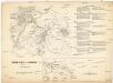
Schlacht von Szöreg am 5ten August 1849
1 : 60600 Szeged (Maďarsko)
Torokkanizsa.
from Spezialkarte der osterreichisch-ungarischen Monarchie.
Segedin
1 : 200000 Szeged (Maďarsko) Kartografska radionica
Bács-Bodrog vármegye térképe
1 : 450000 Kogutowicz, Manó Magyar Földrajzi Intézet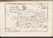
C. Csanád
Ungarn Csanád (Megye)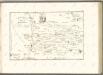

Kistelek und Szeged.
from Spezialkarte der osterreichisch-ungarischen Monarchie.
Lambert-Cholesky sheet 1261 (Cernabara)
1 : 20000 Romanian military topographic map sheet under Lambert-Cholensky projection Serviciul Geografic al Armatei geo-spatial.org Serviciul Geografic al Armatei
Generalkarte von Zentraleuropa

Siedlungsgebiet der Deutschen nach dem Nachbarschaftsindex für das Komitat Bács-Kiskun 1941
Bács-Kiskun Deutsche, Siedlung Bottlik, Zsolt
A horvátok aránya és száma Bács-Kiskun megyében 1941-ben
Bács-Kiskun Kroaten, Siedlung Bottlik, Zsolt
A horvátok aránya és száma Bács-Kiskun megyében 1980-ban
Bács-Kiskun Kroaten, Siedlung Bottlik, Zsolt
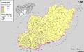
A németek településterülete a szomszédsági mutató alapján Bács-Kiskun megyében 1980-ban
Bács-Kiskun Deutsche, Siedlung Bottlik, Zsolt
A németek településterülete a szomszédsági mutató alapján Bács-Kiskun megyében 1880-ban
Bács-Kiskun Deutsche, Siedlung Bottlik, Zsolt
A németek településterülete a szomszédsági mutató alapján Bács-Kiskun megyében 1941-ban
Bács-Kiskun Deutsche, Siedlung Bottlik, Zsolt
C. Bacsiensis
Ungarn Komitat Bács-Bodrog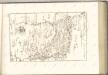
Serben in Süd-Transdanubien und im Komitat Bács-Kiskun 1880
Transdanubien (Süd), Bács-Kiskun, Serben, Siedlung Bottlik, Zsolt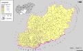
A szerbek aránya és száma a Dél-Dunántúlon és Bács-Kiskun megyében 1880-ban
Transdanubien (Süd), Bács-Kiskun, Serben, Siedlung Bottlik, Zsolt
Serben in Süd-Transdanubien und im Komitat Bács-Kiskun 1941
Transdanubien (Süd), Bács-Kiskun, Serben, Siedlung Bottlik, Zsolt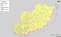
A szerbek aránya és száma a Dél-Dunántúlon és Bács-Kiskun megyében 1941-ben
Transdanubien (Süd), Bács-Kiskun, Serben, Siedlung Bottlik, Zsolt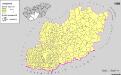
A szerbek aránya és száma a Dél-Dunántúlon és Bács-Kiskun megyében 1980-ban
Transdanubien (Süd), Bács-Kiskun, Serben, Siedlung Bottlik, Zsolt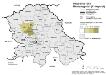
Vojvodina 1981. Montenegriner (Crnogorci)
Wojwodina ethnische Gruppe, Montenegriner Hofinger, Veronika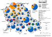
Vojvodina 1981. Nationalitäten
Wojwodina ethnische Gruppe Hofinger, Veronika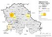
Vojvodina 1981. Ruthenen (Rusini)
Wojwodina ethnische Gruppe, Russinen Hofinger, Veronika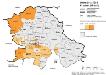
Vojvodina 1981. Kroaten (Hrvati)
Wojwodina ethnische Gruppe, Kroaten Hofinger, Veronika