Maps of Cluj

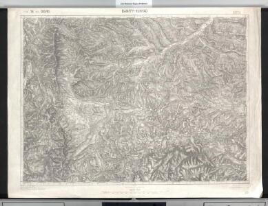
Bánffy-Hunyad
1 : 75000 Huedin, Judeţ Klausenburg
Lambert-Cholesky sheet 2671 (Fildul de Mijloc)
1 : 20000 Romanian military topographic map sheet under Lambert-Cholensky projection Serviciul Geografic al Armatei geo-spatial.org Serviciul Geografic al Armatei
Lambert-Cholesky sheet 2670 (Huedin)
1 : 20000 Romanian military topographic map sheet under Lambert-Cholensky projection Serviciul Geografic al Armatei geo-spatial.org Serviciul Geografic al Armatei
Lambert-Cholesky sheet 2771 (Almașul Mare)
1 : 20000 Romanian military topographic map sheet under Lambert-Cholensky projection Serviciul Geografic al Armatei geo-spatial.org Serviciul Geografic al Armatei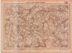
Lambert-Cholesky sheet 2770 (Aghireş)
1 : 20000 Romanian military topographic map sheet under Lambert-Cholensky projection Serviciul Geografic al Armatei geo-spatial.org Serviciul Geografic al Armatei
Banffy-Hunyad (Ungarn).
from Spezialkarte der osterreichisch-ungarischen Monarchie.
Lambert-Cholesky sheet 2769 (Mănășturul Unguresc)
1 : 20000 Romanian military topographic map sheet under Lambert-Cholensky projection Serviciul Geografic al Armatei geo-spatial.org Serviciul Geografic al Armatei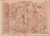
Lambert-Cholesky sheet 2669 (Mărgău)
1 : 20000 Romanian military topographic map sheet under Lambert-Cholensky projection Serviciul Geografic al Armatei geo-spatial.org Serviciul Geografic al Armatei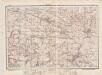
Lambert-Cholesky sheet 2871 (Cubleşul)
1 : 20000 Romanian military topographic map sheet under Lambert-Cholensky projection Direcția Topografică Militară geo-spatial.org Direcția Topografică Militară
Lambert-Cholesky sheet 2672 (Bucium)
1 : 20000 Romanian military topographic map sheet under Lambert-Cholensky projection Serviciul Geografic al Armatei geo-spatial.org Serviciul Geografic al Armatei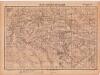
Lambert-Cholesky sheet 2772 (Sânta Maria)
1 : 20000 Romanian military topographic map sheet under Lambert-Cholensky projection Serviciul Geografic al Armatei geo-spatial.org Serviciul Geografic al Armatei
Magura.
from Spezialkarte der osterreichisch-ungarischen Monarchie.
Kolozsvar [Klausenburg].
from Spezialkarte der osterreichisch-ungarischen Monarchie.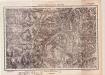
Lambert-Cholesky sheet 2570 (Lunca)
1 : 20000 Romanian military topographic map sheet under Lambert-Cholensky projection Institutul Geografic al Armatei geo-spatial.org Institutul Geografic al Armatei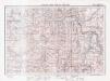
Lambert-Cholesky sheet 2571 (Valea Drăganului)
1 : 20000 Romanian military topographic map sheet under Lambert-Cholensky projection Direcția Topografică Militară geo-spatial.org Direcția Topografică Militară
Lambert-Cholesky sheet 2869 (Gilău)
1 : 20000 Romanian military topographic map sheet under Lambert-Cholensky projection Direcția Topografică Militară geo-spatial.org Direcția Topografică Militară
Lambert-Cholesky sheet 2872 (Drag)
1 : 20000 Romanian military topographic map sheet under Lambert-Cholensky projection Serviciul Geografic al Armatei geo-spatial.org Serviciul Geografic al Armatei
Lambert-Cholesky sheet 2569 (Vrf. Vlădeasa)
1 : 20000 Romanian military topographic map sheet under Lambert-Cholensky projection Serviciul Geografic al Armatei geo-spatial.org Serviciul Geografic al Armatei
Lambert-Cholesky sheet 2572 (Tusa)
1 : 20000 Romanian military topographic map sheet under Lambert-Cholensky projection Institutul Geografic Militar geo-spatial.org Institutul Geografic Militar
Vermehrte und Verbesserte Landkarten des Königreichs Ungarn :
1 : 500000 Mollova mapová sbírka Stier, Martin Böner, Johann-Alexander Endter, Martin
Siebenbürgen
Sedmihradsko (Rumunsko) Kipferling, Karl Joseph im Verlage des Kunst und Industrie Comptoir's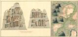
Plan dern Bergwerg bei Carlburg und Vardia
Mollova mapová sbírka Geyer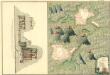
Plan von Bergwerg Pestian und Ivota
Mollova mapová sbírka Geyer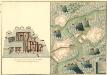
Plan der Bergwerg, Flod, Gilamare und Giogy
Mollova mapová sbírka Geyer
Siebenbürgen
Sedmihradsko (Rumunsko) Kunst- und Industrie Comptoir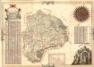
Mapa Particvlaris Transilvaniae
Mollova mapová sbírka Geyer
Transylvaniae Principatus
1 : 720000 Mollova mapová sbírka Seutter, Matthäus Seutter, Matthäus
Nova Transilvaniae Principatus Tabula. Novissima descriptia editia
1 : 730000 Mollova mapová sbírka Ottens, Reinier Ottens, Josua
Principatus Transilvaniae
1 : 720000 Mollova mapová sbírka Homann, Johann Baptist Homann, Johann Baptista