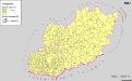
Maps of Tiszakécskei járás

Tisza-Inoka
1 : 75000 Komitat Jász-Nagykun-Szolnok
Tisza-Inoka.
from Spezialkarte der osterreichisch-ungarischen Monarchie.
Kecskemét 163, uit: Special-Karte von Mittel-Europa / nach amtlichen Quellen bearbeitet von W. Liebenow
1 : 300000 titelvariant: W. Liebenow's Mittel-Europa; Annotatie: Titel boven de bladen: W. Liebenow's Mittel-Europa Johannes Wilhelm Liebenow 1822-1897 Frankfurt a. M. : Ludwig Ravenstein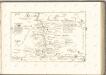

Jász-Nagykun-Szolnok vármegye térképe
1 : 500000 Szolnok (Maďarsko : oblast) Kogutowicz, Manó Magyar Földrajzi Intézet
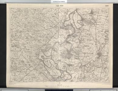
Szolnok.
from Spezialkarte der osterreichisch-ungarischen Monarchie.
Kiskunfelegyhaza und Szegvar.
from Spezialkarte der osterreichisch-ungarischen Monarchie.
Szarvas.
from Spezialkarte der osterreichisch-ungarischen Monarchie.

Serben in der Südlichen Tiefebene 1980
Großes Ungarisches Tiefland (Süd) Serben, Siedlung Bottlik, Zsolt
C. Heves und Szólnok
Ungarn Komitat Heves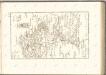

Siedlungsgebiet der Deutschen nach dem Nachbarschaftsindex für das Komitat Bács-Kiskun 1941
Bács-Kiskun Deutsche, Siedlung Bottlik, Zsolt
Serben in der Südlichen Tiefebene 1941
Großes Ungarisches Tiefland (Süd) Serben, Siedlung Bottlik, Zsolt
C. Pestensis
Ungarn Komitat Pest
Generalkarte von Zentraleuropa

A horvátok aránya és száma Bács-Kiskun megyében 1941-ben
Bács-Kiskun Kroaten, Siedlung Bottlik, Zsolt
A szerbek aránya és száma a Dél-Alföldön 1880-ban
Großes Ungarisches Tiefland (Süd) Serben, Siedlung Bottlik, Zsolt
A horvátok aránya és száma Bács-Kiskun megyében 1980-ban
Bács-Kiskun Kroaten, Siedlung Bottlik, Zsolt
Serben in der Südlichen Tiefebene 1880
Großes Ungarisches Tiefland (Süd) Serben, Siedlung Bottlik, Zsolt
A németek településterülete a szomszédsági mutató alapján Bács-Kiskun megyében 1980-ban
Bács-Kiskun Deutsche, Siedlung Bottlik, Zsolt
A szerbek aránya és száma a Dél-Alföldön 1941-ben
Großes Ungarisches Tiefland (Süd) Serben, Siedlung Bottlik, Zsolt
A szerbek aránya és száma a Dél-Alföldön 1980-ban
Großes Ungarisches Tiefland (Süd) Serben, Siedlung Bottlik, Zsolt
A németek településterülete a szomszédsági mutató alapján Bács-Kiskun megyében 1880-ban
Bács-Kiskun Deutsche, Siedlung Bottlik, Zsolt
A németek településterülete a szomszédsági mutató alapján Bács-Kiskun megyében 1941-ban
Bács-Kiskun Deutsche, Siedlung Bottlik, Zsolt
Pesth-Solter, Csongráder, Szolnoker Comitat und das Ober Capitanat von Jazygien und Cumanien
1 : 280000 Budapešť-oblast (Maďarsko)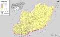
Serben in Süd-Transdanubien und im Komitat Bács-Kiskun 1880
Transdanubien (Süd), Bács-Kiskun, Serben, Siedlung Bottlik, Zsolt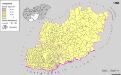
A szerbek aránya és száma a Dél-Dunántúlon és Bács-Kiskun megyében 1880-ban
Transdanubien (Süd), Bács-Kiskun, Serben, Siedlung Bottlik, Zsolt
Serben in Süd-Transdanubien und im Komitat Bács-Kiskun 1941
Transdanubien (Süd), Bács-Kiskun, Serben, Siedlung Bottlik, Zsolt