Maps of Bihor
Szilágy-Somlyó
1 : 75000 Şimleul-Silvaniei, Umland
Lambert-Cholesky sheet 2474 (Ip)
1 : 20000 Romanian military topographic map sheet under Lambert-Cholensky projection Institutul Geografic Militar geo-spatial.org Institutul Geografic Militar
Lambert-Cholesky sheet 2473 (Valea Ungurului)
1 : 20000 Romanian military topographic map sheet under Lambert-Cholensky projection Institutul Geografic Militar geo-spatial.org Institutul Geografic Militar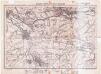
Lambert-Cholesky sheet 2574 (Șimleul Silvaniei)
1 : 20000 Romanian military topographic map sheet under Lambert-Cholensky projection Direcția Topografică Militară geo-spatial.org Direcția Topografică Militară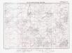
Lambert-Cholesky sheet 2573 (Vălcăul de Jos)
1 : 20000 Romanian military topographic map sheet under Lambert-Cholensky projection Institutul Geografic Militar geo-spatial.org Institutul Geografic Militar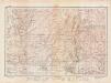
Lambert-Cholesky sheet 2373 (Aleşd)
1 : 20000 Romanian military topographic map sheet under Lambert-Cholensky projection Direcția Topografică Militară geo-spatial.org Direcția Topografică Militară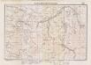
Lambert-Cholesky sheet 2374 (Cuzap)
1 : 20000 Romanian military topographic map sheet under Lambert-Cholensky projection Institutul Geografic Militar geo-spatial.org Institutul Geografic Militar
Lambert-Cholesky sheet 2472 (Vadul lui CAROL II)
1 : 20000 Romanian military topographic map sheet under Lambert-Cholensky projection Institutul Geografic Militar geo-spatial.org Institutul Geografic Militar
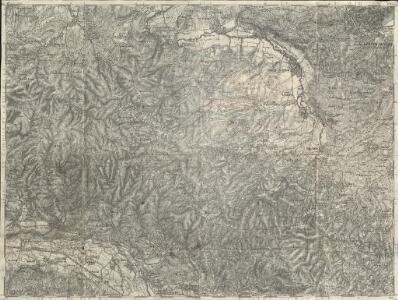
Szilagy-Somlyo und Elesd.
from Spezialkarte der osterreichisch-ungarischen Monarchie.
Lambert-Cholesky sheet 2572 (Tusa)
1 : 20000 Romanian military topographic map sheet under Lambert-Cholensky projection Institutul Geografic Militar geo-spatial.org Institutul Geografic Militar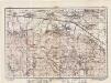
Lambert-Cholesky sheet 2372 (Aştileu)
1 : 20000 Romanian military topographic map sheet under Lambert-Cholensky projection Direcția Topografică Militară geo-spatial.org Direcția Topografică Militară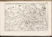
C. Bihariensis. Tab. I
Ungarn Rumänien Komitat Bihar
Szilágy vármegye térképe
1 : 360000 Kogutowicz, Manó Magyar Földrajzi Intézet
Tasnad und Szeplak.
from Spezialkarte der osterreichisch-ungarischen Monarchie.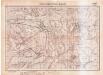
Lambert-Cholesky sheet 2475 (Camăr)
1 : 20000 Romanian military topographic map sheet under Lambert-Cholensky projection Serviciul Geografic al Armatei geo-spatial.org Serviciul Geografic al Armatei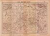
Lambert-Cholesky sheet 2375 (Toti)
1 : 20000 Romanian military topographic map sheet under Lambert-Cholensky projection Serviciul Geografic al Armatei geo-spatial.org Serviciul Geografic al Armatei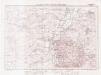
Lambert-Cholesky sheet 2575 (Carastelec)
1 : 20000 Romanian military topographic map sheet under Lambert-Cholensky projection Institutul Geografic Militar geo-spatial.org Institutul Geografic Militar
Süd-Biharer Comitat
1 : 290000 Bihor (Rumunsko)
Süd-Biharer Comitat
1 : 288000 Bihor (Rumunsko : judet)
Süd-Biharer Comitat
1 : 288000 Bihor (Rumunsko)
Vermehrte und Verbesserte Landkarten des Königreichs Ungarn :
1 : 500000 Mollova mapová sbírka Stier, Martin Böner, Johann-Alexander Endter, Martin
Partis Hungariae Inter Tibiscum et Nigrum Chrysum Nova et Accurata Descriptio
1 : 530000 Mollova mapová sbírka Valk, Gerhard Schenk, Peter I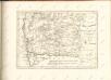

Rumänen in Ost-Ungarn 1941
Ungarn (Ost) Rumänen, Siedlung Bottlik, Zsolt
Rumänen in Ost-Ungarn 1880
Ungarn (Ost) Rumänen, Siedlung Bottlik, Zsolt
Rumänen in Ost-Ungarn 1980
Ungarn (Ost) Rumänen, Siedlung Bottlik, Zsolt
Sheet IX: Karte Des Oesterreichischen Kaiserstaates.
1 : 576000 Scheda, Josef
A rományok aránya és száma Kelet-Magyarországon 1941-ben
Ungarn (Ost) Rumänen, Siedlung Bottlik, Zsolt
A rományok aránya és száma Kelet-Magyarországon 1980-ban
Ungarn (Ost) Rumänen, Siedlung Bottlik, Zsolt