Maps of Ljubljana

Laibach
1 : 75000 Ljubljana
Laibach

Grundriss der Haupt-Stadt Laibach im Königreiche Illyrien
Deschmann, Franz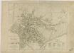
Grundriss der Haupt-Stadt Laibach

Plan der Stadt Laibach

Einödblöckeflur mit Gehöftgruppensiedlung im Tertiärhügelland von Stein
Oberkrain, Kamnik, Siedlungsform
Übergang von gewannartiger Streifenflur zur echten Blockflur in den Rieden Raune u. Fuschine der Gemeinde Koschische
Oberkrain, Kamnik, Flurform
Übergang von der Einöd- zur Blockflur im Tertiärhügelland von Stein bei Koschische, verbunden mit Gehöftgruppensiedlung
Oberkrain, Kamnik, Flurform
Yugoslavia 1:100,000, Ljubljana
Yugoslavia 1:100,000 , Series GSGS 4396. Great Britain. War Office. [London] : War Office
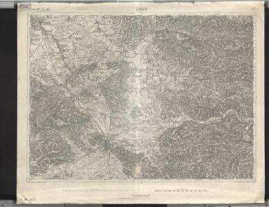
Laibach.
from Spezialkarte der osterreichisch-ungarischen Monarchie.
Inselhafte Waldverbreitung in der Ebenen-Gemeinde Michelstetten am Südrand der Steiner Alpen
Steiner Alpen, Velesovo, Siedlungsform
Naseljenost prebivalstva na Kranjskem
1 : 400000 Kraňsko Lončar, Dragotin Kaisvinkler, Bohumil

Übersicht der Krainer Metulum-Hypothesen
1 : 750000 Kroatien Ogulin (Region) Illyrien Augustus

Unter Krain
1 : 500000 Unterkrain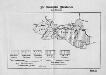
Die slovenischen Mundarten
Drau-Gebiet Slowenisch, Mundart
Dioecesan-Carte von Laibach
1 : 260000 Lublaň-oblast (Slovinsko) Mascon, Johann Wolf, Anton Alojzij Johann Mascon
Aus der Übersichtskarte von Mittel-Europa 1:750 000
1 : 750000 Evropa střední K. k. Österreichische Staatsbahnen
Ljubljana
1 : 200000 Lublaň (Slovinsko : oblast) Kartografska radionica
Neueste special Karte des Cillier Kreises im Herzogthume Steyermark
1 : 210000 Celje (Slovinsko) Kaiser, Joseph Franz Jos. Fr. Kaiser
Neueste special Karte des Cillier Kreises im Herzogthume Steyermark
1 : 210000 Štýrsko (Rakousko) Kaiser, Jos. Fr. Jos. Fr. Kaiser
Neueste special Karte des Cillier Kreises im Herzogthume Steyermark
1 : 220000 Celje (Slovinsko) Kaiser, Joseph Franz Jos. Fr. Kaiser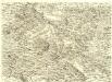
Ducatus Carnioliae Tabula Chorographica Iusu Sumptuque inclytorum Provinciae Statuum.
1 : 100000 Mollova mapová sbírka Florjančič de Grienfeld, Janez Dizma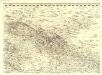
Ducatus Carnioliae Tabula Chorographica Iusu Sumptuque inclytorum Provinciae Statuum.
1 : 100000 Mollova mapová sbírka Florjančič de Grienfeld, Janez Dizma
Eisenkappel und Kanker.
from Spezialkarte der osterreichisch-ungarischen Monarchie.
Die Siedlungsformen des südlichen Jauntals, der nördlichen oberkrainischen Ebene, sowie der Steiner Alpen und Ost Karawanken, n.d. Franziszeischen Kataster 1825-1828
1 : 115200 Oberkrain Siedlungsform
Italy 1:100,000 / Sardinia 1:100,000, Idria
Italy 1:100,000 / Sardinia 1:100,000 , Series GSGS 4164. Great Britain. War Office. General Staff. Geographical Section. [London] : War Office
Weixelburg und Zirknitz.
from Spezialkarte der osterreichisch-ungarischen Monarchie.