Maps of Central Russian Upland

Srednerusskaja černozemnaja oblast' v XIV-XVII v.v: XV-XVII věka
Russland Zentralrussland
Gustota naselenīja srednerusskoj černozemnoj oblasti
Russland Zentralrussland Bevölkerungsdichte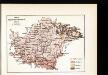
Plemena srednerusskoj černozemnoj oblasti
Russland Zentralrussland Ethnische Gruppe
Krěpostnoe sostojanīe srednerusskoj černozemnoj oblasti v polovině XIX věka
Russland Zentralrussland Russland / Bauernbefreiung <1861>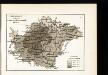
Raspachannost zemel' srednerusskoj černozemnoj oblasti
Russland Zentralrussland Bodenertrag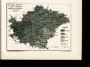
Raspredělenīe temperatury v ījulě i količestva osadkov zimoju v srednerusskoj černozemnoj oblasti
Russland Zentralrussland Klima Temperatur Juli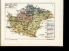
Geologičeskoe stroenīe srednerusskoj černozemnoj oblasti po kart Geol. Komiteta
Russland Zentralrussland Geologie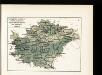
Raspredělenīe temperatury v janvarě i količestva osadkov zimoju v srednerusskoj černozemnoj oblasti
Russland Zentralrussland Klima Temperatur Januar
Obezpečennost' sel'skago naselenīja prodovol'stv. chlěbom v srednerusskoj černozemnoj oblasti
Russland Zentralrussland Landwirtschaft
Ljudnost' selenīj v srednerusskoj černozemnoj oblasti
Russland Zentralrussland Bevölkerung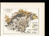
Počvy srednerusskoj černozemnoj oblasti po N. Sibircevu
Russland Zentralrussland Bodenkartierung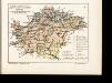
Rastitel'nyj mir srednerusskoj černozemnoj oblasti
Russland Zentralrussland Bewaldung Pflanzengeografie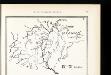
Srednerusskaja černozemnaja oblast' v IX-XIII v.v: IX-XI věka
Russland Zentralrussland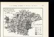
Uveličenīe količestva naselenīja s 1851 po 1897 g.g. v srednerusskoj černozemnoj oblasti
Russland Zentralrussland Bevölkerungsentwicklung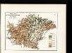
Relef srednerusskoj černozemnoj oblasti po A. Tillo
Russland Zentralrussland Relief
Karta srednerusskoj černozemnoj oblasti
Russland Zentralrussland Topografie
Zasěčnyja čerty.
Russland Krieg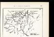
Srednerusskaja černozemnaja oblast' v XIV-XVII v.v: XIV-XV věka
Russland Zentralrussland
Schema dviženīja lěsnoj stichīi v step v istoričeskīja vremena
Russland Zentralrussland Bewaldung Steppe Pflanzengeografie
Schema podrazdělenīj srednerusskoj i okružajuščich vozvyšennostej i nizmennostej
Russland Geografie
Srednerusskaja černozemnaja oblast' v IX-XIII v.v: XI-XIII věka
Russland Zentralrussland

Russia in Europe Part VI.
1 : 2100000 Society for the Diffusion of Useful Knowledge (Great Britain)
Russia 6.
1 : 2217600 Letts, Son & Co.
Des Russischen Reiches Statthalterschaften Woronesch, Belgorod Kiow o. Kleinrussland und Charkow od.
1 : 4000000 1 Karte : Kupferdruck ; 20 x 26 cm Reilly, Franz J. J. von [F. J. J. von Reilly]
Im Stillstand von Deulino 1618 an Polen abgetretene Gebiete
1 : 8250000 Moskauer Reich Polnisch-Russischer Krieg <1609-1618>, Gebietsverlust
Partie, Russie d'Europe. Europe 16.
1 : 1641836 Vandermaelen, Philippe, 1795-1869
Schema dviženīja russkoj rati s 20 avgusta po 7 sentjabrja 1380 g.
Russland Kulikovo Pole Kulikowo Pole / Schlacht Dmitri, Moskau, Großfürst
Schema ovražistosti južnoj časti Okskago bassejna v predělach Rjazanskoj gub.
Russland Oka


