Maps of Mediterranean Sea

L'Empire Grec en 1190 et l'Hellenisme pendant l'occupation latine de Constantinople [Nebenkarte]
Byzantinisches Reich Lateinisches Kaiserreich Konstantinopel Hellenismus Kümmerly & Frey
Levante Dienst
Středozemní moře-oblast východní
Cesta Israelitů z Egypta a cesty sv. Pavla

Countries Traveled by the Apostles. (1826)
1 : 9900000 Tanner, Henry S.
Orbis Romani pars orientalis, auspiciis serenissimi principis Ludovici Philippi Aurelianorum ducis publici juris facta
1 : 4300000
Peregrinationis divi Paulitypus Corographicus
Geographische beschryvinghe van de wandeling der apostelen ende de reysen Pauli, : mitsgaders de landen ende rijcken daer sij het Evangelium eerst hebben verkondight, / nieuwlijcx int licht gebracht door Nicolaes Visscher ; A. vanden Broeck sculp
1 : 7000000 Annotatie: Kaart van het oostelijk deel van de Middellandse Zee, omringd door 9 gravures van de reizen van Paulus; Rechtsonder genummerd: 6; Origineel is Blad 184 in atlas factice; Annotatie geografische gegevens: Met 2 schaalstokken Nicolaes Jansz Visscher sr 1618-1679; Abraham van den Broeck ca. 1616-1688 [Amsterdam : Nicolaas Visscher]
L'Empire Grec en 1190 et l'Hellenisme pendant l'occupation latine de Constantinople [Hauptkarte]
Byzantinisches Reich Lateinisches Kaiserreich Konstantinopel Hellenismus Kümmerly & Frey
De landen van 't Romeinsche gebied in welke de Christen kerk, kort na Christus hemelvaard, door den dienst der apostelen is uitgebreid : tot verklaringe van de Handelingen der Apostelen
1 : 6500000 afgebeeld door W.A. Bachiene J. van Jagen mapp. sculpsit, et figur. apposit sculpturam curavit ; S. Fokke fecit. Uitgegeven te Gorinchem : by Nicolaas Goetzee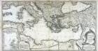
Theatre de la guerre entre les Russiens et les Turcs
1 Karte auf 2 Blatt : Kupferdruck ; 50 x 93 cm Roth C. M. Roth
Die Türkey
Evropa jihovýchodní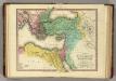
Patriarchati Orientales. (1826)
1 : 19000000 Tanner, Henry S.
Orientalior districtus Maris Mediterranei
1 Karte : Kupferdruck ; 47 x 58 cm Renard apud L. Renard
Tabula geographica ad acta aposto
Středozemní moře-oblast východní Berka, Jan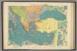
E. Mediterranean.
1 : 5000000 Philip, George
Das Oströmische Reich zur Zeit Karls des Gr.
Byzantinisches Reich
Das Oströmische Reich zur Zeit Karls des Gr.
Byzantinisches Reich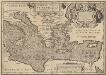
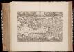
Aeneae Troiani Navigatio Ad Virgilii Sex priores Aeneidos. [Karte], in: Theatrum orbis terrarum, S. 532.
1 Karte aus Atlas Ortelius, Abraham Vrients, Jan Baptista
Pascaarte Van't Oostelyckste deel vande Middelandsche Zee [...] [Karte], in: Het vijfde Deel Des Grooten Atlas : Vervatende De Water-Weereld, S. 223.
1 Karte aus Atlas Jansson, Jan Jansson, Jan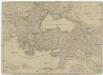
Europaeische und asiatische Türkey
1 : 7100000 Blízký východ Mollo, Tranquillo T. Mollo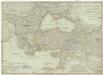
Europaeische und asiatische Türkey
1 : 7100000 Evropa jihovýchodní Mollo, Tranquillo Tranquillo Mollo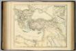
Turkish Empire.
1 : 5702400 Fullarton, A. & Co.
Süd-Europa & Vorder-Asien zur Zeit der Kreuzzüge
Südosteuropa, Byzantinisches Reich, Kreuzzüge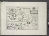
A new map shewing all the severall countries, cities, towns and other places mentioned in the New Testament [1 - in Greece Cyprus, Asia and parts adjoining; 2 - in Italy, Mesopotamia &c.; 3 - in the Holy Land and parts adjoining.]
from A new sett of maps both of antient and present geography : wherein not only the latitude and longitude of many places are corrected according to the latest observations, but also the most remarkable differences of antient and present geography may be quickly discern'd by a bare inspection or comparing of correspondent maps, which seems to be the most natural and easy method to lead young students (for whose use the work is principally intended) unto a competent knowledge of the geographical science : together with a geographical treatise particularly adapted to the use and design of these maps / by Edward Wells, M.A. and student of Christ-Church, Oxon.
[134][137] Orientalior districtus Maris Mediterranei ..., uit: Atlas sive Descriptio terrarum orbis
Annotatie: Gedigitaliseerde versie. Amsterdam. Heiloo : Picturae (vervaardiger), 2015. tiff-bestand. Gedigitaliseerd: 07-01-2015; Origineel: Universiteitsbibliotheek Vrije Universiteit (XL.05127.-) ; Netherlands; Titelpagina ontbreekt Wit, Frederik de Amsterdam : Frederick de Wit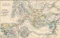
Die Zeit der Kreuzzüge
Südeuropa, Mittelmeerraum, Kreuzzüge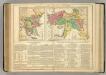
Turkey.
1 : 7800000 Lavoisne, M.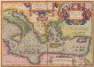
Aeneae Troiani Navigatio Ad Virgilii Sex priores Aeneidos. [Karte], in: Theatrum orbis terrarum, S. 448.
1 Karte aus Atlas Ortelius, Abraham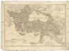
Europaeische und asiatische Türkey
1 : 3530000 Evropa jihovýchodní Mollo, Tranquillo T. Mollo
![L'Empire Grec en 1190 et l'Hellenisme pendant l'occupation latine de Constantinople [Nebenkarte]](https://images-2.georeferencer.com/images/iiif/310395407735/full/,300/0/native.jpg)

