Maps of Splitsko-Dalmatinska
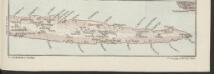
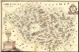
Lesina [Osthälfte]
1 : 200000 Kroatien Hvar
Ravca und Zastrazisce.; Spezialkarte der osterreichisch-ungarischen Monarchie.
from Spezialkarte der osterreichisch-ungarischen Monarchie. Austro-Hungarian Monarchy. Militärgeographisches Institut.,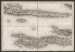
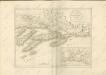
[Kanal von Korčula]
Kroatien Dalmatien Korčula Umland
Adriatisches Meer, Küstenkarte
1 : 180000 Hvar (Chorvatsko : ostrov) Oesterreicher, Tobias von Hydrographisches Amt der k. u. k. Kriegs-Marine
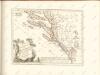
Charte des sudöstlichen Theiles von Dalmatien mit dem Oesterreichischen Antheile von Albanien
1 : 540000 Albánie Kipferling, Karl Joseph
Střední Dalmacie
1 : 750000 Dalmácie střední (Chorvatsko) Machát, František c. a k. voj. zeměpisný ústav
Charte des sudöstlichen Theiles von Dalmatien mit dem oesterreichischen Antheile von Albanien
Albánie im Verlage des Kunst und Industrie Comptoirs
Partie de la Dalmatie du sud est avec l'Albanie
Albánie im Verlage des Kunst und Industrie Comptoirs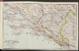
Die adriatische Küste von Spalato bis Cattaro
1 : 900000 Kroatien Adriaküste
Skelet-Karte für Curs-Skizzen
Chorvatsko K. u. k. Kriegs-Marine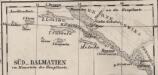
Süd-Dalmatien
Dalmatien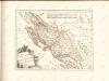

Eisenbahnkarte der k.u.k. oesterreichisch-ungarischen Monarchie

Ragusa, Mostar
1 : 750000 Dubrovník (Chorvatsko : oblast) Nimmerfroh, J. K. u. k. Militärgeographisches Institut
Ragusa, Mostar
1 : 750000 Dubrovník (Chorvatsko : oblast) K. u. k. militär-geografisches Institut
Ragusa, Mostar
1 : 750000 Dubrovník (Chorvatsko : oblast) K. k. militär-geographisches Institut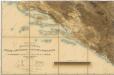
Hypsometrische uibersichtskarte von Bosnien der Herzegovina von Serbien und Montenegro
Der Südliche Theil des Koenigreichs Dalmatien mit der Republik Ragusa
1 : 1000000 Dalmatien, Dubrovnik
Südlicher Teil von Dalmatien
Dalmatien (Süd)
Dalmatien und seine Hinterländer
1 : 1700000 Kroatien Dalmatien Bosnien Herzegowina
Übersichtskarte von Mittel - Europa

Sheet XVIII: Karte Des Oesterreichischen Kaiserstaates.
1 : 576000 Scheda, Josef
Dalmatien und Montenegro
Kroatien, Montenegro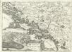
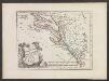
Regnum Dalmatiae
1 : 1200000 Mollova mapová sbírka Bruggen, Johann van der Brugge, Johannes van der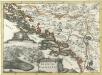
Regnum Dalmatiae
1 : 1200000 Mollova mapová sbírka Bruggen, Johann van der Brugge, Johannes van der
XVIII, uit: General-Karte des oesterreichischen Kaiserstaates mit einem grossen Theile der angrenzenden Länder / durch Josef Scheda ... bearb. und hrsg
1 : 576000 Annotatie geografische gegevens: Maatstokken: oesterreichische Meilen, geografische oder deutsche Meilen, preussische Meilen, türkische Berri, französische Lieues, russische Werste; Maatstok per blad: wiener Klafter, öster. Meilen; Blad XIX: statistische en taalkundige informatie; Blad XIX: legenda [Wien : K.K. Militärisch-Geografisches Institut]
Bez titulu: Istrie a Dalmatské pobřeží
![Lesina [Osthälfte]](https://images-2.georeferencer.com/images/iiif/235568268885/full/,300/0/native.jpg)

