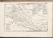
Maps of Medimurska
C. Szaladiensis. Tab. I
Ungarn Komitat Zala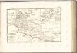
Stÿriae Ducatus Fertilisimi Nova Geographica Descriptio
1 : 200000 Mollova mapová sbírka Vischer, Georg Matthaeus Trost, Andreas
Also-Lendva und Lenti.
from Spezialkarte der osterreichisch-ungarischen Monarchie.
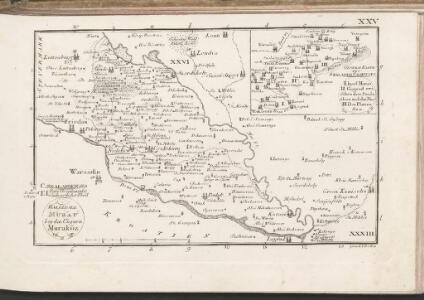
Warasdin
1 : 75000 Varaždin, Varaždin (Region)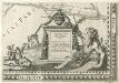
Stÿriae Ducatus Fertilisimi Nova Geographica Descriptio
1 : 200000 Mollova mapová sbírka Vischer, Georg Matthaeus Trost, Andreas
Warasdin und Kotor.; Spezialkarte der osterreichisch-ungarischen Monarchie.
from Spezialkarte der osterreichisch-ungarischen Monarchie. Austro-Hungarian Monarchy. Militärgeographisches Institut.,
Alsó Lendva
1 : 75000 Lendava, Lendava (Region)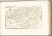
C. Szaladiensis. Tab. II
Ungarn Komitat Zala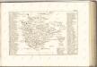

Pettau und Vinica.
from Spezialkarte der osterreichisch-ungarischen Monarchie.
Radkersburg und Luttenberg.
from Spezialkarte der osterreichisch-ungarischen Monarchie.
G. Kanizsa und Zakany.
from Spezialkarte der osterreichisch-ungarischen Monarchie.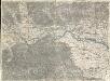
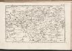
Pettau
1 : 75000 Ptuj, Ptuj (Region)
Zone 20, Col. XIV, Pettau und Vinica, uit: Geologische Karte der im Reichsrathe vertretenen Königreiche und Länder der Österreich-Ungarischen Monarchie : auf Grundlage der Specialkarte i.M. 1:75.000 des k.u.k. Militär-geographischen Institutes / neu bearb. und als Kartenwerk von 341 Blattnummern in zwanglosen Lfg. hrsg. durch die k.k. Geologische Reichsanstalt in Wien
1 : 75000 titelvariant: Geologische Spezialkarte der im Reichsrate vertretenen Königreiche und Länder der Österreichisch-Ungarischen Monarchie; Geologische Specialkarte der im Reichsrathe vertretenen Königreiche und Länder der Österreichisch-Ungarischen Monarchie; Annotatie: Titel bovenaan kaartblad: Geologische Spezialkarte der im Reichsrate vertretenen Königreiche und Länder der Österreichisch-Ungarischen Monarchie en Geologische Specialkarte der im Reichsrathe vertretenen Königreiche und Länder der Österreichisch-Ungarischen Monarchie; Annotatie geografische gegevens: Coördinaten gebaseerd op nulmeridiaan van Ferro (Hierro) Kaiserlich-Königliche Geologische Reichsanstalt, Wenen Wien : K.K. Geologische Reichsanstalt
Radkersburg
1 : 75000 Bad Radkersburg
Kis-Komarom und Zala-Szt.-Mihaly.
from Spezialkarte der osterreichisch-ungarischen Monarchie.
Nagykanizsa
1 : 75000 Nagykanizsa, Nagykanizsa (Region)
Yugoslavia 1:100,000, Ptuj
Yugoslavia 1:100,000 , Series GSGS 4396. Great Britain. War Office. [London] : War Office
Kis-Komárom
1 : 75000 Komorn (Ungarn)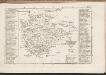
Eisemburger Com. Tab. II
Ungarn Komitat Vas
Tlovid Topličke okolice
1 : 13000 Varaždinske Toplice (Chorvatsko) Drag. Albrecht
Mappa Comitatvs Soproniensis 1758
1 : 1250000 Mollova mapová sbírka Zeller, Sebastian
Vermehrte und Verbesserte Landkarten des Königreichs Ungarn :
1 : 500000 Mollova mapová sbírka Stier, Martin Böner, Johann-Alexander Endter, Martin
Niederungern
Maďarsko západní Kipferling, Karl Joseph Berken von Ottendorff, Johann im Verlage des Kunst- und Industrie Comptoirs
Niederungern
Maďarsko západní Kipferling, Karl Joseph Berken von Ottendorff, Johann im Verlage des Kunst- und Industrie Comptoirs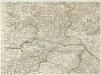
Augustissimo Romanor. Imperatori Iosepho I. Hungaria Regi Invictissimo Mappam Hanc Regni Hungariae
1 : 540000 Mollova mapová sbírka Müller, Johann Christoph
Ducatus Stiriae novissima tabula
1 : 470000 Štýrsko (Rakousko) Homann, Johann Baptist Vischer, Georg Matthaeus a Ioh. Bapti. Homanno
Geographischer Entwurff des Herzogthums Steyermarck nach Der neuen Eintheilung in 5. Creÿse und der perpetuirl. Marche-Route
1 : 460000 Mollova mapová sbírka Diettel, Christoph
Ducatus Styriae Tabula
1 : 950000 Mollova mapová sbírka Engelbrecht, Christian Engelbrecht, Martin
Ducatus Styriae Tabula
1 : 950000 Mollova mapová sbírka Pfeffel, Johann Andreas
Stiria Ducatus juxta recentissimas observationes et accuratissimas mappas commoda hac forma aeri sculptus et usui publico destinatus
1 : 475000 Mollova mapová sbírka Seutter, Matthäus Seutter, Matthäus
Ducatûs Stiriae Novissima Tabula ex ampliore mappa olim R.Dmi. Georgii Matth. Vischer, S.C.M. Leopoldi I. Glor. Mem. Geographi deducta
1 : 470000 Mollova mapová sbírka Homann, Johann Baptist Homann, Johann Baptista
Stiria Vulgo Steyrmarck
1 : 433300 Mollova mapová sbírka Schenk, Peter I
Styria
1 : 416000 Mollova mapová sbírka Blaeu, Willem Janszoon Blaeu, Willem Jansz.