Maps of District of Dunajská Streda
C. Posoniensis. Tab. II
Slowakei Komitat Preßburg
Petronell - Raab
Mollova mapová sbírka Marsili, Luigi Ferdinando
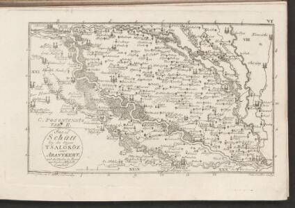
Duna-Szerdahely und Hedervar.
from Spezialkarte der osterreichisch-ungarischen Monarchie.
Mappa Comitatus Mosoniensis
Mollova mapová sbírka Kovács, János Nicolaï, Georg David Christoph
Moson vármegye
1 : 130000 Neziderské jezero (Maďarsko a Rakousko : oblast) Kováts, János Görög, Demeter Görög
Die Herrschaft Ungarisch Altenburg
1 : 146000 Mosonmagyaróvár (Maďarsko) David, Johann
Wartberg und Tallos (Ungarn).
from Spezialkarte der osterreichisch-ungarischen Monarchie.
Ung. Altenburg.
from Spezialkarte der osterreichisch-ungarischen Monarchie.
Umgebung von Pozsony
1 : 75000 Bratislava (Slovensko : oblast) K. u. k. Militärgeographisches Institut
III. vojenské mapování 4859
1 : 75000
Dunajská Streda
1 : 75000 Dunajská Streda (Slovensko : oblast) Vojenský zeměpisný ústav
Dun. Streda a Hédervár
1 : 75000 Dunajská Streda (Slovensko : oblast) Vojenský zeměpisný ústav
Duna-Szerdehely und Hédervár
1 : 75000 Dunajská Streda, Hédervár Geripp: Oberjgr. Richter. Terrain: Wachtm. R. v. Palitschek
Magyaróvár
1 : 75000 Maďarsko Vojenský zeměpisný ústav
Wartberg und Tallós
1 : 75000 Senec, Tomášikovo Geripp: Oberjgr. Spaczek. Terrain: J. Le Gay Edler v. Lierfels
III. vojenské mapování 4759
1 : 75000
Senec
1 : 75000 Senec-oblast (Slovensko) Vojenský zeměpisný ústav
Senec
1 : 75000 Senec (Slovensko : oblast) Vojenský zeměpisný ústav
Zone 13, Kol. XVII, Umgebung von Szempcz und Tallós, uit: [Geologische Specialkarte der im Reichsrathe vertretenen Königreiche und Länder der österreichisch-ungarischen Monarchie] / geologische Aufnahmen der königl. ung. Geologischen Anstalt
1 : 75000 Annotatie: Verantwoordelijkheidsvermelding in 1909 veranderd in: Königliche Ungarische Geologische Reichsanstalt; Sommige bladen in het Frans; Annotatie geografische gegevens: Coördinaten gebaseerd op nulmeridiaan van Ferro (Hierro) Königliche Ungarische Geologische Reichsanstalt; Königliche Ungarische Geologische Anstalt Budapest : [Königliche Ungarische Geologische Anstalt]
III. vojenské mapování 4858
1 : 75000
Ung. Altenburg
1 : 75000 Mosonmagyaróvár, Umland Geripp: Leutn. Kimlein. Terrain: Leutn. Sachs
Umgebung von Poszony

III. vojenské mapování 4860/3
1 : 25000
Komárno
1 : 75000 Slovensko Vojenský zeměpisný ústav
Komárno a Nové Zámky
1 : 75000 Slovensko Vojenský zeměpisný ústav
Komárno a Nové Zámky
1 : 75000 Slovensko Vojenský zeměpisný ústav
Presburg mit seinen Umgebungen
Bratislava-oblast (Slovensko) Zutz, Joseph
Pressburg und Hainburg.; Spezialkarte der osterreichisch-ungarischen Monarchie.
from Spezialkarte der osterreichisch-ungarischen Monarchie. Austro-Hungarian Monarchy. Militärgeographisches Institut.,
Pressburg und Hainburg
1 : 75000 Bratislava, Hainburg an der Donau Geripp: Assist. Jersche. Terrain: R. Bloschitz