Maps of Poland

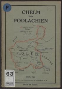
Chelm und Podlachien
Polen Chełm (Województwo) Podlachien Auner, H.
Die Lage Ende März
Polen Weltkrieg <1914-1918>, Ostfront
Übersichtsblatt zur Karte des westlichen Russlands
1 : 100000 Russland Weißrussland Grenzgebiet Kartogr. Abteilung der Kgl. Preuß. Landesaufnahme
Východní fronta 1914

Russische Gouvernementseinteilung vor der deutschen Besatzung
Baltikum Kurland (Gouvernement) Ėstljandskaja Gubernija Riga (Gouvernement)
Weichsel
Weichsel (Fluss), Flusslauf
Charte von Polen
1 : 2320000 Halič (Polsko a Ukrajina) bey Artaria
Charte von Polen
1 : 2320000 Halič (Polsko a Ukrajina) bey Artaria
Charte von Polen
1 : 2320000 Halič (Polsko a Ukrajina) Artaria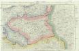
Neue militairische Situations- und Post-Carte von Polen und Preussen
1 : 900650 Polsko Knittel, I. E. Friedrich Campe
Poland. Polska.
1 : 1760000 Society for the Diffusion of Useful Knowledge (Great Britain)
Poland.
1 : 1774080 Letts, Son & Co.
Karte von Pohlen und den Umgebungen Warschaus
1 : 1950000 Polsko Hennig, C. C. Hennig
Karte von Pohlen und den Umgebungen Warschaus
1 : 1950000 Polsko Hennig, C. bei Bohmanns Erben
Karte von Pohlen und den Umgebungen Warschaus
1 : 1950000 Polsko Hennig, C. C. Hennig
Karte vom Herzogthum Warschau, und den angrenzenden Staaten in IV Sectionen
1 : 650000 Polsko Engelhardt, Friedrich Bernhard Mare, Carl Simon Schropp & Comp.
Uebersichts Karte von Ost und West Preussen und Polen

Königreich Polen

[Sarmatia]
1 : 6630000 1 Karte : Holzschnitt ; 8 x 14 cm Münster, Sebastian [Henricpetri]
Karte von Pohlen und den Umgebungen Warschaus
1 : 2000000 Polsko Seidler, C. C. Hennig
Karte von Pohlen und den Umgebungen Warschaus
1 : 2000000 Polsko Seidler, C. C. Hennig
Das Königreich Polen nebst den Königl. Preussischen Provinzen Preussen und Posen nebst dem Gebiete der freien Stadt Krakau
Preußen, Kongresspolen
[Neuer Atlas der ganzen Erde nach den neuesten Bestimmungen ... : XXI.] Das Königreich Polen und der Freistaat Krakau
Entworfen und gezeichnet von Dr. F.W. Streit Leipzig : J.C. Hinrichs'sche Buchhandlung
Polen.
1 : 1200000 Stein, Christ. Gottfr. Dan.
Nr. 12. Die Eroberung Polens
Polen Weltkrieg <1914-1918>, Eroberung
Preussen, Posen, Polen, Krakau.
1 : 5500000 Brudin, J. L.; Stieler, Adolf
Preussen und Polen
Schul-Atlas in 36 Karten Völter, Daniel Verlag der J.M. Dannheimer'schen Buchhandlung
Generalkarte vom Königreich Preussen
1 : 1200000 Polsko Sotzmann, Daniel Friedrich Schneider u. Weiglischen Kunst und Buchhandlung
Generalkarte vom Königreich Preussen
1 : 1200000 Polsko Sotzmann, Daniel Friedrich Schneider u. Weiglischen Kunst und Buchhandlung