Maps of Zenica-Doboj

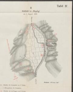
Gefecht bei Maglaj
1 : 250 Bosnien-Herzegowina Maglaj Gefecht
Gracanica und Tesanj.
from Spezialkarte der osterreichisch-ungarischen Monarchie.
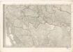
Generalkarte von Zentraleuropa
[Generalkarte von Bosnien und der Hercegovina] K. 10. (Brod)
1 : 300000 Bosnien-Herzegowina Bosnien
Franz Maurer ́s Routen in Bosnien 1868 nach dessen Skizzen und Reisetagebuch
Bosnien-Herzegowina, Bosnien, Reiseweg
Tabula Geographica Nova Et Exacta Distincte Exhibens Regnum Sclavoniae Cum Syrmii Ducatu Quod A Fluvus Savi Illovae Dravi Et Danubii Allitur Eius Provinitiae Conterminae Sunt Regnum Hungariae Croatiae Bosniae Serviae Et Bannatus Temesvrensis
Sirmien, Bosnien, Požarevac / Friede Khevenhüller-Frankenburg, Ludwig Andreas von, http://d-nb.info/gnd/116153849
Sclavonia. Bosnia
Mollova mapová sbírka Hoffmann, Johannes Hoffmann, Johann
Vermehrte und Verbesserte Landkarten des Königreichs Ungarn :
1 : 500000 Mollova mapová sbírka Stier, Martin Böner, Johann-Alexander Endter, Martin
Strassen-Karte der Slavonischen Militair Grenze
1 : 432000 Slavonie (Chorvatsko)
Tabvla Geographica exhibens Regnvm Sclavoniae cum Syrmii Ducatu Ex mappa grandiori desumta et in lucem
1 : 610000 Mollova mapová sbírka Homann, Johann Baptist Homann, Johann Baptista - dědici
Strassen-Karte der slavonischen Militair Grenze
1 : 440000 Bosna a Hercegovina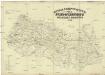
Strassen-Karte der Slavonischen militair Grenze
1 : 440000 Bosna a Hercegovina
Reg. Bosniae
1 : 875000 Mollova mapová sbírka Bruggen, Johann van der Brugge, Johannes van der
Reg. Bosniae
1 : 875000 Mollova mapová sbírka Pfeffel, Johann Andreas Pfeffel, Johann Andreas I.
Zagreb, Brod, Osijek, Glina, Knin, Sarajevo
1 : 750000 Glina (Chorvatsko) Cronenberg, E. K. u. k. Militärgeographisches Institut
Agram, Brod, Esseg, Glina, Knin, Sarajevo
1 : 750000 Glina (Chorvatsko) K. u. k. Militärgeographisches Institut
Übersichtskarte von Mittel - Europa
Mappa generalis regni Hungariae partiumque adnexarum Croatiae, Slavoniae...

Übersichtskarte von Mittel - Europa

Dalmatien und Montenegro
Kroatien, Montenegro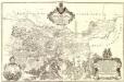
Tabula Geographica Nova et Exacta Distincte exhibens Regnum Sclavoniae cum Syrmii Ducatu
1 : 300000 Mollova mapová sbírka Gadea, Joseph Schmuzer, Johann Adam Schmuzer, Johann Andreas
XIII, uit: General-Karte des oesterreichischen Kaiserstaates mit einem grossen Theile der angrenzenden Länder / durch Josef Scheda ... bearb. und hrsg
1 : 576000 Annotatie geografische gegevens: Maatstokken: oesterreichische Meilen, geografische oder deutsche Meilen, preussische Meilen, türkische Berri, französische Lieues, russische Werste; Maatstok per blad: wiener Klafter, öster. Meilen; Blad XIX: statistische en taalkundige informatie; Blad XIX: legenda [Wien : K.K. Militärisch-Geografisches Institut]
General-Karte des gesammten Insurrections-Gebietes in Bosnien der Hercegovina und Süd-Dalmatien nebst den angrenzenden Ländern Montenegro, Novi-Bazar u. Serbien
1 : 420000 Bosna A. Hartleben's Verlag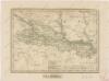
Slavonsko

Königreich Slavonien
1 : 770000 Slavonie (Chorvatsko) Tranquillo Mollo
Koenigreich Slavonien
1 : 828000 Slavonie (Chorvatsko) Mollo, Tranquillo Tranquillo Mollo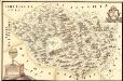
Mapa Particvlaris Regni Bosniae
Mollova mapová sbírka Geyer
Agram, Brod, Esseg, Glina, Knin, Sarajevo
1 : 750000 Knin (Chorvatsko : oblast) K. u. k. militär-geographisches Institut
Agram, Brod, Esseg, Glina, Knin, Sarajevo
1 : 750000 Glina (Chorvatsko) K. k. militär-geographisches Institut