Maps of Central Serbia

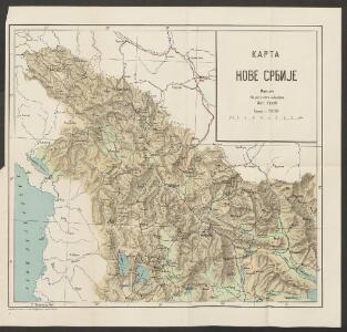
Karta Nove Srbije
1 : 1200000 Serbien Makedonien Bukarest / Friede <1913> Staatsgrenze Lazić, Ant.
Internationale Weltkarte 1:1.000.000
1 : 1000000 Evropa jihovýchodní War Office
Makedonien
1 : 1200000 Makedonie
Vilayet Prizren/Kosovo (1868-1913)
Kosovo Ejalet, Verwaltungsgliederung Zwick, J. ; Frantz, E.
Theatre de la Guerre dans le Royaume de Servie en Originale
Mollova mapová sbírka Weingartner, Johann Heckenauer, August Ferdinand
Makedonien, Altserbien und Albanien
1 : 864000 Albánie Peucker, Karl Artaria
Makedonien, Altserbien und Albanien
1 : 864000 Albánie Peucker, Karl Cvijić, Jovan Artaria
Makedonien, Altserbien und Albanien
1 : 864000 Albánie Peucker, Karl Cvijić, Jovan Artaria
Makedonien, Altserbien und Albanien
1 : 864000 Albánie Peucker, Karl Cvijić, Jovan Artaria
H.8. Skoplje, uit: [Übersichtskarte von Europa 1:750.000]
1 : 750000 Wien : K.u.K. Militärgeographisches Institut
Südöstlicher Kriegsschauplatz. Serbien
1 : 5000000 Serbien Weltkrieg <1914-1918>
Übersichtskarte der projectirten Eisenbahnlinie zwischen der Donau und Saloniki
1 : 1000000 Donau Eisenbahnnetz Hahn, Johann Georg von ; Kiepert, H.
Internationale und nationale Grenzen in der Provinz Makedonien seit 1944
Makedonien Grenzen
La Serbie de 1913
Serbien Geschichte
Siedlungsgebiet der Albaner
Balkanhalbinsel Albaner, Siedlung

Übersichtskarte von Mittel - Europa

Atlas
Albanien
Das Sandschak Novi Bazar, Nord-Albanien, Neu-Serbien u[nd] Montenegro
1 : 864000 Albánie Steinhauser, Anton Artaria
Stellungen der Armeen vor und während der Schlacht an der Bregalnica (und unmittelbar nach derselben)
Makedonien Bregalnica-Gebiet Balkankrieg <1912-1913>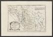
Der Noerdliche Theil Des Koenigreichs Albanien mit dem Distrikte Montenegro
1 : 1400000 Albanien, Montenegro
Carte de la Macédoine d'une partie de l'Albanie, de l'Epire et de la Thessalie
1 : 800000 Albánie Lapie, Pierre Kaeppelin Société geologique de France
Karte der Flußgebiete des Drin und des Wardar
1 : 500000 Vardar-Gebiet Flusssystem Hahn, Johann Georg von
Veles, Priština, Scutari
1 : 750000 Priština (Kosovo) Konrad, A. Erben, Fr. K. u. k. Militärgeographisches Institut
Novus Atlas
Albanien
Atlas
Albanien
Turquie d'Europe
Albanien Osmanisches Reich Reich
Demarkationslinie vor Beginn der Kriege gegen die Bulgaren
Südosteuropa Balkankrieg <1912-1913> Grenze
Rascien
1 : 800000 Sandschak Novi Pazar , Kosovo