Maps of Central Serbia
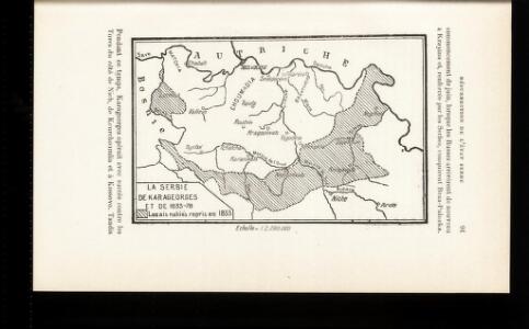
La Serbie de Karageorges et de 1833-78
Serbien Geschichte
Administrative Gliederung Serbiens in Kreise und Bezirke 1902
Serbien Verwaltungsgliederung
Bevölkerungsdichte 1900 (administrative Gliederung von 1902)
Serbien Bevölkerungsdichte
Karta knjažestva Serbie
1 : 375000 Srbsko Bugarski, Iovan Rau, J.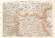
G. Freytags Karte des nördlichen Serbien
1 : 600000 Bosna a Hercegovina Freytag, Gustav G. Freytag & Berndt
Serbien
1 : 800000 Srbsko Kiepert, Heinrich Bugarski Geographisches Institut
Zemljepis od Serbije
1 : 822000 Srbsko Nipočić, Vasilij u c. k. Politechničeskoj inščotugu
Zemljepis od Serbie
1 : 830000 Srbsko Nipočić, Vasilij u c. k. Politechničeskoj inščotugu
La Serbie de 1878
Serbien Geschichte
Karta Serbije
1 : 575000 Srbsko Bilic, F. Kocebu
Knjažestvo Srbije
1 : 493000 Srbsko Milenkovie, Iovan
Administrative Gliederung Serbiens in Kreise und Bezirke 1890 (1891)
Serbien Verwaltungsgliederung
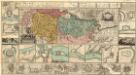
Sheet XIX: Karte Des Oesterreichischen Kaiserstaates.
1 : 576000 Scheda, Josef
Servia. Coal Resources of the World.
1 : 1500000 Milojkovitch, J.A.
Eisenbahnbau 1884-1915
Serbien Eisenbahnnetz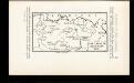
Pachalik de Belgrade 1800
Serbien Osmanisches Reich Belgrad Verwaltungsbezirk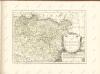
Regnum Bosniae, una cum finitimis Croatiae, Dalmatiae, Slavoniae, Hung. et Serviae partibus praecipuorum in his regionibus munimentorum ichnographia Curantibus
1 : 840000 Mollova mapová sbírka Ötinger, Johann Homann, Johann Baptista - dědici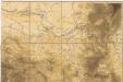
Hypsometrische uibersichtskarte von Bosnien der Herzegovina von Serbien und Montenegro

Theatrum belli inter imperat. Carol VI. et sult. Achmet IV. in partibus regnorum Serviae et Bosniae
Bulharsko Oettinger, Johann Friedrich Hommanianis Heredibus
Übersichtskarte von Mittel - Europa
Carte militaire et itineraire du royaume de Servie
1 : 640000 Srbsko Löschenkohl, Johann Hieronymus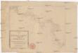
Die Shiffahrt auf der Donau von der Spitze Syrmiens bis in das Schwarze Meer
Bělehrad (Srbsko)
Strassen-Carte der Slawon. Militär-Gränze o. I. u. O
1 : 430000 Srbsko
Zemun, Orsova, Belgrad, Užice
1 : 750000 Bělehrad (Srbsko : oblast) Holl, W. K. u. k. Militärgeographisches Institut
Semlin, Alt-Orsova, Belgrad, Užice
1 : 750000 Bělehrad (Srbsko : oblast) Holl, W. K. u. k. militär-geographisches Institut
Semlin, Alt Orsova, Belgrad, Užice
1 : 750000 Bělehrad (Srbsko : oblast) K. k. militär-geographisches Institut
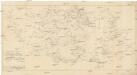
Nordost-Serbien
Serbien