Maps of Macedonia

Stellungen der Armeen vor und während der Schlacht an der Bregalnica (und unmittelbar nach derselben)
Makedonien Bregalnica-Gebiet Balkankrieg <1912-1913>
Karta Nove Srbije
1 : 1200000 Serbien Makedonien Bukarest / Friede <1913> Staatsgrenze Lazić, Ant.
H.8. Skoplje, uit: [Übersichtskarte von Europa 1:750.000]
1 : 750000 Wien : K.u.K. Militärgeographisches Institut
Izvod ot etnografskata karta na Mekenzi i Erbi
Makedonien Ethnische Gruppe
[Bălgarska zemja v Makedonija]
Makedonien Ethnische Gruppe Bulgaren
Izvod ot etnografskata karta na Ležana
Makedonien Ethnische Gruppe
[Mazedonien]
Makedonien
Demarkationslinie vor Beginn der Kriege gegen die Bulgaren
Südosteuropa Balkankrieg <1912-1913> Grenze
[Mazedonien]
Makedonien
[Macedonien]
1 Karte : Kupferdruck ; 18 x 13 cm [Trattner]
Theatrum belli inter imperat. Carol VI. et sult. Achmet IV. in partibus regnorum Serviae et Bosniae
Bulharsko Oettinger, Johann Friedrich Hommanianis Heredibus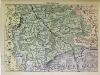
Süd-Serbien
1 : 800000 Serbien (Süd)
Ligne de partage d'après la carte annexée au traité d'alliance
Balkanhalbinsel Grenze Balkankrieg <1912-1913> Annexion
Ligne de partage d'après la carte annexée au Traité d'Alliance
Bulgarien Serbien Balkankrieg <1912-1913> Territorialer Anspruch Th. Weinreb del.
Westliches Mazedonien
1 : 600000 Makedonien (Landschaft)
Generalkarte von Zentraleuropa

Generalkarte von Zentraleuropa

Vormarsch der 1. Armee nach der Schlacht bei Kumanowo bis zur Schlacht bei Bitolj (Monastir)
Makedonien Balkankrieg <1912-1913> Kumanovo / Schlacht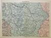
Mittel-Serbien
1 : 875000 Serbien
Generalkarte von Zentraleuropa

Stellungen der Armeen nach der Schlacht an der Bregalnica
Makedonien Bregalnica-Gebiet Balkankrieg <1912-1913>
Niš
1 : 200000 Niš (Srbsko) Vojni Geografski Institut Kraljevine
Niš
1 : 200000 Niš (Srbsko : oblast) Kartografska radionica
Niš
1 : 200000 Niš (Srbsko : oblast) Vojni Geografski Institut Kraljevine
Solun
1 : 200000 Soluň (Řecko) Kartografska radionica
Niš
1 : 200000 Niš (Srbsko : oblast) Militärgeographisches Institut
Džumaja
1 : 200000 Bulharsko Kartografska radionica
Kriva Palanka
1 : 200000 Kriva Palanka (Makedonie) Militärgeographisches Institut
Vodena
1 : 200000 Kartografska radionica


