Maps of Gnjilane

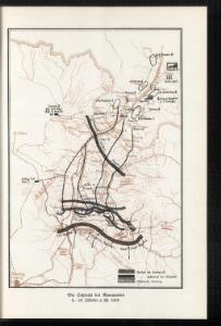
Die Schlacht bei Kumanowo 9.–10. Oktober a. St. 1912
Makedonien Balkankrieg <1912-1913> Kumanovo / Schlacht
Plan grada Skoplja
1 : 7500 Skopje (Makedonie) Zadužbinska štamparija Vardarske Banovine Nemanja
Hypsometrische uibersichtskarte von Bosnien der Herzegovina von Serbien und Montenegro

Veles, Priština, Scutari
1 : 750000 Priština (Kosovo) Erben, Fr. K. u. k. Militärgeographisches Institut
Köprülü, Priština, Scutari
1 : 750000 Priština (Kosovo) Erben, Fr. K. u. k. militär-geographisches Institut
Köprülü, Priština, Scutari
1 : 750000 Priština (Kosovo) Erben, Fr. K. u. k. militär-geographisches Institut
Köprülü, Priština, Scutari
1 : 750000 Priština (Kosovo) K. k. militär-geographisches Institut
Ligne de partage d'après la carte annexée au Traité d'Alliance
Bulgarien Serbien Balkankrieg <1912-1913> Territorialer Anspruch Th. Weinreb del.
Veles, Priština, Scutari
1 : 750000 Priština (Kosovo) Konrad, A. Erben, Fr. K. u. k. Militärgeographisches Institut
Rascien
1 : 800000 Sandschak Novi Pazar , Kosovo
[Černá Hora, Srbsko a Makedonie]
Albánie
Ligne de partage d'après la carte annexée au traité d'alliance
Balkanhalbinsel Grenze Balkankrieg <1912-1913> Annexion
XIX, uit: General-Karte des oesterreichischen Kaiserstaates mit einem grossen Theile der angrenzenden Länder / durch Josef Scheda ... bearb. und hrsg
1 : 576000 Annotatie geografische gegevens: Maatstokken: oesterreichische Meilen, geografische oder deutsche Meilen, preussische Meilen, türkische Berri, französische Lieues, russische Werste; Maatstok per blad: wiener Klafter, öster. Meilen; Blad XIX: statistische en taalkundige informatie; Blad XIX: legenda [Wien : K.K. Militärisch-Geografisches Institut]
Die Aufteilung Kosovos unter die Besatzungsmächte 1941
Kosovo Balkanfeldzug <1941>, Besetzung
Mittel-Serbien
1 : 875000 Serbien
Die Autonome Provinz Kosovo - Verkehrsnetz
Kosovo Verkehrsnetz
Vormarsch der 1. Armee nach der Schlacht bei Kumanowo bis zur Schlacht bei Bitolj (Monastir)
Makedonien Balkankrieg <1912-1913> Kumanovo / Schlacht
Kriva Palanka
1 : 200000 Kriva Palanka (Makedonie) Militärgeographisches Institut
Stellungen der Armeen nach der Schlacht an der Bregalnica
Makedonien Bregalnica-Gebiet Balkankrieg <1912-1913>
Niš
1 : 200000 Niš (Srbsko : oblast) Militärgeographisches Institut
Niš
1 : 200000 Niš (Srbsko) Vojni Geografski Institut Kraljevine
Niš
1 : 200000 Niš (Srbsko : oblast) Kartografska radionica
Niš
1 : 200000 Niš (Srbsko : oblast) Vojni Geografski Institut Kraljevine
Priština
1 : 200000 Priština (Kosovo) Kartografska radionica
Karta Kosova Polja i kosovske bitke 1389
Serbien Amselfeld Schlacht auf dem Amselfeld <1389>
Übersichtskarte von Mittel - Europa

Novus Atlas
Albanien
Strassen- und Eisenbahnkarte des oesterreichischen Kaiserthumes
1 : 864000 Blatt 15 Schaller, G. K.K. Militärisch-Geografisches Institut, Karten-Evidenthaltungs-Abteilung
Atlas
Albanien