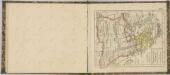
Maps of Greece

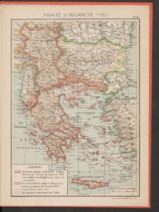
Traité de Bucarest (1913)
Makedonien Bukarest / Friede <1913> Kümmerly & Frey
Gegenwärtig Stand der neuen politischen Grenzen auf der Balkan-Halbinsel
1 : 1600000 Balkánský poloostrov Rothaug, Johann Georg G. Freytag & Berndt
Graecia Epirus Macedonia Moesia Thracia
Schul-Atlas der alten Welt bei Justus Perthes
Turkey in Europe. Greece.
1 : 3500000 Schonberg & Co.
Die Balkan-Halbinsel in 4 Blättern : Türkei, Rumänien, Griechenland, Serbien, Montenegro, Bulgarien
1 : 1500000 Vogel, C. (Carl), 1828-1897 Justus Perthes
Die Balkan-Halbinsel
1 : 1500000 Athény (Řecko : oblast) Vogel, Carl Domann, B. Justus Perthes
Die Balkan-Halbinsel
1 : 1500000 Athény (Řecko : oblast) Vogel, Carl Domann, B. Justus Perthes
Südosteuropäische Halbinsel, Geologische Übersicht
Südosteuropa
Anbau und Juli-Isothermen
Balkanhalbinsel Pflanzenbau, Klima
Soubor němých map pro gymnasia a odborné školy

Der Europäische Theil des Osmanischen Reichs oder die Europäische Türkey
Stieler's Hand-Atlas Stieler, Adolf bei Justus Perthes
Politisch - militärische Karte der Balkanhalbinsel

Turkey In Europe.
1 : 10700000 Mitchell, Samuel Augustus
Graeciae et Archipelago divisus in singulares regiones Macedoniae, Albaniae, Epiri, Thessaliae, Achaiae et Moreae, quibus accedunt insulae Candia, Corcyra, Cephalonia, Zacyntho, Stalimine, Metelino, Chius, etc
1 : 1600000 per Gerardum et Leonardum Valk [Amsterdam] : Valk
Türkei und Griechenland.
1 : 5000000 Osmanisches Reich / Europäischer Teil, Griechenland
Balkan-Halbinsel, Flusz- & Gebirgskarte
1 : 6000000 Balkanhalbinsel
Die Europaeische Türkei, Griechenland und die Jonischen Inseln
E. von Sydow's Schul-Atlas in sechs und dreissig Karten Sydow, Emil von bei Justus Perthes
Balkan-Halbinsel, politische Übersicht
1 : 6000000 Balkanhalbinsel
Das Osmanische Reich in Europa, Griechenland und die Jonischen Inseln
Schul-Atlas über alle Theile der Erde nach dem neuesten Zustande, und über das Weltgebäude Stieler, Adolf Justus Perthes
Die EuropaeischeTuerkey, Griechenland und die Jonischen Inseln
Osmanisches Reich / Europäischer Teil, Griechenland
Anbau und Januar-Isothermen
Balkanhalbinsel Pflanzenbau, Klima
Die Europäische Türkey, Griechenland und die Jonischen Inseln
Schul-Atlas über alle Theile der Erde nach dem neuesten Zustande, und über das Weltgebäude Stieler, Adolf bei Justus Perthes

Makedonische Frage: Gebietsansprüche ca. Anfang 1912
Makedonien Balkankrieg <1912-1913>, Territorialer Anspruch Zwick, J. ; Clewing, K.
Turkey in Europe.
1 : 5860000 Tanner, Henry S.
Balkan-Halbinsel
Balkanhalbinsel
Turkey in Europe.
1 : 1964160 Rand McNally and Company
Evropské Turecko, Černá Hora, Řecko a Jonské ostrovy
1 : 3000000 Jónské ostrovy (Řecko) Stojanov, Vasil