Maps of Europe

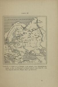
Carte de la Pologne à son apogee, sous Sigismond-Auguste, en face du Principat de Russie sous le czar Ivan IV, vers l’an 1570 de notre ère
Polen Russland Polen-Litauen Zygmunt August
Eastern Europe.
1 : 14495100 Fisher, Richard Swainson
Mapa slovanského světa

Volkerkarte von Russland.
1 : 13300000 Andree, Richard
Tabula Russiae ex autographo, quod delineandum curavit Foedor filius Tzaris Boris desumta [...] [Karte], in: Theatrum orbis terrarum, sive, Atlas novus, Bd. 1, S. 67.
1 Karte aus Atlas Blaeu, Joan Blaeu, Willem Janszoon
Novissima Russiae Tabula [Karte], in: Gerardi Mercatoris et I. Hondii Newer Atlas, oder, Grosses Weltbuch, Bd. 1, S. 124.
1 Karte aus Atlas Mercator, Gerhard und Hondius, Jodocus Jansson, Jan
Russland
1 : 15000000 Evropa východní Kocen, Blaž Eduard Hölzel
Tabvla Rvssiæ / ex autographo, quod delineandum curavit Foedor filius tzaris Boris desumta; et ad f
1 : 9000000 1 Karte : Kupferdruck ; 41 x 53 cm Fëdor excusum apud Guiljelmum Blaeu
Tabula Russiae ex autographo, quod delineandum curavit Foedor filius Tzaris Bori et ad fluvios Dwina
1 : 1100000 1 Karte : Kupferdruck ; 27 x 34 cm [Matthäus Merian d. Ältere]
Soubor němých map pro gymnasia a odborné školy

Mapa slovanského světa

Novissima Russiae Tabula [Karte], in: Novus atlas absolutissimus, Bd. 1, S. 70.
1 Karte aus Atlas Janssonius Offizin
[Europaeisches Russland auch Schweden u. Norwegen, Dabei Uebersicht des Oesterreichischen u. Preussischen Staats]
Hand-Atlas über alle Theile der Erde nach dem neuesten Zustande und über das Weltgebäude Stieler, Adolf bei Justus Perthes
Tabula Russiae [...] [Karte] Moscua ad Architypum Foedori Borißowitsi [Planvedute, Karte], in: Le théâtre du monde, ou, Nouvel atlas contenant les chartes et descriptions de tous les païs de la terre, Bd. 1, S. 67.
1 Karte aus Atlas Blaeu, Willem Janszoon und Blaeu, Joan Blaeu, Willem Janszoon
Etnografska karta na slavjanstvoto v Evropa
1 : 5000000 Evropa východní Florinskij, Timofej Dmitrijevič Slavjanska besěda
Russland
1 : 36000000 Russland / Europäischer Teil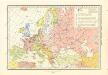
Historický atlas revolučního hnutí

Des Russischen Reichs Europäischer Theil
Stieler's Hand-Atlas Stieler, Adolf bei Justus Perthes
Russia cum confiniis. [Karte] Russiae Pars Amphlificata [Nebenkarte], in: Gerardi Mercatoris Atlas, sive, Cosmographicae meditationes de fabrica mundi et fabricati figura, S. 158.
1 Karte aus Atlas Mercator, Gerhard Montanus, Petrus
Mapa slovanského světa

Tabula Russiae [...] [Karte] Moscua [Planvedute, [Nebenkarte], in: Novus Atlas, das ist, Weltbeschreibung, Bd. 1, S. 55.
1 Karte aus Atlas Blaeu, Joan Blaeu, Willem Janszoon
Ruszland
1 : 12000000 Russland / Europäischer Teil
Russia in Europe.
1 : 7450000 Hughes, William
Russland beim Tode Katharinas II. 1796
Russland
Russland beim Tode Peters d. Gr. 1725
Russland
Russland und Skandinavien
Handatlas über alle Theile der Erde und über das Weltgebäude Stieler, Adolf Justus Perthes
Russland
Neuer Handatlas über alle Theile der Erde Kiepert, Heinrich Verlag von Dietrich Reimer
Russia, Sweden, Norway.
1 : 15000000 Mitchell, Samuel Augustus
Russia, Sweden, Norway.
1 : 15000000 Mitchell, Samuel Augustus
Russia, Sweden, Norway.
1 : 15000000 Mitchell, Samuel Augustus Jr.
Russia, Sweden, Norway.
1 : 15000000 Mitchell, Samuel Augustus
Russia, Sweden, Norway.
1 : 15000000 Mitchell, Samuel Augustus