Maps of Karelia

[Nordrussland ; Vieh]
Russland Russland (Nord) Landwirtschaft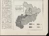
[Nordrussland ; Vieh]
Russland Russland (Nord) Landwirtschaft
Počvy ozernoj oblasti
Russland Russland (Nord) Geografie Sibircev, K.
Geologičeskoe stroenīe ozernoj oblasti
Russland Russland (Nord) Geologie Geol. Komitet
Raspredělenie lěsov i preděly rasprostranenīja někotorych porod derev'ev v ozernoj oblasti
Russland Russland (Nord) Geografie Bewaldung Il'in', N.
Raspredělenie škol v ozernoj oblasti
Russland Russland (Nord) Schule Stavrovskij, Ja.
Rel'ef ozernoj oblasti
Russland Russland (Nord) Geografie Tillo, A. ; Šokal'skij, Ju.
Nedostajuščee količestvo prodovol'stvennago chlěba na dušu sel'skago naselenīja
Russland Russland (Nord) Ernährung Moračevskij, V.
Plemena ozernoj oblasti
Russland Russland (Nord) Ethnische Gruppe Stavrovskij, Ja.
Plotnost' naselenīja ozernoj oblasti
Russland Russland (Nord) Bevölkerungsdichte Moračevskij, V.
[Nordrussland ; Pferd]
Russland Russland (Nord) Landwirtschaft
No.20. Karta Evropeyskaia Rossiia. Sheet 6
1 : 2000000 Shokalskago,Iu. M.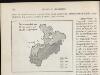
[Nordrussland ; Pferd]
Russland Russland (Nord) Landwirtschaft
Karta ozernoj oblasti
Russland Russland (Nord) Il'in', N.
Europäisches Russland
Hand-Atlas über alle Theile der Erde nach dem neuesten Zustande und über das Weltgebäude Stieler, Adolf bei Justus Perthes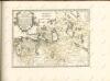

Feuille 19 (E III), uit: Carte géologique internationale de l'Europe : la carte, votée au congrès géologique international de Bologne en 1881, est exécutée conformément aux décisions d'une commission internationale, avec le concours des gouvernements, sous le dir. de M.M. Beyrich et Hauchecorne
Annotatie: Blad 48 gamme des couleurs; blad 49: bladwijzer en titelblad Heinrich Ernst Beyrich 1815-1896; Wi. Hauchecorne Berlin : Reimer / (Berlin: Institut lithographique)
RVSSIÆ, | Vulgo MOSCOVIA dictæ, | Pars Occidentalis
Auctore Isaaco Maßa. [Amsterdam : Joan Blaeu]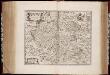
Rvssiæ, vulgo Moscovia dictæ, pars occidentalis / auctore Isaaco Maßa
1 : 2000000 Annotatie: Kaart is vervaardigd omstreeks 1638, en gepubliceerd in de Atlas Maior in 1662; Met wapen; Origineel is Blad 138 in atlas factice; Annotatie geografische gegevens: Met 2 schaalstokken Isaac Abrahamszoon Massa 1586-1643 [Amsterdam : apud Johan. et Cornelium Blaeu]
Russia 4.
1 : 1900800 Letts, Son & Co.
Russia Part lV.
1 : 1770000 Society for the Diffusion of Useful Knowledge (Great Britain)
Moscovia
1 : 4500000 1 Karte : Kupferdruck ; 12 x 17 cm Hondius, Jodocus [Verlag nicht ermittelbar]
Moscovia
1 : 4500000 1 Karte : Kupferdruck ; 12 x 17 cm Mercator, Gerhard printed by William Stansby for Henrie Fetherstone
Partie, Russie d'Europe. Europe 5.
1 : 1641836 Vandermaelen, Philippe, 1795-1869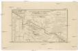
Karta napravlenija železnoj dorogi šossei i vodjanych soobščenij meždu S. Peterburgom i Moskvoju
1 : 1300000 Moskva-oblast (Rusko) Al'tman, I. Flerov, V. v Zavedenii kongrevskoj chromotipii F. Tuma
Partie, Russie d'Europe. Europe 10.
1 : 1641836 Vandermaelen, Philippe, 1795-1869
Karelische Autonome Sozialistische Sowjetrepublik 1923
Karelien, Karelische Autonome Sozialistische Sowjetrepublik Hösch, Riika
Schema kʺ pochodamʺ Sv. V. Knjazja Aleksandra Nevskago.
Russland Feldzug Aleksandr Nevskij
Karelische Arbeiterkommune 1920
Karelien Kommune, Arbeiter Hösch, Riika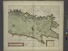
![[Nordrussland ; Vieh]](https://images-2.georeferencer.com/images/iiif/916560926668/full/,300/0/native.jpg)

