Maps of Pułtusk

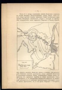
Schema Pultusskago sraž.
Polen Pułtusk Napoleonische Kriege
Warschau 52, uit: Special-Karte von Mittel-Europa / nach amtlichen Quellen bearbeitet von W. Liebenow
1 : 300000 titelvariant: W. Liebenow's Mittel-Europa; Annotatie: Titel boven de bladen: W. Liebenow's Mittel-Europa Johannes Wilhelm Liebenow 1822-1897 Frankfurt a. M. : Ludwig Ravenstein
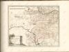
Warszawa
Feldzug der Russen und Polen zwischen Bug und Narew vom 13ten bis 26sten Mai 1831

Warszawa, Brest-Litowsk, Radom, Lublin, Kielze, Tomaszów

Sect. 11: Allenstein, uit: Geologische Karte des Deutschen Reichs in 27 Blaettern / [von] Richard Lepsius ; Red. von C. Vogel
1 : 500000 Annotatie: Blad 18 ontbreekt; Een aantal bladen op linnen; Een aantal bladen gereviseerd 1913-1914; Annotatie geografische gegevens: Met schaalstokken o.a. in kilometers; Legenda Carl Vogel 1828-1897 Gotha : Justus Perthes
West Galizien
Chełm-oblast (Polsko) Müller, Karl Benedict, Ant. Kunst und Industrie Comptoirs
West Galizien
Halič (Polsko a Ukrajina) Müller, Karl Benedict, Ant. im Verlage des Kunst und Industrie Comptoirs
West-Galizien
Chełm-oblast (Polsko) Müller, Karl Benedict, Ant. im Verlage des Kunst und Industrie Comptoirs
Religion and language maps of Lublin province, Poland no.08
1 : 750000 Religion and language maps of Lublin province, Poland. Religion map by gminas showing relative majorities according to figures of Warsaw Statistical Committee, 1909. Based on information strongly biassed against the Catholics. War Office
Topographische Karte der Gegend um Warschau
Varšava-oblast (Polsko) Artaria
Übersichtskarte von Mittel - Europa

Übersichtskarte von Mittel - Europa

Schema Teatra kampanīi 1806-7 gg.
Polen Napoleonische Kriege

Nr. 12. Die ersten Schlachten in Ostpreußen
Ostpreußen Weltkrieg <1914-1918>

Zweite Offensive in Polen
1 : 4000000 Polen Feldzug, Weltkrieg <1914-1918>
[Polen]
1 : 800000 Polsko S. Hirzel
West-Galizien
1 : 850000 Halič (Polsko a Ukrajina) Metzburg, Georg Ignaz von Junker, Ch. T. Mollo und Comp.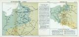
Nr. 18a. Die Winterschlacht in Masuren
Masuren Weltkrieg <1914-1918>, Ostfront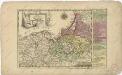
Das Königreich Preussen

Ost- und West-Preussen
Grosser Hand-Atlas über alle Theile der Erde in 170 Karten Meyer, J. Verlag des Bibliographischen Instituts
Karte der Eisenbahnen Deutschlands
1 : 700000 Nordost-Blatt Stich, Druck u. Verlag des lithographischen Instituts von Aug. Wehrt
Preussen, Ost- u. West.
1 : 1320000 Radefeld, Carl Christian Franz, 1788-1874
Prussia.
1 : 1900000 Bowen, Frances
Kreise der Provinz Preußen 1864
Preußen, Provinz Preußen, Verwaltungsgliederung Kunz, Andreas ; Moeschl, Joachim Robert