Maps of Gemeinde Dürnstein

Sraženie pod Kremsom 30-go oktjabrja 1805 g.
Österreich Krems Napoleonische Kriege Kutuzov, Michail I.
Die Wachau
1 : 50000 Wachau (Rakousko) des Kartographischen, früher Militärgeographischen Institutes
Krems.
from Spezialkarte der osterreichisch-ungarischen Monarchie.
Wachau
1 : 100000 Weigl, August Kartografische Anstalt G. Freytag & Berndt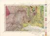
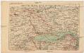
Umgebungen von Krems

Umgebungskarte von Krems und Zwettl
1 : 75000 R. Lechner
Monumenta Cartographica Bohemiae II.: Müllerova mapa
Localstrecke von Wien K. F. J. B. bis Krems mit Umgebung
Kremže (Rakousko) K. k. Österreichische Staatsbahnen
Das in dem Ertzhertzogtumb Vnter Osterreich
1 : 246000 Dolní Rakousko (Rakousko) Vischer, Georg Matthaeus Hoffmann, Jakob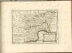

Znaim 132, uit: Special-Karte von Mittel-Europa / nach amtlichen Quellen bearbeitet von W. Liebenow
1 : 300000 titelvariant: W. Liebenow's Mittel-Europa; Annotatie: Titel boven de bladen: W. Liebenow's Mittel-Europa Johannes Wilhelm Liebenow 1822-1897 Frankfurt a. M. : Ludwig Ravenstein
Ob Mannharts Berg
1 : 640000 Mollova mapová sbírka Insprugger, Sebastianus Märtin, Johann Heinrich Voigt, Maria Theresia

Carte Topographique d'Allemagne.
1 : 220000 Mollova mapová sbírka Jaeger, Johann Wilhelm Abraham Berndt, Johann Christoph Jäger, Johann Wilhelm Abraham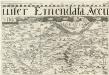
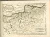
Archiducatus Austriae inferioris Geographica, et Nouiter Emendata Accuratissima Descriptio :
1 : 153333 Mollova mapová sbírka Vischer, Georg Matthaeus Hoffmann, Jakob
Archiducatus Austriae inferioris Geographica, et Nouiter Emendata Accuratissima Descriptio :
1 : 153333 Mollova mapová sbírka Vischer, Georg Matthaeus Hoffmann, Jakob
General-Karte zu den Corps-Manövern bei Waidhofen a[n] [der Thaya] 1891
1 : 300000 Waidhofen an der Thaya (Rakousko)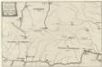
Locus Conjuctionis Danubij cum Moldava
Mollova mapová sbírka Vogemont, Lothar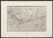
Militair Karte von Süd-Deutschland in 20 Sectionen
1 : 400000 12. Section Coulon, Alois von A. von Coulon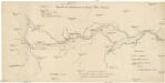
Übersicht der Canaltracen der Strecke Wien-Budweis
1 : 300000 Vídeň (Rakousko) Staff, A. Rosenberg, K.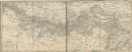
Die Donau von Passau bis Wien mit Umgebungen

Vermehrte und Verbesserte Landkarten des Königreichs Ungarn :
1 : 500000 Mollova mapová sbírka Stier, Martin Böner, Johann-Alexander Endter, Martin
Das in dem Ertzhertzogtumb Vnter Osterreich.
1 : 250000 Mollova mapová sbírka Vischer, Georg Matthaeus Hoffmann, Jakob
Das in dem Ertzhertzogtumb Vnter Osterreich.
1 : 250000 Mollova mapová sbírka Vischer, Georg Matthaeus Hoffmann, Jakob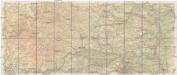
Hölzels Strassen-Karte von Österreich für Automobilisten und Radfahrer
1 : 200000 Kremže (Rakousko) Geogr. Institut Ed. Hölzel
Hertzogthums Oesterreich
1 : 288000 Dolní Rakousko (Rakousko) Stein, Carl geografischen Institute
[Südlichen Böhmen und nördlichen Österreich]
Rakousko severní Reisenauer
Morauia. Austria
Mollova mapová sbírka Hoffmann, Johannes Hoffmann, Johann