Maps of Timișoara

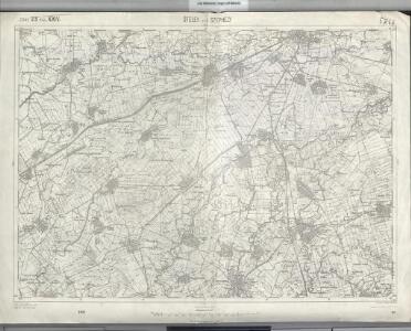
Ótelek und Széphely
1 : 75000 Timiş Geripp: Fwkr. Acham. Terrain: Oberlt. Peraković
Lambert-Cholesky sheet 1657 (Parța)
1 : 20000 Romanian military topographic map sheet under Lambert-Cholensky projection Direcția Topografică Militară geo-spatial.org Direcția Topografică Militară
Lambert-Cholesky sheet 1656 (Ciacova)
1 : 20000 Romanian military topographic map sheet under Lambert-Cholensky projection Direcția Topografică Militară geo-spatial.org Direcția Topografică Militară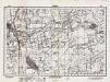
Lambert-Cholesky sheet 1757 (Pădureni)
1 : 20000 Romanian military topographic map sheet under Lambert-Cholensky projection Direcția Topografică Militară geo-spatial.org Direcția Topografică Militară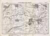
Lambert-Cholesky sheet 1658 (Sânmihaiul Român)
1 : 20000 Romanian military topographic map sheet under Lambert-Cholensky projection Serviciul Geografic al Armatei geo-spatial.org Serviciul Geografic al Armatei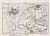
Lambert-Cholesky sheet 1756 (Jebel)
1 : 20000 Romanian military topographic map sheet under Lambert-Cholensky projection Direcția Topografică Militară geo-spatial.org Direcția Topografică Militară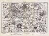
Lambert-Cholesky sheet 1758 (Timişoara)
1 : 20000 Romanian military topographic map sheet under Lambert-Cholensky projection Direcția Topografică Militară geo-spatial.org Direcția Topografică Militară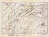
Lambert-Cholesky sheet 1557 (Uivar)
1 : 20000 Romanian military topographic map sheet under Lambert-Cholensky projection Direcția Topografică Militară geo-spatial.org Direcția Topografică Militară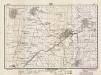
Lambert-Cholesky sheet 1558 (Cenei)
1 : 20000 Romanian military topographic map sheet under Lambert-Cholensky projection Direcția Topografică Militară geo-spatial.org Direcția Topografică Militară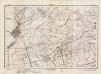
Lambert-Cholesky sheet 1556 (Ivanda)
1 : 20000 Romanian military topographic map sheet under Lambert-Cholensky projection Direcția Topografică Militară geo-spatial.org Direcția Topografică Militară
Plan ataki ukrěplenija v Temešskom uščel'i 8 ijunja 1849 goda
1 : 7200 Temeš (Rumunsko a Srbsko) Beketov, V.
Otelek und Szephely.
from Spezialkarte der osterreichisch-ungarischen Monarchie.
Plan der Angriffsarbeiten gegen die Festung Temesvár im Jahre 1849
1 : 14000 Temešvár (Rumunsko)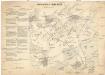
Schlacht von Temesvár am 9. August 1849
1 : 60300
Plan der Angriffsarbeiten gegen die Festung Temesvár im Jahre 1849
Walzel, A. F.
Neuster Plan der kays. Attaque vor Temeswar
Temešvár (Rumunsko)
Übersicht-Karte von der südlichen größeren Hälfte des Temesvarer Banat's
1 : 230000 Banát Petrovics, Paul k. k. Generalquartiermeistabes
C. Temesiensis
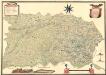
Rumänien Komitat Temesvár
Tekintetes Temes vármegye térképe
Temešvár (Rumunsko) Györy, Lajos Beichel, J.
Temesvar und Sandorhaza.
from Spezialkarte der osterreichisch-ungarischen Monarchie.
Felsoittebe.
from Spezialkarte der osterreichisch-ungarischen Monarchie.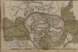
[Temeswar]
Timişoara Stadtbefestigung
Übersichts-Karte von der südlichen und grösseren Hälfte des Temesvarer Banat's
1 : 230000 Banát Petrovics, Paul Sollinger, Johann Paul
Mappa Der Grenz Scheidung Des Banat Temeswar Von Anno 1749 Mit Den Türken Geschlosen Von Herren General Feldmarschaů Lieutinont Freiheren Frantz Von Engelshofen A. 1749
Mollova mapová sbírka Geyer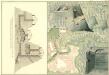
Plan des Bergwergs zu Lupkovo
Mollova mapová sbírka Geyer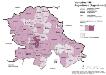
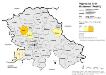
Vojvodina 1981. Jugoslawen (Jugosloveni)
Wojwodina ethnische Gruppe, Jugoslawen Hofinger, Veronika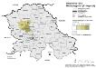
Vojvodina 1981. Montenegriner (Crnogorci)
Wojwodina ethnische Gruppe, Montenegriner Hofinger, Veronika
Vojvodina 1981. Nationalitäten
Wojwodina ethnische Gruppe Hofinger, Veronika