Maps of Tiszaújvárosi járás

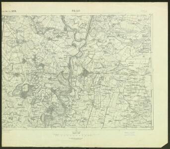
Polgár
1 : 75000 Polgár, Umland Schrift und Gerippe v. Feldw. Rücker. Terrainschraffirung v. Fwkr. Nowak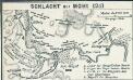
Schlacht bei Mohi 1241
1 : 185000 Muhi Muhi / Schlacht
Polgar (Ungarn).
from Spezialkarte der osterreichisch-ungarischen Monarchie.
Miskolcz 136, uit: Special-Karte von Mittel-Europa / nach amtlichen Quellen bearbeitet von W. Liebenow
1 : 300000 titelvariant: W. Liebenow's Mittel-Europa; Annotatie: Titel boven de bladen: W. Liebenow's Mittel-Europa Johannes Wilhelm Liebenow 1822-1897 Frankfurt a. M. : Ludwig Ravenstein
C. Borsodiensis
Ungarn Komitat Borsod

Comitat Nord-Bihar
1 : 288000 Debrecín (Maďarsko)
Borsoder Comitat
1 : 288000
Borsoder Comitat
1 : 288000
Borsod vármegye
1 : 410000 Görög, Demeter Biller, Bernhard Görög
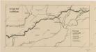
Szikszo und Tisza-Dob.
from Spezialkarte der osterreichisch-ungarischen Monarchie.
Nyiregyhaza und Hajdu-Nans.
from Spezialkarte der osterreichisch-ungarischen Monarchie.
Erlau und Mezo-Keresztes..
from Spezialkarte der osterreichisch-ungarischen Monarchie.
Neubertova generální automapa Republiky československé
1 : 200000 Debrecín (Maďarsko : oblast) Soukup, Jan V. Neubert a synové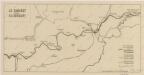
Sbírka map a diagramů použitých na mírových konferencích v Paříži v letech 1919 - 1920
Sbírka map a diagramů použitých na mírových konferencích v Paříži v letech 1919 - 1920

Siedlungsgebiet der Slowaken nach dem Nachbarschaftsindex für Nordost-Ungarn 1941
Ungarn (Nordost) Slowaken, Siedlung Bottlik, Zsolt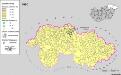
Siedlungsgebiet der Slowaken nach dem Nachbarschaftsindex für Nordost-Ungarn 1980
Ungarn (Nordost) Slowaken, Siedlung Bottlik, Zsolt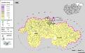
Siedlungsgebiet der Slowaken nach dem Nachbarschaftsindex für Nordost-Ungarn 1880
Ungarn (Nordost) Slowaken, Siedlung Bottlik, Zsolt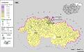
A szlovákok településterülete a szomszédsági mutató alapján Északkelet-Magyarországon 1880-ban
Ungarn (Nordost) Slowaken, Siedlung Bottlik, Zsolt
A szlovákok településterülete a szomszédsági mutató alapján Északkelet-Magyarországon 1980-ban
Ungarn (Nordost) Slowaken, Siedlung Bottlik, Zsolt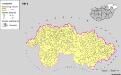
A szlovákok településterülete a szomszédsági mutató alapján Északkelet-Magyarországon 1941-ban
Ungarn (Nordost) Slowaken, Siedlung Bottlik, Zsolt
Vermehrte und Verbesserte Landkarten des Königreichs Ungarn :
1 : 500000 Mollova mapová sbírka Stier, Martin Böner, Johann-Alexander Endter, Martin
Partis Hungariae Inter Tibiscum et Nigrum Chrysum Nova et Accurata Descriptio
1 : 530000 Mollova mapová sbírka Valk, Gerhard Schenk, Peter I
Ober Ungern
Slovensko východní Kipferling, Karl Joseph Müller, Karl im Verlage des Kunst und Industrie Comptoir's
Ober Ungern
Slovensko východní Kipferling, Karl Joseph Müller, Karl im Verlage des Kunst und Industrie Comptoir's
Rumänen in Ost-Ungarn 1941
Ungarn (Ost) Rumänen, Siedlung Bottlik, Zsolt
Die Donau, der Fürst aller Europaeischen Flüsse :
Mollova mapová sbírka Hoffmann, Johannes Hoffmann, Johann
Rumänen in Ost-Ungarn 1880
Ungarn (Ost) Rumänen, Siedlung Bottlik, Zsolt